Lightweight GIS service method and device, electronic equipment and storage medium

A lightweight and service interface technology, applied in the field of GIS services, can solve problems such as the inability to efficiently provide lightweight services for GIS products, and achieve the effects of lightweight services, reduced difficulty in secondary development, and easy-to-use product deployment

Pending Publication Date: 2022-05-13
武汉达梦数据技术有限公司
View PDF0 Cites 0 Cited by
  • Summary
  • Abstract
  • Description
  • Claims
  • Application Information

AI Technical Summary

Problems solved by technology

[0005] In view of this, it is necessary to provide a lightweight GIS service method, device, electronic equipment and storage medium to overcome the problem of being unable to efficiently provide lightweight services for GIS products in the prior art

Method used


Image

  • Lightweight GIS service method and device, electronic equipment and storage medium
  • Lightweight GIS service method and device, electronic equipment and storage medium
  • Lightweight GIS service method and device, electronic equipment and storage medium

Examples


Embodiment Construction

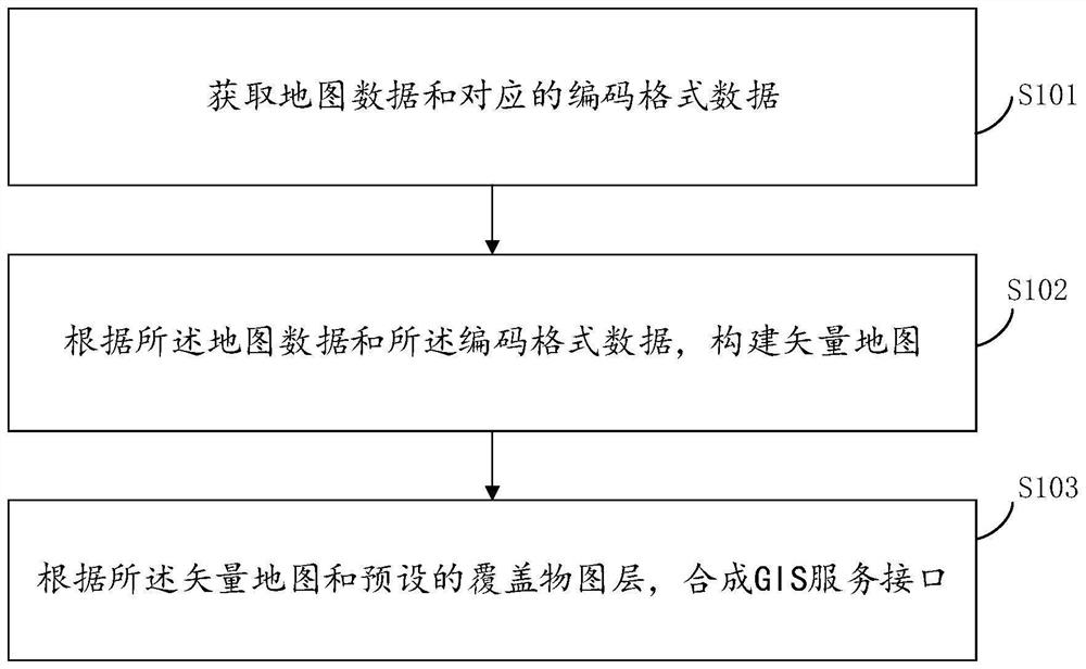
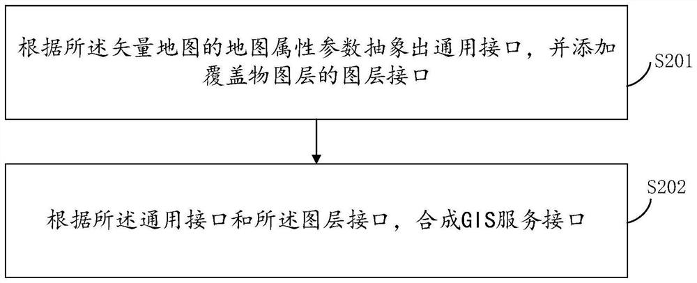
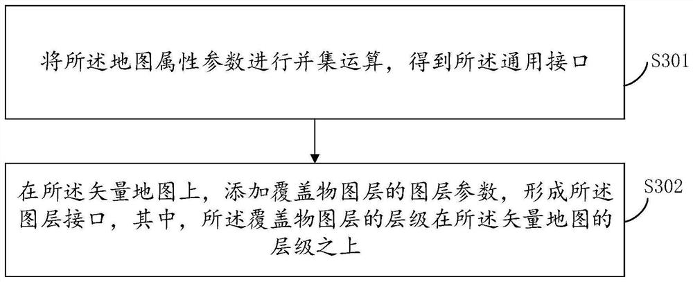
[0034] Preferred embodiments of the present invention will be described in detail below in conjunction with the accompanying drawings, wherein the accompanying drawings constitute a part of the application and together with the embodiments of the present invention are used to explain the principle of the present invention and are not intended to limit the scope of the present invention.

[0035] In the description of the present invention, the terms "first" and "second" are only used for descriptive purposes, and cannot be understood as indicating or implying relative importance or implicitly specifying the quantity of indicated technical features. Thus, the features defined as "first" and "second" may explicitly or implicitly include at least one of these features. In addition, "plurality" means at least two, such as two, three, etc., unless otherwise clearly and specifically defined.

[0036] In the description of the present invention, reference to "an embodiment" means tha...


PUM


Abstract

The invention relates to a lightweight GIS service method and apparatus, an electronic device and a storage medium. The method comprises the steps of obtaining map data and corresponding coding format data; constructing a vector map according to the map data and the coded format data; and synthesizing a GIS service interface according to the vector map and a preset coverage layer. According to the invention, lightweight GIS service capability is provided, system operation and maintenance pressure is reduced, independent deployment of GIS products is not needed, basic GIS functions required by an information system are provided, secondary development difficulty is reduced, a synthesized GIS service interface can be utilized, charts and other self-defined html contents can be flexibly displayed, linkage between the GIS and chart data is realized, and the method and the system have the advantages of simple operation and high efficiency. Moreover, the product deployment is simple and easy to use, and the purpose of service lightweight is achieved.

Description

technical field [0001] The invention relates to the technical field of GIS services, in particular to methods, devices, electronic equipment and storage media for lightweight GIS services. Background technique [0002] The GIS maps currently used in information systems are generally divided into two categories, one is independently deployed on the intranet, based on the B / S architecture, and can provide complete vector map services, such as hypermap; the other is the open Internet For secondary development platforms, such as Baidu Maps, Height Maps, Tiandi Maps, etc., developers only need to apply for a license or key, and then download the client SDK package to use it. [0003] These two deployment methods have their own usage scenarios, but their disadvantages are also obvious. The third-party GIS platform based on the B / S architecture needs to install the GIS server independently, and the data files are huge, which is very inconvenient for both installation and operation...

Claims


Application Information

Patent Timeline
Patent Type & Authority Applications(China)
IPC IPC(8): G06T11/20G06F16/29G06F16/22G06F16/2455G06F13/10
CPCG06F16/29G06F16/25G06F16/26G06F16/56G06F16/54G06F16/587
Inventor 徐鸿雁石元春赵寅
Owner 武汉达梦数据技术有限公司
Why Eureka
Try Eureka