Three-dimensional mapping method, system and device for granary and storage medium
A granary, three-dimensional technology, applied in the field of grain storage, can solve the problems of heavy workload, wet and moldy grain, inconvenient access to grain, etc., to achieve the effect of enhancing universality, facilitating storage, and reducing concerns about wet environments
- Summary
- Abstract
- Description
- Claims
- Application Information
AI Technical Summary
Problems solved by technology
Method used
Image

Examples
Embodiment 2
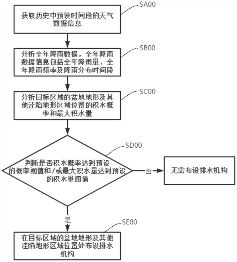
[0098] refer to image 3 , the difference from Example 1 is:
[0099] The step of synchronizing with S100 further includes steps SA00~SE00:
[0100] Step SA00: Obtain weather data information of a preset time period in the history.
[0101] By establishing a communication connection with the weather system, the current executive body (such as a controller) obtains historical weather data, for example, the weather data for the past two consecutive years.
[0102] Step SB00: Based on the weather data information of the preset time period in the history, analyze and obtain the annual rainfall data, and the annual rainfall data information includes the annual rainfall amount, the annual rainfall frequency and the rainfall distribution time period.
[0103] Specifically, weather factors also need to be considered when laying out the drainage mechanism, so it is necessary to obtain annual rainfall data based on local historical weather data. The air humidity is high, which is not...
Embodiment 3
[0111] refer to Figure 4 , the difference from Example 2 is:
[0112] After the step of step SA00 (obtaining weather data information of a preset time period in the history), it also includes Sa00~Sh00:
[0113] Step Sa00: Based on the weather data information of the preset time period in the history, the preset time period is at least two complete years, and analyze the annual climate characteristics of the target area.
[0114] Specifically, after obtaining the weather data of at least two years in previous years, the annual climate characteristics of the target area can be inferred, such as tropical rain forest climate, savannah climate, subtropical monsoon climate and temperate continental climate.
[0115] Step Sb00: Based on the annual climate characteristics of the target area, predict the seasonal climate characteristics of the future time period.
[0116] Specifically, when the target area belongs to a temperate continental climate, the climate characteristics are:...
Embodiment 4
[0128] refer to Figure 5 , the difference from Example 3 is:
[0129] After the step of analyzing and obtaining the forest vegetation area and plant variety information of the target area in step Se00, steps Se10-Se40 are further included:
[0130] Se10: Determine whether the plant species is a water storage plant species, and at the same time determine whether the forest vegetation area reaches a preset area threshold.
[0131] Se20: If the plant species is a water storage plant species and the forest vegetation area does not reach the preset area threshold;
[0132] Or, if the plant species is not a water storage plant species and the forest vegetation area reaches a preset area threshold;
[0133] Then, based on the real photo information, the soil infiltration rate information of the target area is obtained by analysis.
[0134] If the plant species does not belong to the water storage plant species and the forest vegetation area does not reach the preset area threshol...
PUM
 Abstract
Description
Claims
Application Information
 - Generate Ideas
- Intellectual Property
- Life Sciences
- Materials
- Tech Scout
- Unparalleled Data Quality
- Higher Quality Content
- 60% Fewer Hallucinations
Browse by: Latest US Patents, China's latest patents, Technical Efficacy Thesaurus, Application Domain, Technology Topic, Popular Technical Reports.
© 2025 PatSnap. All rights reserved.Legal|Privacy policy|Modern Slavery Act Transparency Statement|Sitemap|About US| Contact US: help@patsnap.com