
Method for determining conflicting paths between mobile airborne vehicles and associated system and computer software program product

A technology of flight paths and software programs, applied in the field of computer software program products, can solve the problems that cannot be used to calculate the horizontal distance or horizontal distance, the magnitude of the error increases, and the flat ground model is not accurate.

Inactive Publication Date: 2005-03-09
UNITED PARCEL SERVICE OF AMERICAN INC
View PDF0 Cites 18 Cited by
  • Summary
  • Abstract
  • Description
  • Claims
  • Application Information

AI Technical Summary

Problems solved by technology

However, since the Earth is more spherical in shape, the magnitude of the error increases as latitude moves away from the equator
Thus, at or near the poles, flat ground models are inaccurate and generally cannot be used to calculate their horizontal spacing or horizontal distance

Method used


Image

  • Method for determining conflicting paths between mobile airborne vehicles and associated system and computer software program product
  • Method for determining conflicting paths between mobile airborne vehicles and associated system and computer software program product
  • Method for determining conflicting paths between mobile airborne vehicles and associated system and computer software program product

Examples


Embodiment Construction

[0017] The present invention will be described more fully hereinafter with reference to the accompanying drawings in which preferred embodiments of the invention are shown. This invention may, however, be embodied in different forms and should not be construed as limited to the embodiments set forth herein; rather, these embodiments are provided so that this disclosure will be thorough and complete and complete to those skilled in the art. communicate the scope of the invention. In the drawings, the same reference numerals represent the same components.

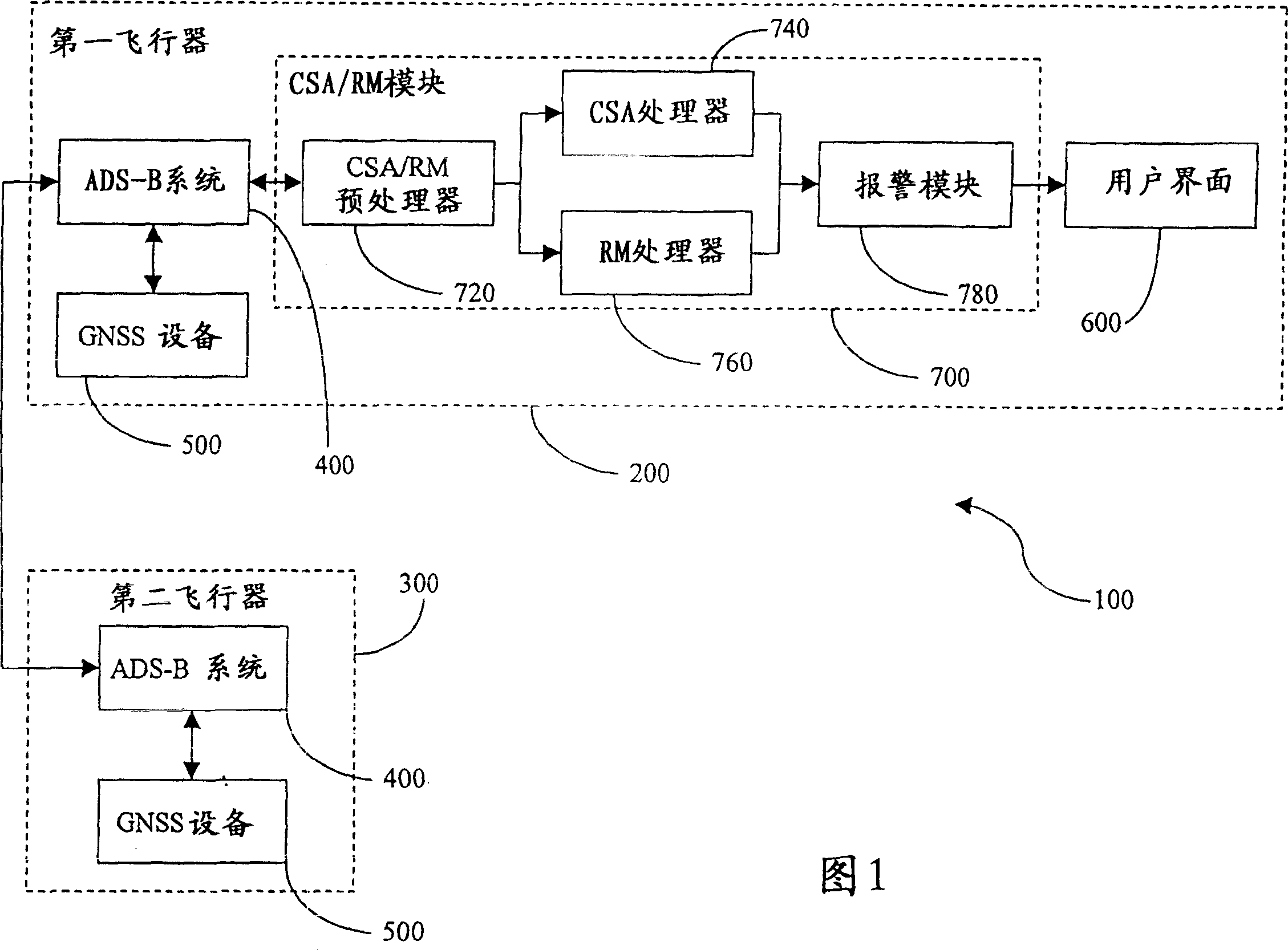
[0018] FIG. 1 schematically illustrates a system architecture, indicated by reference numeral 100 , representing a system for determining collision paths between active aircraft, according to one embodiment of the invention. The system architecture 100 plans the analysis of a collision flight path between a first aircraft ("surveillance aircraft") 200 and a second aircraft ("target aircraft") 300, wherein those skilled in th...


PUM


Abstract

A method of determining conflicting flight paths between a first and a second airborne vehicle is provided, wherein each vehicle comprises an aircraft-to-aircraft navigational communication system having a navigational device. First, a position and a velocity vector are determined for each of the airborne vehicles. A cylindrical volume is then defined about the first airborne vehicle. A separation distance is then determined between the vehicles at a selected time and using a great circle earth model. An accuracy factor is thereafter determined for the position of each vehicle. The separation distance is then modified by the accuracy factor. A determination is then made as to whether the modified separation distance is within the cylindrical volume about the first airborne vehicle during a time range to thereby determine whether conflicting flight paths exist between the vehicles. An associated system and computer software program product are also provided.

Description

technical field [0001] The present invention relates to collision avoidance systems, and more particularly to methods, systems and computer software program products for determining collision paths between active aircraft. Background technique [0002] Air traffic continues to increase as the number of aircraft in service continues to grow. Trends in travel demand and air cargo have also increased the number of aircraft in the air. Therefore, mid-air collision avoidance between aircraft has become very important as the tracking of large amounts of air traffic becomes more and more difficult. The speed and size of modern aircraft are factors that affect the difficulty of the tracking process, especially when multiple aircraft are involved. As airspace becomes limited and as temporal distances and separation distances decrease, approximations may no longer be acceptable. Additionally, the proposal to replace the current air exchange control system with a "free flight" syste...

Claims


Application Information

Patent Timeline
IPC IPC(8): B64D45/00G01S5/00G01S5/14G01S7/00G01S7/06G01S13/72G01S13/933G06Q50/00G08G5/00G08G5/04
CPCG01S13/9303G01S5/0009G08G5/0008G08G5/0078G01S7/06G08G5/0021G01S7/003G01S2013/466G01S13/726G01S13/933
Inventor 琴·莱
Owner UNITED PARCEL SERVICE OF AMERICAN INC
Learn More