Method and computer system for determining seismic node position

a node position and computer system technology, applied in seismology, seismology, instruments, etc., can solve the problems of unreliable pick-up and use of adverse impact on the reliability of using direct arrival energy for positioning analysis when the angle of departure of energy shots leaving the surface exceeds 70 degrees, and the node location measurement is very small

Active Publication Date: 2019-08-13
MAGSEIS FF LLC
View PDF11 Cites 13 Cited by
  • Summary
  • Abstract
  • Description
  • Claims
  • Application Information

AI Technical Summary

Benefits of technology

[0009]It is a primary object and advantage of the present invention to provide a method, system, and product that will improve data quality regardless of the angle at which the energy is shot from the surface.
[0010]Other objects and advantages of the present invention will in part be apparent to those of skill in the art, and in part appear hereinafter.SUMMARY OF THE INVENTION
[0011]In accordance with the foregoing object and advantage, the present invention provides a system and method for determining the x, y energy receiver (node) positions and to do so regardless of the angle at which the energy was released from the source. In general terms, once a seismic survey has been conducted and the nodes retrieved from the ocean's floor and their data downloaded to a computing system, the present process and system will use the initial picked arrival times (most typically in shallow water this will be of the first refractor as transit velocities of the refracted arrivals tend to be faster than typical water column velocities.) The process and system involves an iterative looping technique that is executed in data processing software wherein an initial model position in used based on, in essence, a best guess as to a node's location based upon where it was intended to be placed, followed with the iterative process of statistically comparing model data to actual data and then adjusting the model position by some predetermined amount and comparing this new result to the actual data to determine if the newly adjusted position is statistically better or worse than the originally selected position assumption. The process can be repeated using continuously smaller distance adjustments to the previously determined best position. Once satisfied that the true best position has been achieved, the processing can cease and the X, Y position data may be used in the normal course of generating seismic maps. The data processing is typically performed using the hydrophone channel, but can be performed using the vertical geophone with no modification to the sequence. In addition, accurate knowledge of the transit velocity or node depth is not necessary for this process to work.
[0012]In one aspect of the invention, a computer implemented method for updating and refining the X, Y positions of an ocean bottom node for use in creating a seismic survey through the use of data that has been sensed and collected by the node after emission from an energy shot source and in regard to energy intensity and energy arrival time at the node, is provided that generally comprises the steps of conditioning the data retrieved from the node; performing a position estimation routine on the conditioned data; performing a position estimation sub-routine on the conditioned data to determine a refined position of the node; performing a post-position processing of the data; and outputting the data.
[0013]In another aspect of the invention, a non-transitory computer readable medium is provided that generally comprises instructions that when executed cause a computer capable of processing data to perform the steps of conditioning the data retrieved from the node; performing a position estimation routine on the conditioned data; performing a position estimation sub-routine on the conditioned data to determine a refined position of the node; performing a post-position processing of the data; and outputting the data.
[0014]In another aspect of the invention, a computer system is provided that generally comprises a data processor running data processing software on a computer and configured to receive data downloaded from a seismic node, wherein the data processing software is capable of determining the X, Y position of the node, the computer system further configured to perform the steps of conditioning the data retrieved from the node; performing a position estimation routine on the conditioned data; performing a position estimation sub-routine on the conditioned data to determine a refined position of the node; performing a post-position processing of the data; and outputting the data.

Problems solved by technology

While the direct arrival of energy at a node can be typically correctly picked when the angle of departure of the energy is less than 70 degrees, the direct arrival energy is unreliable to pick and use for positioning due to limited trace counts at the very short X, Y offsets.
Thus, while the quality of data is not affected, the reliability of using the direct arrival for positioning analysis when the angle of departure of the energy shot leaving the surface exceeds 70 degrees is adversely impacted.
In addition, the process used for deploying nodes, particularly in shallow water, gives very little control over the measurement of the water depth at each node location.

Method used


Image

  • Method and computer system for determining seismic node position
  • Method and computer system for determining seismic node position
  • Method and computer system for determining seismic node position

Examples


Embodiment Construction

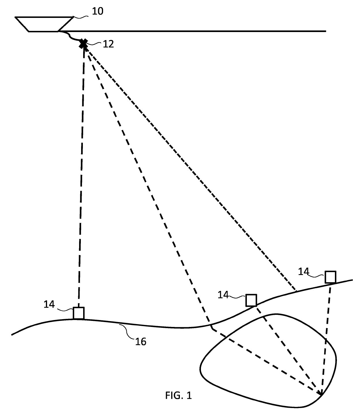
[0048]Referring to the drawings, wherein like reference numerals refer to like parts throughout, there is seen in FIG. 1 a boat 10 that is pulling an array of compressed air guns 12. Boat 10 is driven to traverse a grid of seismic nodes 14 that have been placed upon the ocean's floor 16 in a predetermined pattern. As boat 10 traverses atop the grid of nodes 14, shots of compressed air are emitted from gun 12 at predetermined intervals. The compressed air radiates downwardly through the water where the energy in the compressed air is ether directly received by each of the nodes 14 or refracts through the ocean floor 16 before reflecting back and reaching the nodes 14. It is the intention that for each shot of compressed air emitted by gun 12, the timing of the receipt of the shot and a corresponding energy level will be sensed and recorded in each of the nodes 14 regardless of whether the energy was directly received by each node 14 or received only after having been reflected / refrac...


PUM


Abstract

A computing system and method for determining the x, y energy receiver (node) positions regardless of the angle at which the energy was released from the source. The process and computing system involves an iterative looping technique that is executed in data processing software wherein an initial model position based on, in essence, a best guess as to a node's location, followed with the iterative process of statistically comparing model data to actual data and then adjusting the model position by some predetermined amount and comparing this new result to the actual data to determine if the newly adjusted position is statistically better or worse than the originally selected position assumption. The process can be repeated using continuously smaller distance adjustments to the previously determined best position. Once satisfied that the true best position has been achieved, the processing can cease and the XY position data may be used in the normal course of generating seismic maps.

Description

REFERENCE TO RELATED APPLICATION[0001]N / ABACKGROUND[0002]The present invention relates generally to seismic data acquisition and analysis gained through conducting a seismic survey, and more particularly to methodologies for improving the accuracy of the results based upon the seismic data analysis.[0003]The generation and recording of seismic data involves many different receiver configurations, including laying geophones or seismometers on the surface of the Earth or seafloor, towing hydrophones behind a marine seismic vessel, suspending hydrophones vertically in the sea or placing geophones in a wellbore (as in a vertical seismic profile) to record the seismic signal. A source, such as a vibrator unit, dynamite shot, or an air gun, generates acoustic or elastic vibrations that travel into the Earth, pass through strata with different seismic responses and filtering effects, and return to the surface to be recorded as seismic data. Optimal acquisition varies according to local con...

Claims


Application Information

Patent Timeline
Patent Type & Authority Patents(United States)
IPC IPC(8): G01V1/28G01V1/38
CPCG01V1/28G01V1/3835G01V1/38G01V2210/1427G01V1/20G01V1/30
Inventor UDENGAARD, CARSTEN
Owner MAGSEIS FF LLC
Why Eureka
Try Eureka