Airborne electromagnetic time domain system, computer product and method

a time domain and electromagnetic technology, applied in the field of airborne geological mapping, can solve the problems of secondary fields of electromagnetic currents that behave as noises, noise impacts survey data, and design airborne tdem systems based on priors, and achieve the effect of improving sensor resolution

Active Publication Date: 2005-01-06
EDWARD BEVERLY MORRISON +1
View PDF7 Cites 54 Cited by
  • Summary
  • Abstract
  • Description
  • Claims
  • Application Information

AI Technical Summary

Benefits of technology

[0021] An object of the present invention is to provide a TDEM system that provides improved sensor resolution.

Problems solved by technology

However, there are a number of technical problems in designing airborne TDEM systems based on prior art.
The secondary fields of these currents behave as a noise due to typical instability of the system geometry and thermal changes in conductors.
This noise impacts the survey data by generally decreasing their reliability for extrapolating geological data therefrom.
One of the disadvantages of these prior art solutions is that there is relatively poor horizontal resolution of the system due to the relatively long distance between transmitter coil and receiver sensor.
Another disadvantage is difficulties of system mechanical management in start / landing and in flight manoeuvres.
In turn, it leads to heavier frame construction.
In particular the heavier frame makes transportation of the bird difficult.
The production costs and fuel costs associated with manufacturing and use of the AEROTEM™ solution are also relatively high.
This generally results in insufficient transmitter dipole moment to make deeper measurements.
Another problem with the prior art solutions is that they do not easily permit exploiting optimal system geometry, that is the receiver in the centre of the transmitter coil.
But this relatively high voltage in turn renders the receiver preamp saturated and therefore inoperative during system measurement time for a short period after this pulse.
However, this then results in a departure from the optimal system geometry.
This rigid mounting precludes the proper vibration isolation of the receiver coil thus unwanted mechanical vibration influences the receiver coil so as to induce electrical interference thereby reducing sensitivity.
Another technical problem is how to produce maximum magnetic moment in the transmitter coil using minimum weight, size and electrical power.
Another problem is the air drag of the bird during flight.
Complicated support structures with large effective surface areas create excessive drag.
This limits possible flight speed increasing survey cost.
Another limitation of the previously mentioned systems is the limitation on the maximum transmitter diameter and therefore obtainable dipole moment.

Method used


Image

  • Airborne electromagnetic time domain system, computer product and method
  • Airborne electromagnetic time domain system, computer product and method
  • Airborne electromagnetic time domain system, computer product and method

Examples


Embodiment Construction

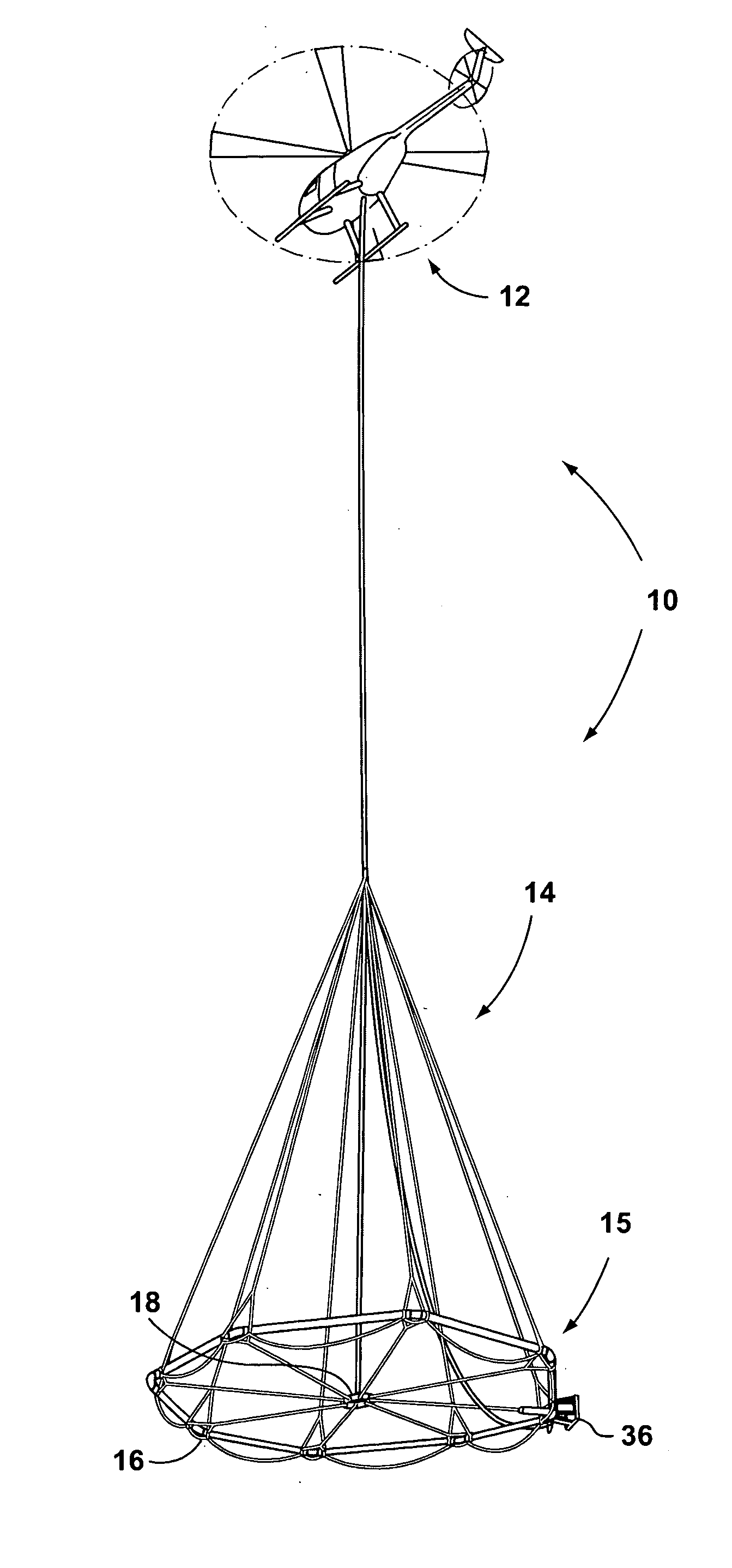
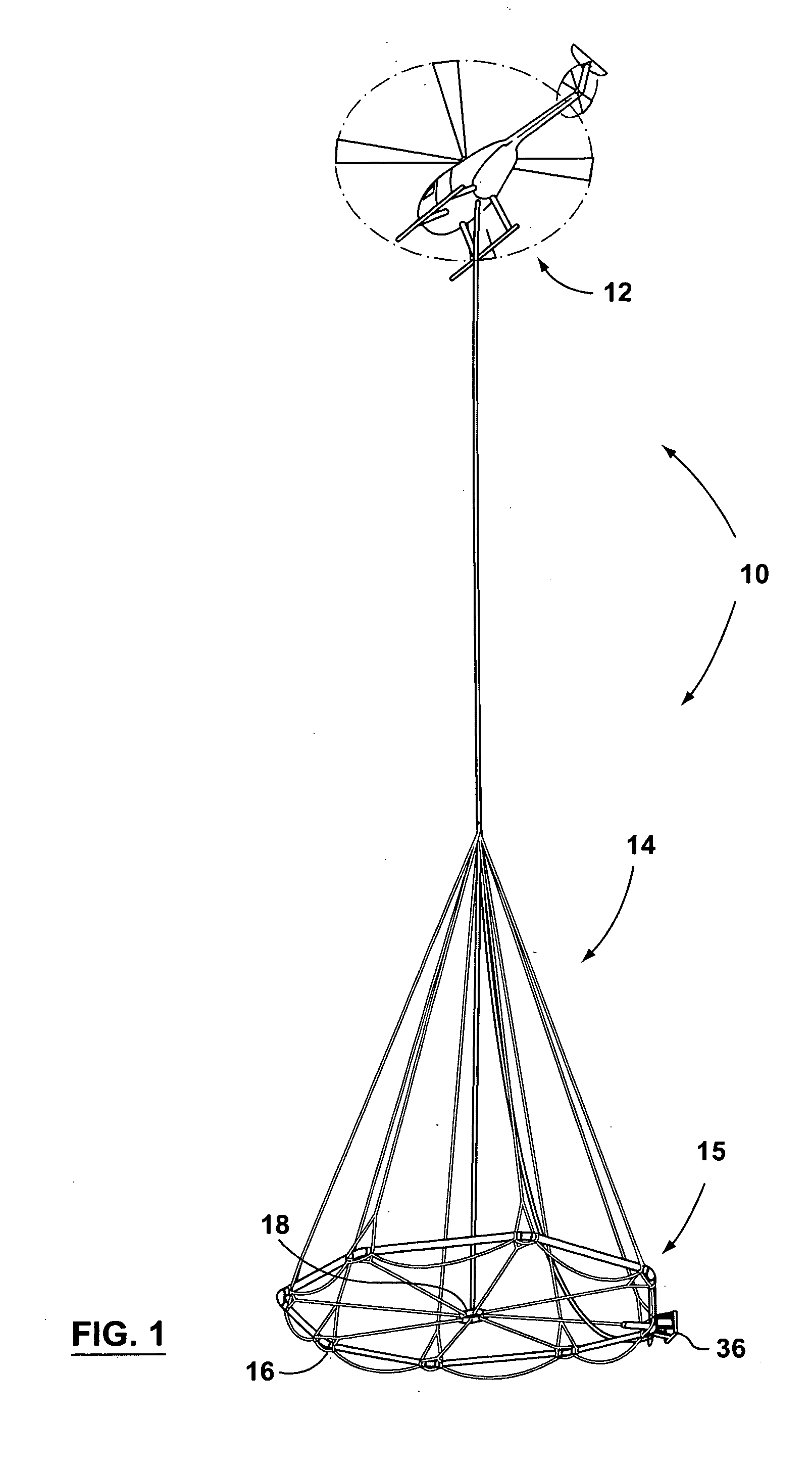
[0035] The present invention consists of an airborne TDEM survey system 10. The TDEM survey system 10 includes an aircraft 12 and a tow assembly 14. FIG. 1 illustrates an aircraft 12 that is a helicopter, however, other aircraft such as airplanes having desirable take-off and landing attributes from a geological survey perspective could also be used.

[0036] It should be understood that in one aspect of the present invention the tow assembly 14 is separate from the aircraft 12 but then attached thereto by a suitable attachment means. Provided that the flexible frame discussed below is provided, the tow assembly 14 could be integrated with an aircraft 12 to produce a geological surveying aircraft including a tow assembly 14 in accordance with the present invention.

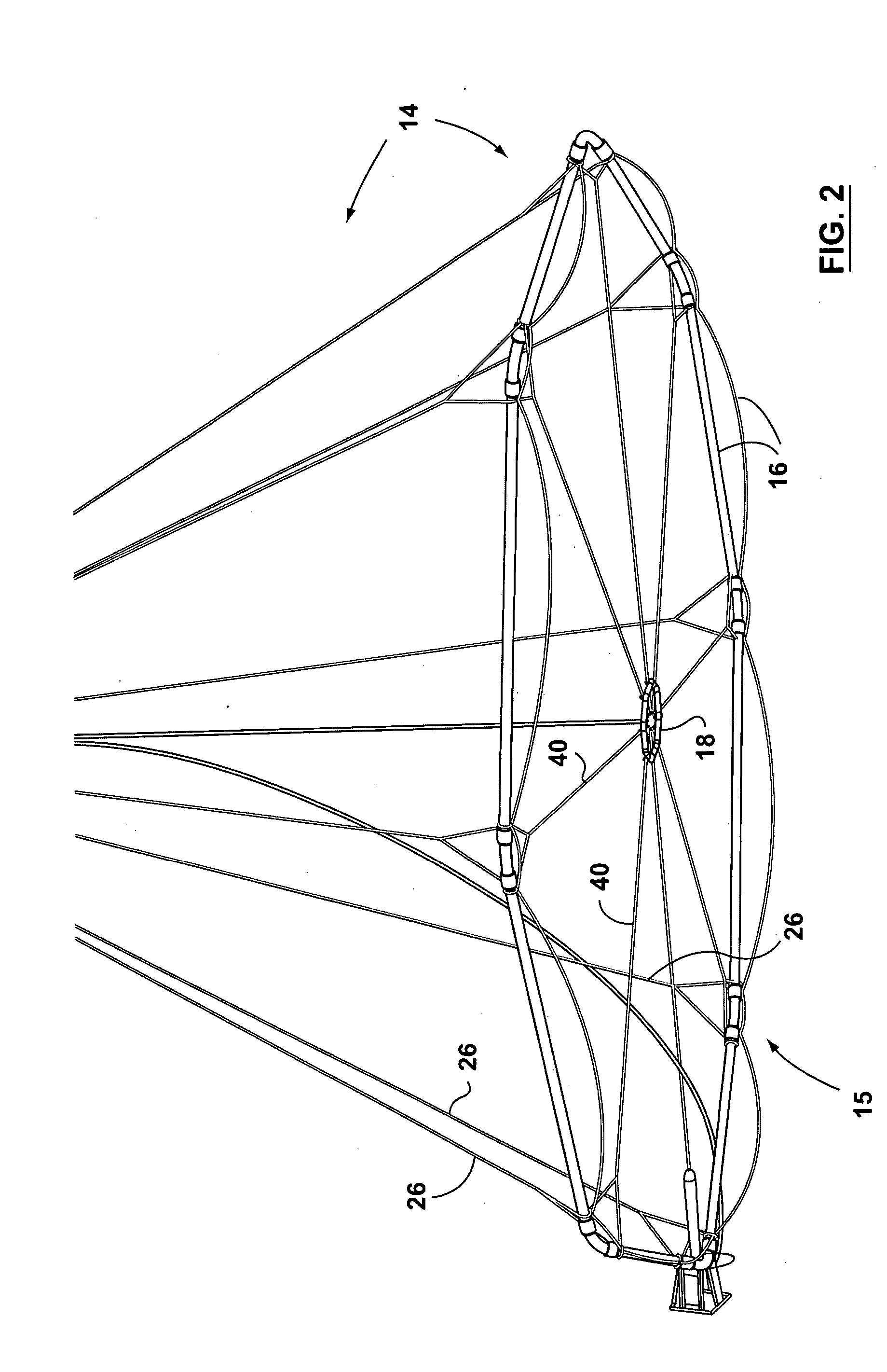
[0037] The tow assembly 14 of the present invention generally includes a flexible frame 15, as illustrated in FIG. 2. The flexible frame includes a transmitter section 16 and a receiver section 18. In accordance with the pr...


PUM


Abstract

An airborne time domain electromagnetic surveying system is provided. The system includes a tow assembly with a flexible support frame. The flexible support frame spaced apart from the aircraft includes a transmitter section with a transmitter loop and a receiver section with a sensor aligned with the central axis of the transmitter section. The flexible support frame has a lightweight modular structure that enables the surface area of the transmitter section to be increased and decreased to suit particular survey applications. The transmitter loop sends a pulse in an “ON” interval, and in an “OFF” interval the sensor measures the earth response to the pulse. The tow assembly also includes a sensor for generating selected survey data in the “ON” interval. A transmitter driver enables the creation of earthbound pulse. The system components are linked to a computer and control computer program linked thereto for controlling the functions thereof. The invention also includes a method for producing survey data using the tow assembly of the invention.

Description

FIELD OF THE INVENTION [0001] This invention relates in general to the field of airborne geological mapping. This invention further relates to an apparatus for conducting geological surveying using an electromagnetic time domain method. BACKGROUND OF THE INVENTION [0002] Time Domain Electromagnetic (TDEM) surveying is a rapidly developing area of geophysical surveying. It encompasses ground based and airborne applications. TDEM geological mapping involves equations for calculating the value of electromagnetic fields that are time dependent. Geological data is then inferred from the electromagnetic field data based on resistivity factors, in a manner that is known. [0003] The TDEM method was originally designed for exploration of conductive ore bodies buried in resistive bedrock, but at the present time it is also used extensively in general geological mapping, in hydrogeology, in environmental investigations etc. [0004] The method involves generating periodic magnetic field pulses p...

Claims


Application Information

Patent Timeline
Patent Type & Authority Applications(United States)
IPC IPC(8): G01V3/165
CPCG01V3/165Y02A90/30
Inventor MORRISON, EDWARD BEVERLYKUZMIN, PETR VALENTINOVICHTISHIN, PAVEL
Owner EDWARD BEVERLY MORRISON
Why Eureka
Try Eureka