System and method for calculating a navigation route based on non-contiguous cartographic map databases

a cartographic map and navigation route technology, applied in surveying, navigation, measurement devices, etc., can solve the problems of not being able conventional navigation devices were unable to provide such information, and cartographic data from one supplier does not match cartographic data from a different supplier

Inactive Publication Date: 2005-05-12
GARMIN
View PDF99 Cites 84 Cited by
  • Summary
  • Abstract
  • Description
  • Claims
  • Application Information

AI Technical Summary

Benefits of technology

[0018] The navigation route calculating method transitions from one map database to another, during a route planning search, each time a potential path intersects a boundary of a map database. To effect a transition from a current map database, the method first searches other map databases at the present tier, (e.g., assigned to the same ti...

Problems solved by technology

Hence, for long trips, the route planning and navigation device only utilizes the base map and thus is only able to offer limited information regarding the details of a planned route.
Due to memory constraints, the base map database includes less detailed feature information and may lack feature information surrounding the source and destination locations of interest to the user.
If the user desired detailed street information for Kansas City, for example, directions to Arrowhead Stadium, conventional navigation devices were unable to provide such information while simultaneously providing a route between cities since the street information was only on detailed map database...

Method used


Image

  • System and method for calculating a navigation route based on non-contiguous cartographic map databases
  • System and method for calculating a navigation route based on non-contiguous cartographic map databases
  • System and method for calculating a navigation route based on non-contiguous cartographic map databases

Examples


Embodiment Construction

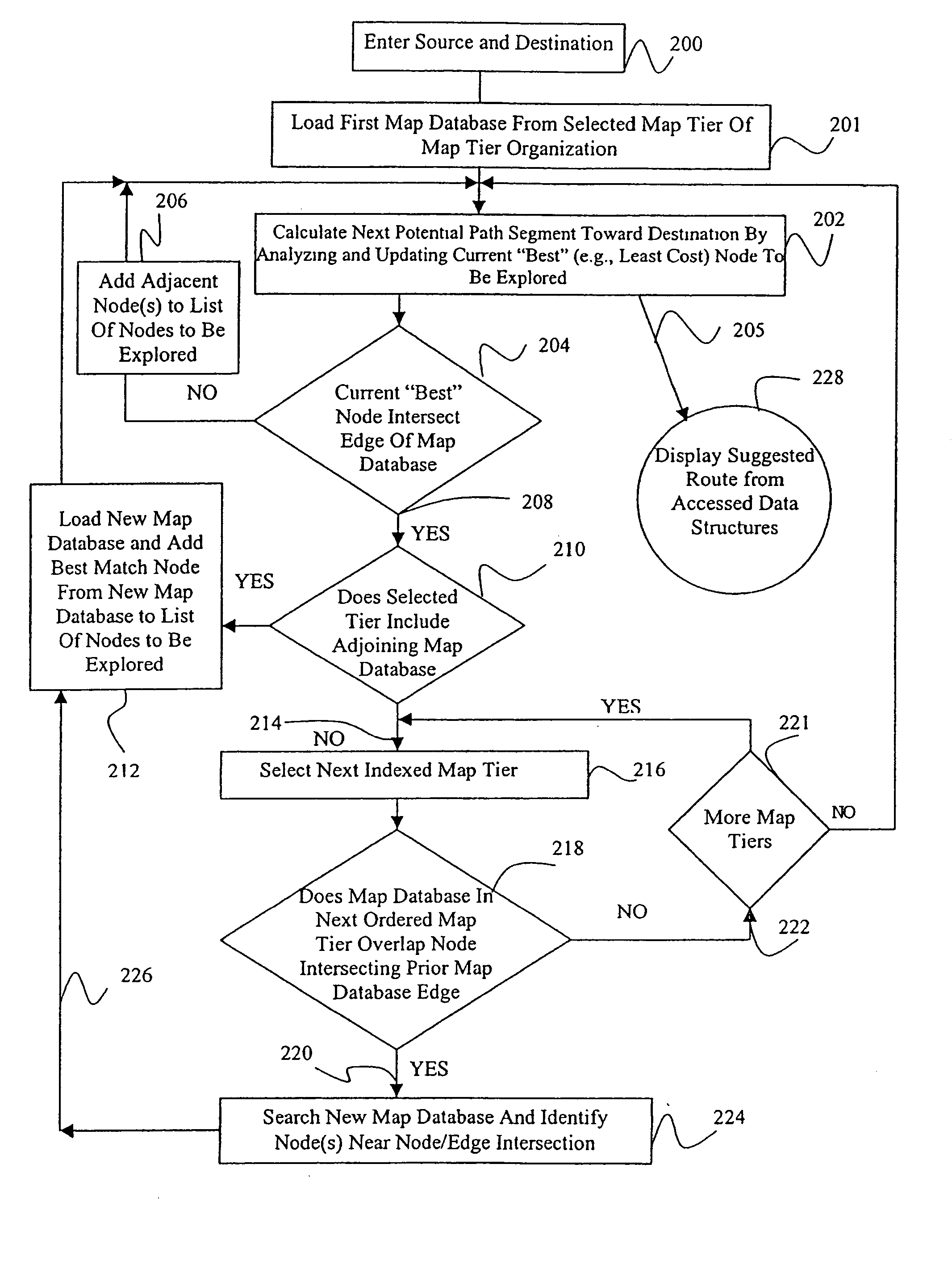
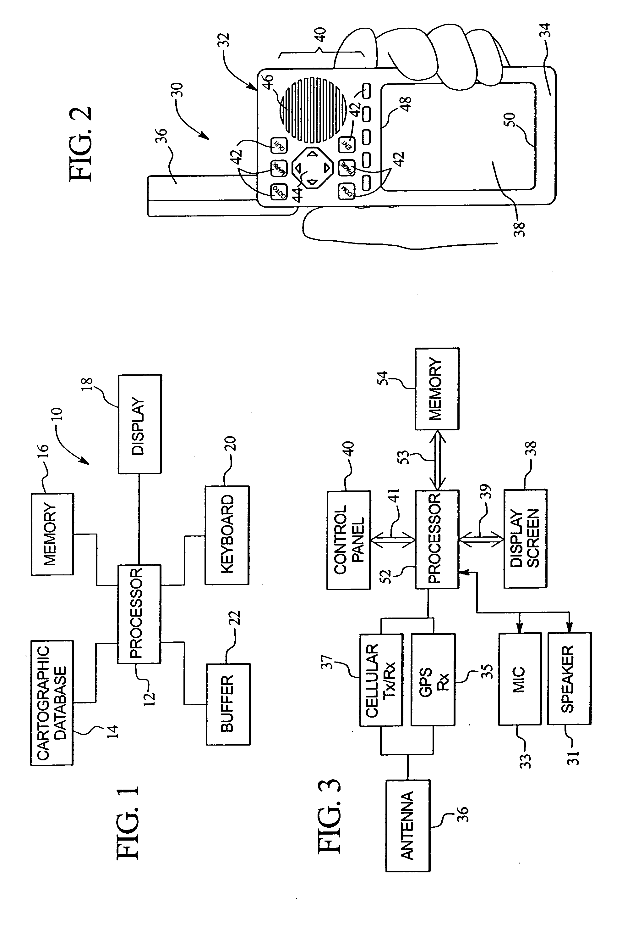
[0037]FIG. 1 illustrates a system 10 formed in accordance with an embodiment of the present invention. The system 10 includes at least one processor 12 for carrying out various processing operations discussed below in more detail. The processor 12 is connected to a cartographic database 14, memory 16, a display 18, a keyboard 20, and a buffer 22. Optionally, more than one processor 12 may be included. The cartographic database 14 may store data indicative of a roadway network (in full or in part) used in connection with embodiments of the present invention. The memory 16, while illustrated as a single block, may comprise multiple discrete memory locations and / or discs for storing various types of routines and data utilized and / or generated by embodiments of the present invention. The buffer 22 represents a memory storage area that may be within memory 16 or separate therefrom. Buffer 22 is used to temporarily store data and / or routines used in connection with embodiments of the pres...


PUM


Abstract

A method and apparatus are provided for calculating potential paths between source and destination locations. First and second map databases are provided that are indicative of roadway networks for geographic regions bounded by region edges and containing source and destination locations. The first and second map databases are non-adjacent, non-contiguous such that the region edges of the first map database are separate and distinct from region edges of the second map database. Potential paths are calculated through the roadway network of the first map database up to a node or segment at which each potential path intersects a region edge of the first map database, thereby defining a node/edge coordinate. A transition location is obtained in the second map database that geographically corresponds to the node/edge coordinate at which a given potential path intersected the region edge of the first map database. The calculation continues from the transition location through the roadway network of the second map database. The method and apparatus may include organizing the map databases into a map hierarchy to define tiers for the map databases. The calculation process searches potential paths utilizing the tier-one map databases until each potential path intersects a map edge of the tier-one map databases. Thereafter, the search through potential paths continues automatically based on the lower tier map databases.

Description

RELATED APPLICATIONS [0001] The present application is a continuation and claims priority benefit, with regard to all common subject matter, of an earlier-filed U.S. patent application titled “SYSTEM AND METHOD FOR CALCULATING A NAVIGATION ROUTE BASED ON NON-CONTIGUOUS CARTOGRAPHIC MAP DATABASES”, Ser. No. 10 / 423,658, filed Aug. 11, 2003, which is a continuation and claims priority benefit, with regard to all common subject matter, of an earlier-filed U.S. patent application titled “SYSTEM AND METHOD FOR CALCULATING A NAVIGATION ROUTE BASED ON NON-CONTIGUOUS CARTOGRAPHIC MAP DATABASES”, Ser. No. 10 / 015,153, filed Dec. 11, 2001, now U.S. Pat. No. 6,574,554. The identified earlier-filed applications are hereby incorporated into the present application.BACKGROUND OF THE INVENTION [0002] Certain embodiments of the present invention generally relate to systems and methods for calculating navigation routes based on map databases indicative of overlapping, non-contiguous geographic regions...

Claims


Application Information

Patent Timeline
IPC IPC(8): G01C21/30G01C21/34
CPCG01C21/30G01C21/3446G01C21/34
Inventor BEESLEY, DARIN J.CHILDS, MICHAEL
Owner GARMIN
Why Eureka
Try Eureka