Method for differentiating duplicate or similarly named disjoint localities within a state or other principal geographic unit of interest

a geographic unit or state, duplicate or similarly named technology, applied in the field of map databases, can solve the problems of inability to effectively condense similar names for a locality into a single entry, and the approach is not particularly useful or robust in identifying similarly named yet disjoint localities for navigation applications

Active Publication Date: 2007-09-06
TOMTOM GLOBAL CONTENT
View PDF9 Cites 12 Cited by
  • Summary
  • Abstract
  • Description
  • Claims
  • Application Information

AI Technical Summary

Problems solved by technology

One problem occurs when a user requests a location having a locality name that is a duplicate of another locality name yet disjoint from the other locality name.
Currently, map databases are unable to effectively condense similar names for a locality into a single entry.
This approach is not a particularly useful or robust method of distinguishing similarly named yet disjoint localities for navigation applications.

Method used


Image

  • Method for differentiating duplicate or similarly named disjoint localities within a state or other principal geographic unit of interest
  • Method for differentiating duplicate or similarly named disjoint localities within a state or other principal geographic unit of interest
  • Method for differentiating duplicate or similarly named disjoint localities within a state or other principal geographic unit of interest

Examples


Embodiment Construction

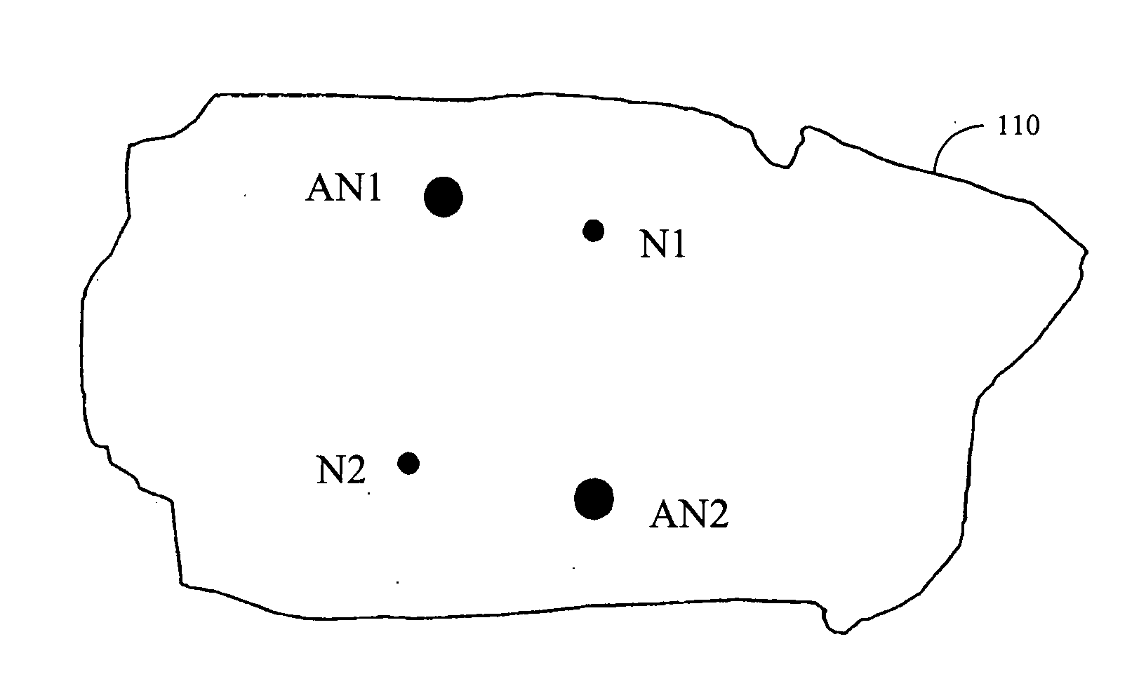
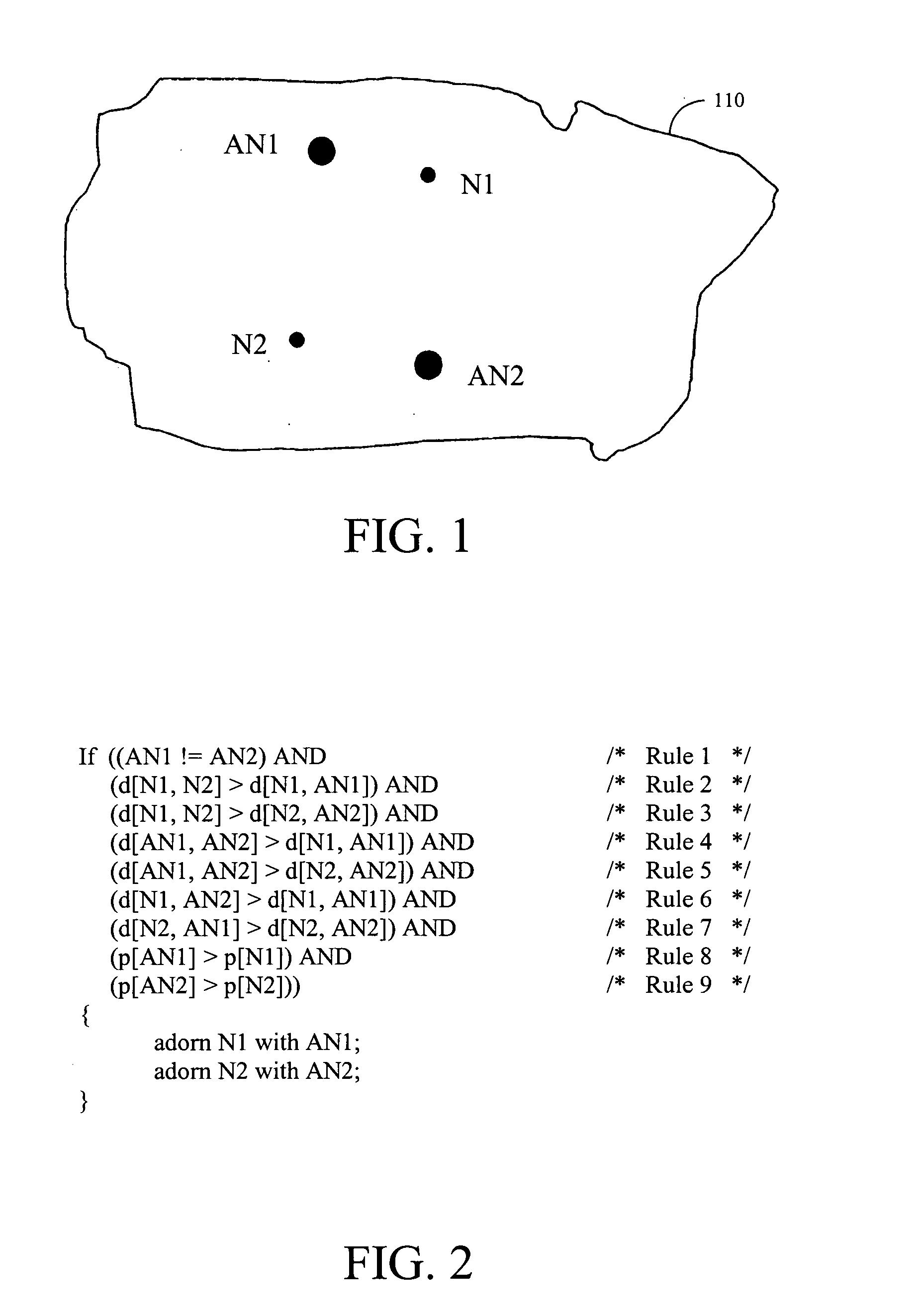
[0020]FIG. 1 illustrates an example of two duplicate yet disjoint localities, N1 and N2, in a fictitious principal geographic unit of interest 110, as well as example significant nearby localities, AN1 and AN2, which adorn localities N1 and N2, respectively. The adornment process is provided in more detail in the following discussion of the other figures.

[0021]FIG. 2 illustrates an embodiment of the rules involved for selecting adornments AN1 and AN2 for a pair of duplicate localities N1 and N2, respectively, within a geographic unit of interest. Many algorithms for determining the adornments for N1 and N2 are possible. Both AN1 and AN2 are located in the same geographic unit of interest as N1 and N2. Embodiments of the invention adorn localities with more helpful names of nearby big cities or other significant localities. As shown in FIG. 2, the function d[ ] returns the distance between two localities and the function p[ ] determines the significance of a locality name. According...


PUM


Abstract

A method and system for differentiating duplicate yet disjoint localities, such as cities, within a state or other principal geographic unit of interest is for use with electronic maps and databases. Duplicate locality name entries are stored in a database, locality name database entries are condensed for localities having two or more similar names, and adornments for duplicate locality names are stored in the database. In the adornment selection process, for a first duplicate locality, a second duplicate locality is selected that is closest to the first. Selected adornments are first and second significant localities, such as large cities, and are closer to the first and second duplicate localities, respectively, than the first and second duplicate localities are to each other, and are more significant than the first and second duplicate localities. Adornments to duplicate localities are displayed to the user. The process is repeated for remaining duplicate localities.

Description

FIELD OF THE INVENTION [0001] The present invention relates to map databases having information for determining localities and, more particularly, to map databases having a data structure that is used for differentiating duplicate or similarly named disjoint localities for a location desired by a user. BACKGROUND OF THE INVENTION [0002] In recent years, consumers have been provided with a variety of devices and systems to enable them to locate specific street addresses on a digital map. These devices and systems are in the form of in-vehicle navigation systems that enable drivers to navigate over streets and roads, portable hand-held devices such as personal digital assistants (“PDAs”), personal navigation devices and cell phones that can do the same, and Internet applications in which users can generate maps showing desired locations. The common aspect in all of these and other types of devices and systems is a map database of geographic features and software to access and manipula...

Claims


Application Information

Patent Timeline
Patent Type & Authority Applications(United States)
IPC IPC(8): G06F7/00G06F17/30
CPCG06F17/30241G06F16/29
Inventor GEILICH, MICHAEL
Owner TOMTOM GLOBAL CONTENT
Why Eureka
Try Eureka