
Methods and apparatus for providing map locations in user applications using URL strings

a technology of user applications and map locations, applied in web data retrieval, data processing applications, instruments, etc., can solve the problems of limited memory and processing power of mobile communication devices, limited visual display maps for computer devices, and limited memory and processing power

Active Publication Date: 2007-10-04
MALIKIE INNOVATIONS LTD
View PDF12 Cites 80 Cited by
  • Summary
  • Abstract
  • Description
  • Claims
  • Application Information

AI Technical Summary

Benefits of technology

The present patent relates to methods and apparatus for providing map locations in computer devices, particularly mobile communication devices, by fully exploiting the capabilities of such devices and minimizing memory and communication bandwidth resources. The invention allows for the efficient use of mapping applications in mobile devices by receiving an electronic file or message with a hypertext link mapping indicator associated with a URL string and invoking a mapping function of the mapping application or requesting map data from a map coordinating server. The technical effects include improved user experience and efficient use of device resources.

Problems solved by technology

Traditionally, visually displayed maps for computer devices have been limited to those based on bitmap images which are relatively large files.
Mobile communication devices, which typically operate with use of one or more batteries or battery packs, however, typically have relatively limited memory and processing power as compared to larger computer devices such as personal computers (PCs) or even laptop computers.

Method used


Image

  • Methods and apparatus for providing map locations in user applications using URL strings
  • Methods and apparatus for providing map locations in user applications using URL strings
  • Methods and apparatus for providing map locations in user applications using URL strings

Examples


Embodiment Construction

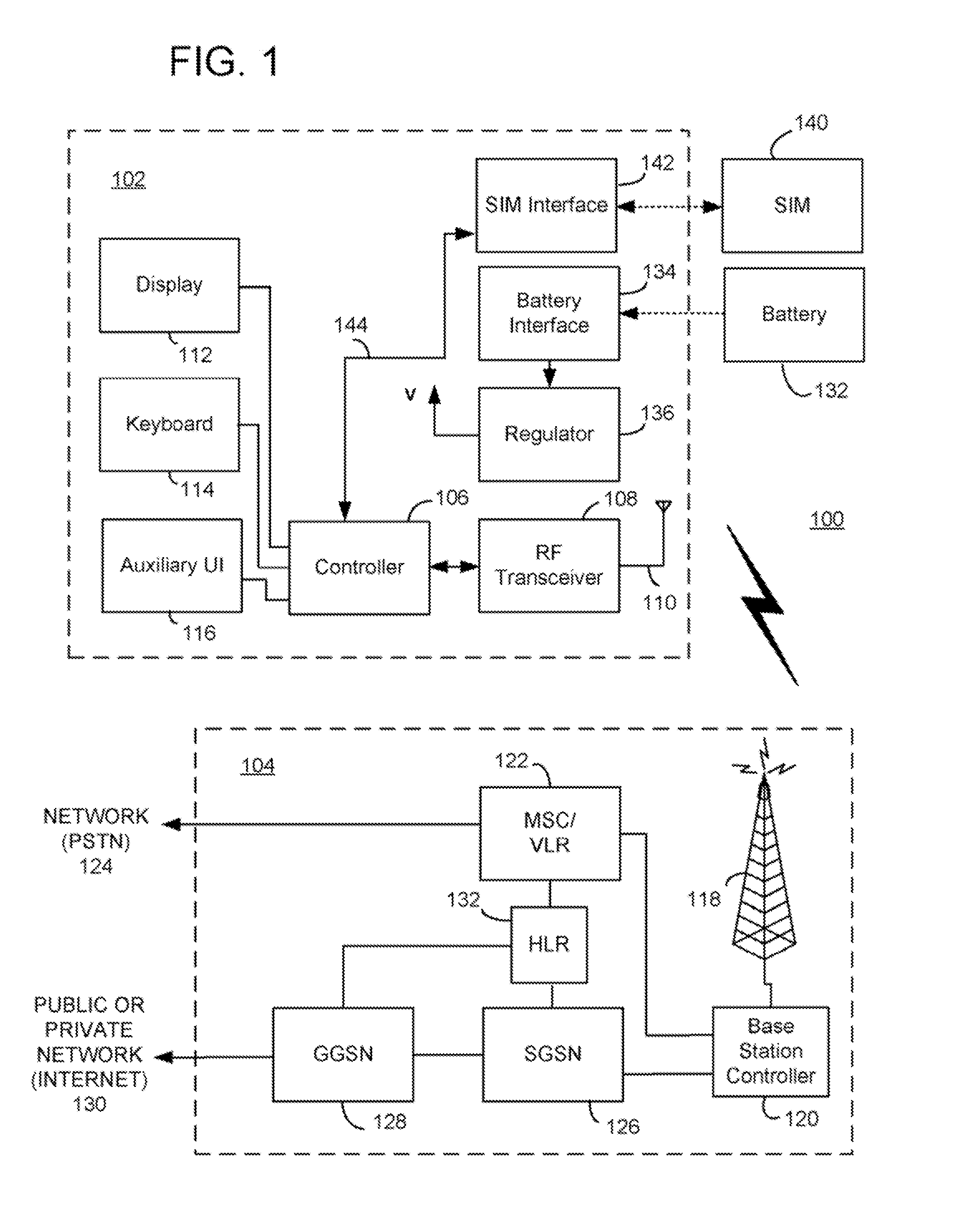
[0026] Methods and apparatus for use in mapping a location in a computer device are described herein. In one illustrative example, the method includes the steps of receiving an electronic file or message which includes a hypertext link mapping indicator associated with a uniform resource locator (URL) string having a server address and latitude and longitude coordinates; receiving, through a user interface of the computer device, an end user selection of the hypertext link mapping indicator in the electronic file or message; and in response to the end user selection of the hypertext link mapping indicator: if a predetermined type of mapping application is provided in the computer device, invoking a mapping function of the mapping application to produce a map of a location corresponding to the latitude and longitude coordinates for visual display in a display of the computer device (e.g. based on received maplet data); and if the predetermined type of mapping application type is not ...


PUM


Abstract

In one illustrative example, a method for use in mapping a location in a computer device includes the steps of receiving an electronic file or message which includes a hypertext link mapping indicator associated with a uniform resource locator (URL) string having a server address and latitude and longitude coordinates; receiving, through a user interface of the computer device, an end user selection of the hypertext link mapping indicator in the electronic file or message; and in response to the end user selection of the hypertext link mapping indicator: if a predetermined type of mapping application is provided in the computer device, invoking a mapping function of the mapping application to produce a map of a location corresponding to the latitude and longitude coordinates for visual display in a display of the computer device (e.g. based on received maplet data); and if the predetermined type of mapping application type is not provided in the computer device, requesting and receiving map data from a map coordinating server identified by the server address of the URL string to produce a map of the location for visual display in the display (e.g. based on a bitmap image). Advantageously, processing of the received hypertext link mapping indicator is handled differently depending on the type of device or whether a predetermined mapping application is installed in the device, so that optimal mapping functionality is provided for different device environments.

Description

CROSS-REFERENCE TO RELATED APPLICATIONS [0001] This application claims priority to U.S. provisional patent application of the same title having Ser. No. 60 / 787,872, docket number 0108-0321 / US, and filing date of 31 Mar. 2006, and to a U.S. provisional patent application entitled “Method And System For Distribution Of Map Content To Mobile Communication Devices” having Ser. No. 60 / 787,541, docket number P1579US00 (also RIM 30176-ID), lead inventor Eric Johnson, and a filing date of 31 Mar. 2006.BACKGROUND [0002] 1. Field of the Technology [0003] The present disclosure relates generally to providing map locations in user applications for the visual display of maps in computer devices including mobile communication devices. [0004] 2. Description of the Related Art [0005] Increasingly, mobile communication devices operating in wireless communication networks are provided with mapping capabilities for presenting visually displayed maps of geographic locations. Traditionally, visually dis...

Claims


Application Information

Patent Timeline
Patent Type & Authority Applications(United States)
IPC IPC(8): G06F17/30H04M1/72406
CPCG01C21/20G01C21/26G06F17/3087G06F17/30876G09B29/106G06F17/30882H04L61/30H04L67/18Y10S707/919Y10S707/92H04L29/12594G06F16/29G06F16/955G06F16/9537G06F16/9558G06F16/9566H04W4/02H04L67/52H04M1/72406H04L61/4511H04L61/3025
Inventor BOUDREAU, JESSEDICKE, RONALD
Owner MALIKIE INNOVATIONS LTD
Learn More