
Global navigation satellite system

a satellite system and global navigation technology, applied in the field of communication systems, can solve the problems of inability to achieve the desired effect, requires sufficient satellite signal strength, and takes a relative long tim

Active Publication Date: 2008-04-17
QUALCOMM INC
View PDF10 Cites 37 Cited by
  • Summary
  • Abstract
  • Description
  • Claims
  • Application Information

AI Technical Summary

Problems solved by technology

The amount of bias depends on the actual GGTO, and may be acceptable in certain scenarios, but of course, is less desirable.
The GGTO may be obtained by decoding the satellite navigation message (which however, requires sufficient satellite signal strength and takes a relative long time; i.e., increases the TTFF), or may be provided in the assistance data message (which however, requires modifications to standardized location protocols).
However, handling the various different system times and time offsets in the navigation solution requires substantial modifications to existing user receivers, and would undoubtedly raise the costs associated with production of next generation user receivers having this capability.

Method used


Image

  • Global navigation satellite system
  • Global navigation satellite system
  • Global navigation satellite system

Examples


Embodiment Construction

[0041] The following description and drawings are illustrative of the invention and are not to be construed as limiting the invention. Numerous specific details are described to provide a thorough understanding of the present invention. However, in certain instances, well-known or conventional details are not described in order to avoid obscuring the description of the present invention. References to one embodiment or an embodiment in the present disclosure are not necessarily to the same embodiment, and such references include one or more embodiments.

Communication System 10

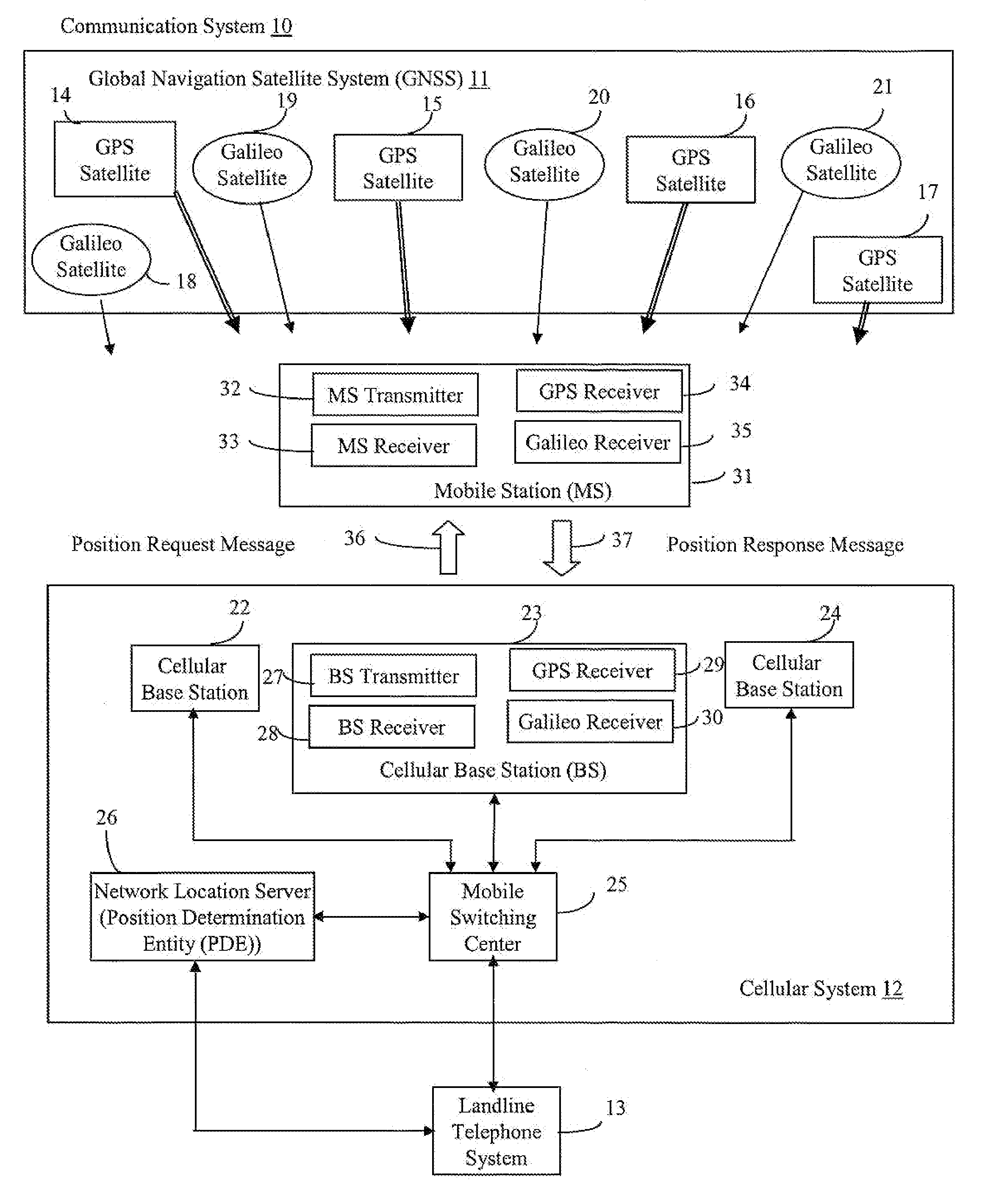
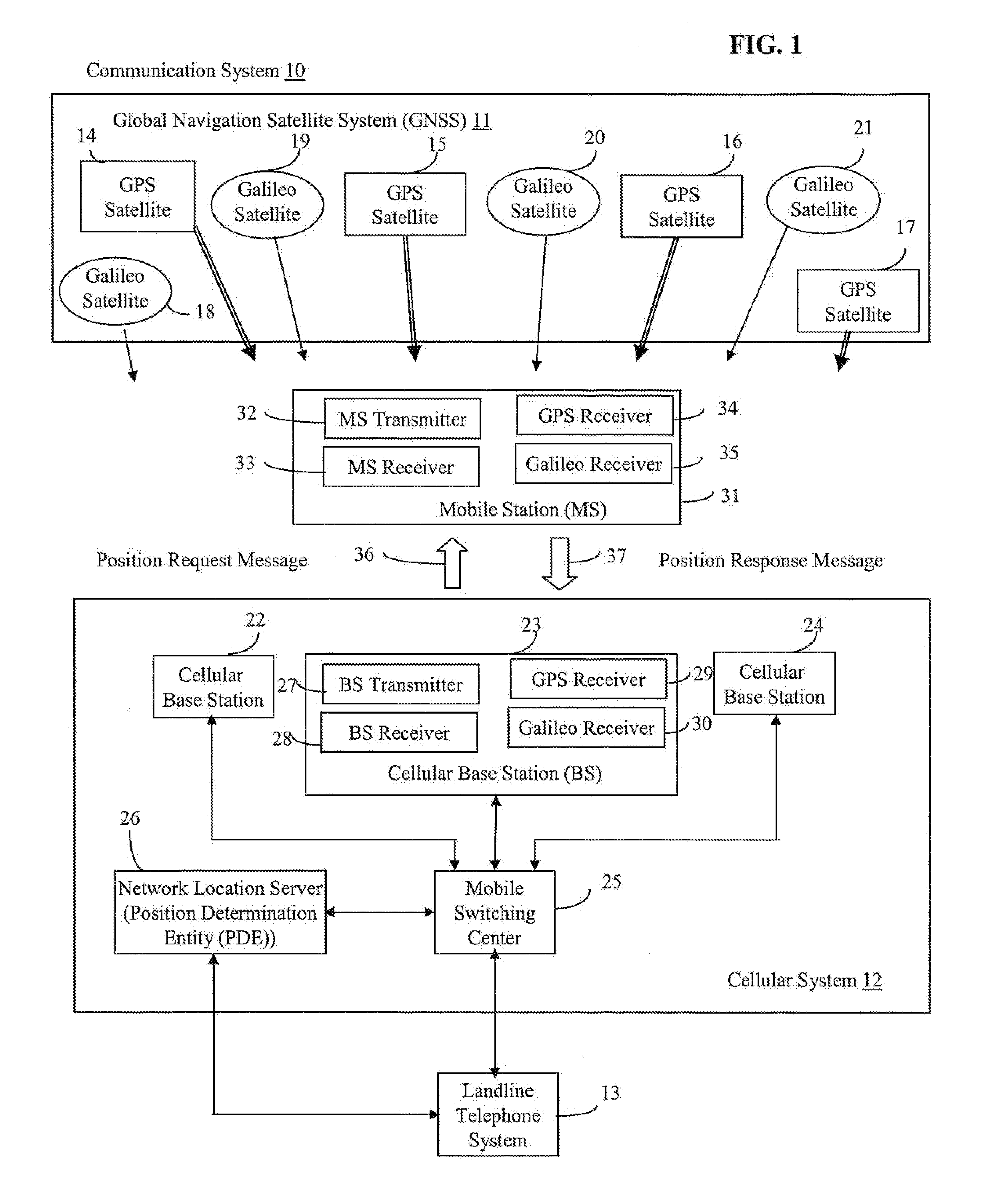
[0042]FIG. 1 illustrates a block diagram representation of a communication system 10, including a global navigation satellite system (GNSS) 11, a cellular system 12, a landline telephone system 13, according to one aspect of the present invention. The GNSS system 11 includes multiple global navigation satellites 14-21, including a first set of satellites 14-17 associated with a first GNSS and a second set of s...


PUM


Abstract

Each of a first and a second navigation satellite system (NSS) are adapted to operate according to a first and a second specification, respectively, and each includes a first and a second plurality of space vehicles (SV), respectively. Each of the first and the second plurality of SVs are adapted to be identified by a first and a second plurality of unique corresponding identifications (IDs), respectively. A processor is adapted to receive and identify a first plurality of corresponding signals transmitted from the first plurality of SVs in response to the first plurality of unique corresponding IDs. The processor is adapted to receive and identify a second plurality of corresponding signals transmitted from the second plurality of SVs in response to the second plurality of unique corresponding IDs. The processor is adapted to determine position location information in response to receiving and identifying the first plurality of corresponding signals and the second plurality of corresponding signals.

Description

CROSS-REFERENCE TO RELATED APPLICATIONS [0001] The present application claims priority to U.S. Provisional Application No. 60 / 782,955, filed on Mar. 15, 2006 entitled, “Virtual GNSS Time,” which is assigned to the assignee hereof and which is incorporated herein by reference. The present application is a continuation-in-part of U.S. application Ser. No. 11 / 621,935, filed on Jan. 10, 2007, entitled “Global Navigation Satellite System”, which is assigned to the assignee hereof and which is incorporated herein by reference.FIELD OF THE INVENTION [0002] The present invention generally relates to communication systems. More particularly, the present invention relates to a communication system including a global navigation satellite system. BACKGROUND OF THE INVENTION [0003] There are many different types of technologies employed in calculating the location of mobile stations in wireless networks with various levels of success and accuracy. Assisted-GPS (A-GPS) is a positioning technology...

Claims


Application Information

Patent Timeline
Patent Type & Authority Applications(United States)
IPC IPC(8): H04B7/185G01S19/05
CPCG01S19/33G01S19/05G01S19/256G01S19/30
Inventor FISCHER, SVEN
Owner QUALCOMM INC
Learn More