Method For Setting an Aircraft Barometric Altitude

a barometric altitude and aircraft technology, applied in vehicle position/course/altitude control, process and machine control, instruments, etc., can solve the problems of increasing noise nuisance, reducing the crossing margin, and lowering the approach minima

Inactive Publication Date: 2008-10-02
THALES SA
View PDF2 Cites 26 Cited by
  • Summary
  • Abstract
  • Description
  • Claims
  • Application Information

AI Technical Summary

Benefits of technology

[0019]The method is an aid for operating towards isolated airfields whose air traffic organization is not in post, thus making it possible to lower the approach minima. The decision altitude for certain approaches can vary according to the knowledge or otherwise of the local atmospheric pressure. For geographical areas where the QNH is available, the method is then a means of verifying the altimetric setting in the approach phase.
[0020]The method ensures an alert when the altitude determined appears unambiguously different from the altitude measured by barometric means which is dependent on the QNH displayed by the pilot. The method allows the semi-automatic setting of the QNH during the approach after pilot confirmation. The method can ensure automatic setting without outside intervention for example in the case of pilotless aircraft called drones.

Problems solved by technology

The causes of altimetric setting errors can stem from erroneous acquisition of the reference pressure, its erroneous display on the altimeters or failure to perform the change of altimetric setting according to the phase of the flight.
The consequences of an erroneous altimetric setting are notably:overflying of obstacles at a lower height than is prescribed by the procedure, reducing the crossing margin;overflying of the obstacles at a greater height than is prescribed by an approach procedure, thereby giving rise to an erroneous approach plan that may involve difficulties in reducing the speed for final approach;overflying of built-up areas at a lower height than is prescribed by the procedure, increasing sound nuisance.transmission of erroneous altitude information from the aircraft to a control organization in charge of traffic information in air space not covered by a radar.transmission of erroneous altitude information from the aircraft, to another aircraft during an inter-aircraft separation operation in an auto-information sector.penetration into a restricted or forbidden area due to wrong reading of the altitude.
This manual operation is a source of error both at the level of the understanding of the information received and the input to the altimeter.

Method used


Image

  • Method For Setting an Aircraft Barometric Altitude
  • Method For Setting an Aircraft Barometric Altitude
  • Method For Setting an Aircraft Barometric Altitude

Examples


Embodiment Construction

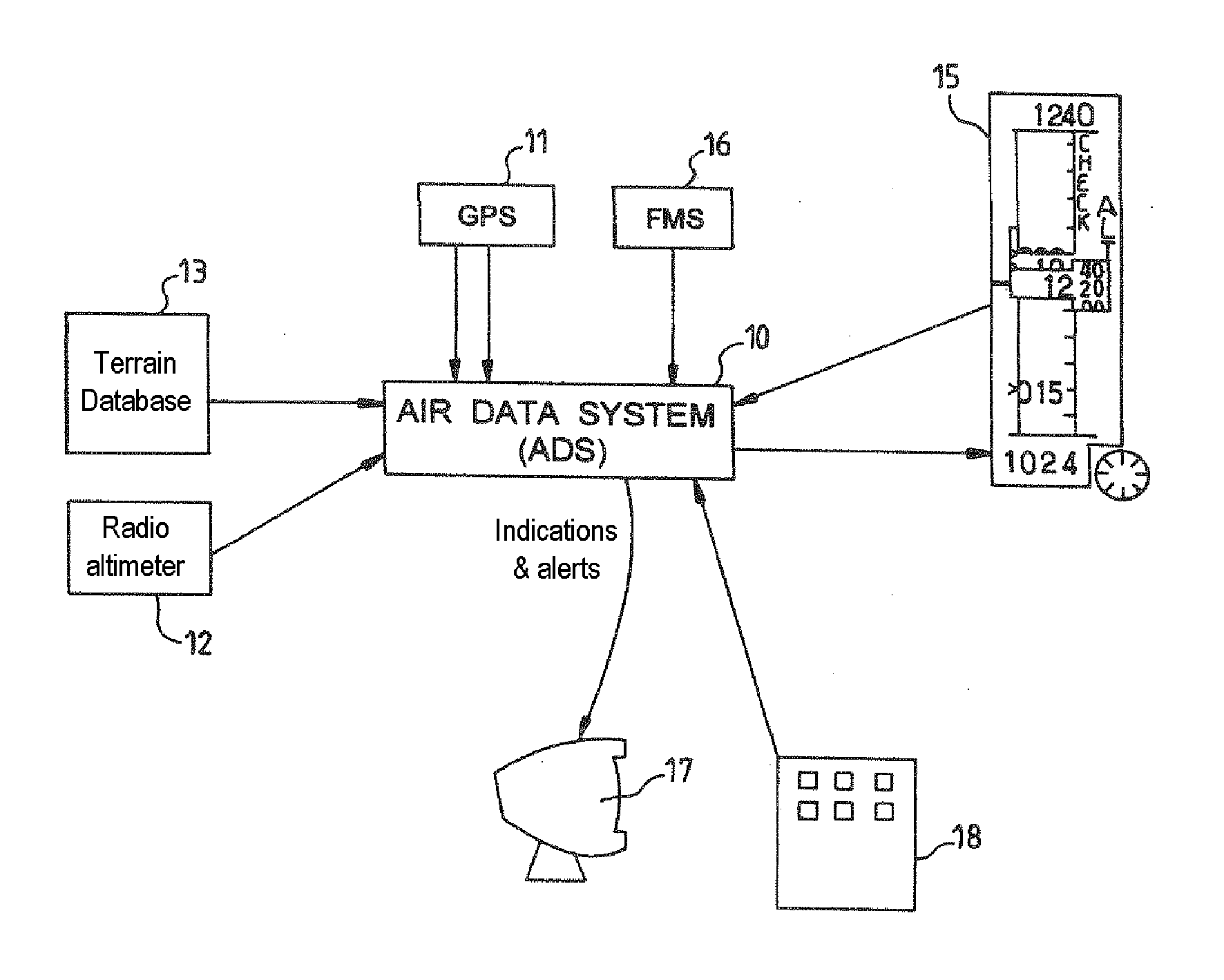
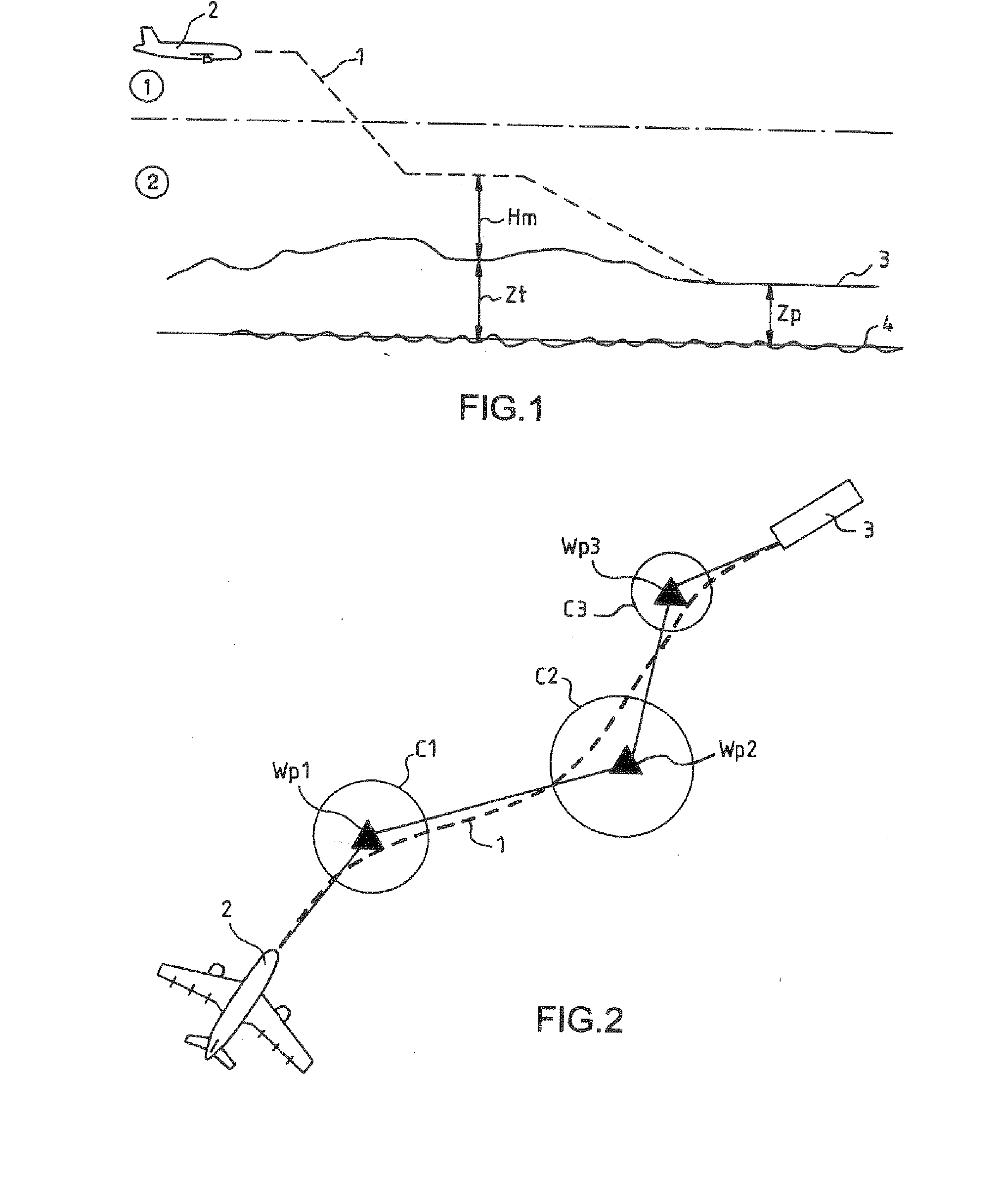
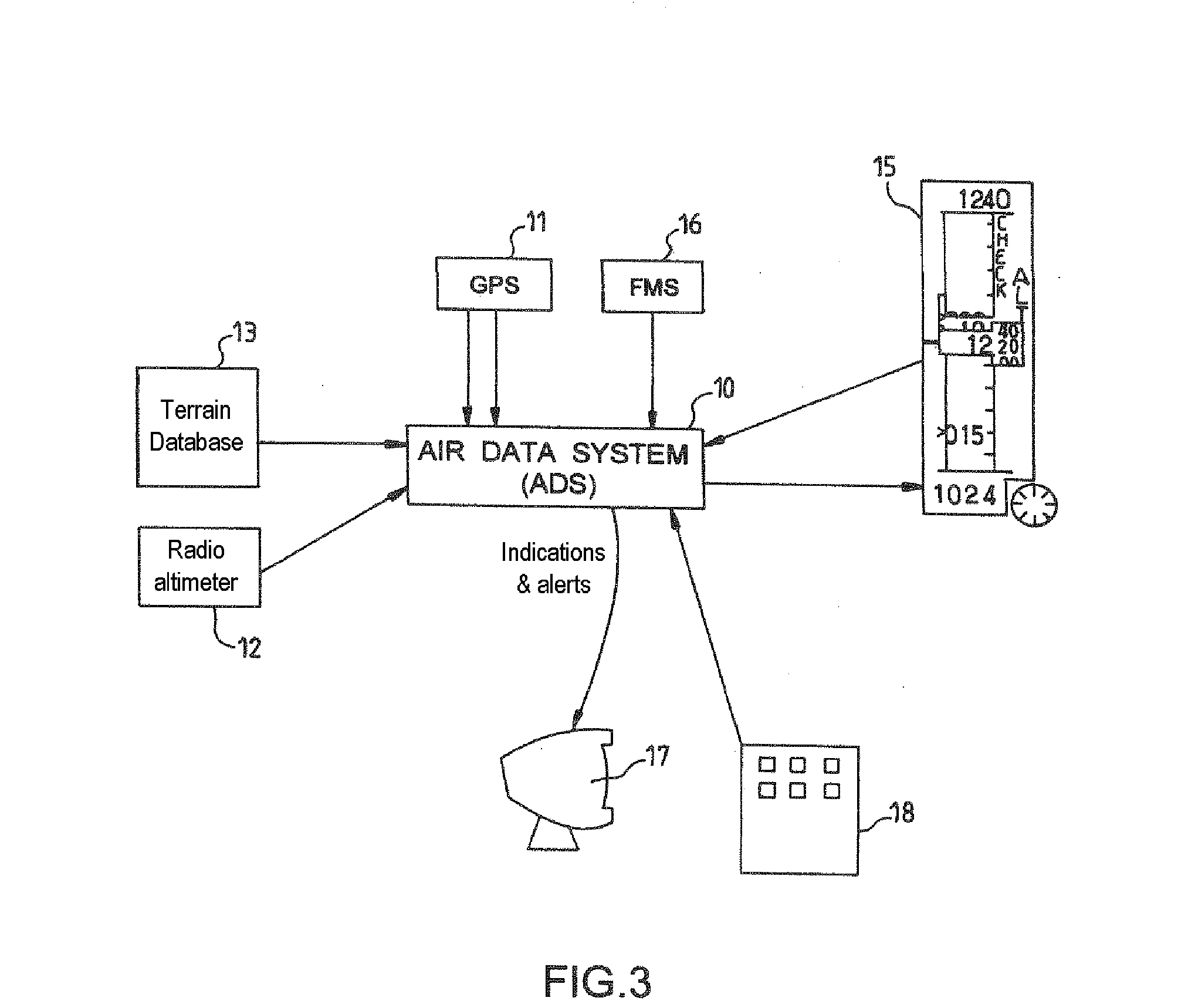
[0028]FIG. 1 represents as a broken line the trajectory 1 of an aircraft 2 in the approach to a runway 3 situated at an altitude Zp relative to sea level 4. The aircraft is equipped with two means for determining the altitude not using the barometric pressure, such as satellite navigation means, a GPS system for example, as well as radio altimetry means. The latter means have a limited range. They cannot perform measurement beyond 2500 feet or indeed 4000 feet for recent radio altimetry means. It is recalled that a foot equals 0.33 m. Subsequently in the description the altitudes will be expressed in feet as customary in the aeronautical sector. In a first phase {circle around (1)} of flight, beyond the range of the radio altimetry means, only the GPS system makes it possible to determine the altitude as a complement of means for measuring the barometric pressure, means also present aboard the aircraft. The GPS system determines the altitude of the aircraft as well as the precision ...


PUM


Abstract

The invention relates to a method for aiding the setting of the barometric altitude of an aircraft equipped with a means (11, 12) for determining the altitude not using the barometric pressure, determining with the aid of the means (11, 12) for determining the altitude an altitude (Zv, Zi, Zr, Zh) and its relative precision (Pzv, Pzr), comparing the determined altitude (Zv, Zi, Zr, Zh) with a barometric altitude measured aboard the aircraft, generating an alert when the discrepancy between the determined altitude (Zv, Zi, Zr, Zh) and the measured barometric altitude exceeds a predefined value and proposing a barometric altitude setting value.

Description

CROSS-REFERENCE TO RELATED APPLICATIONS[0001]The present Application is based on International Application No. PCT / FR2006 / 002404, filed on Oct. 24, 2006, which in turn corresponds to French Application No. 05 10874, filed on Oct. 25, 2005, and priority is hereby claimed under 35 USC §119 based on these applications. Each of these applications are hereby incorporated by reference in their entirety into the present application.FIELD OF THE INVENTION[0002]The invention relates to a method for aiding the setting of the barometric altitude of an aircraft.BACKGROUND OF THE INVENTION[0003]The conduct of a flight requires the use of various settings of the barometric altitude. Departure and arrival take place in the low atmospheric layers using an altitude reference or local height reference to pinpoint the aircraft in the vertical plane. The remainder of the flight from climb to arrival use a standard altimetric reference facilitating inter-aircraft spacing. The change of altimetric refere...

Claims


Application Information

Patent Timeline
Patent Type & Authority Applications(United States)
IPC IPC(8): G06F17/00
CPCG01C5/06G01C25/00
Inventor SACLE, JEROMECOULMEAU, FRANCOIS
Owner THALES SA
Why Eureka
Try Eureka