
Method and Server Computer For Generating Map Images For Creating Virtual Spaces Representing The Real World

a server computer and virtual space technology, applied in the field of method and server computer for generating map images, can solve the problem of requiring a great investment of time to carry out database maintenan

Active Publication Date: 2009-04-30
INTERMAN CORP
View PDF12 Cites 84 Cited by
  • Summary
  • Abstract
  • Description
  • Claims
  • Application Information

AI Technical Summary

Benefits of technology

[0028]In a preferred embodiment, it is determined whether or not there is a plurality of establishments in the same storey by referring to the extracted storey information items; the block associated with the storey which is determined as including a plu

Problems solved by technology

Also, in the real world, the construction of new buildings, reconstruction and demolition of old buildings are done on a routine basis, and therefore it requires a great investment of time to carry out maintenance of the database.

Method used


Image

  • Method and Server Computer For Generating Map Images For Creating Virtual Spaces Representing The Real World
  • Method and Server Computer For Generating Map Images For Creating Virtual Spaces Representing The Real World
  • Method and Server Computer For Generating Map Images For Creating Virtual Spaces Representing The Real World

Examples


embodiment 1

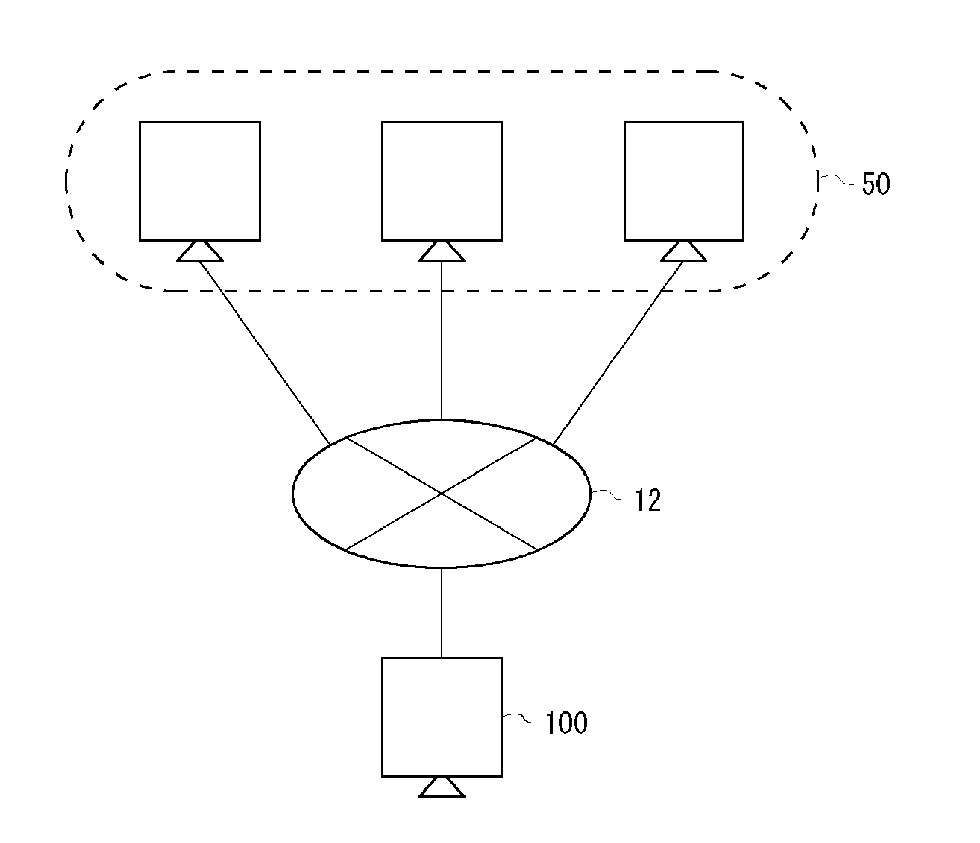
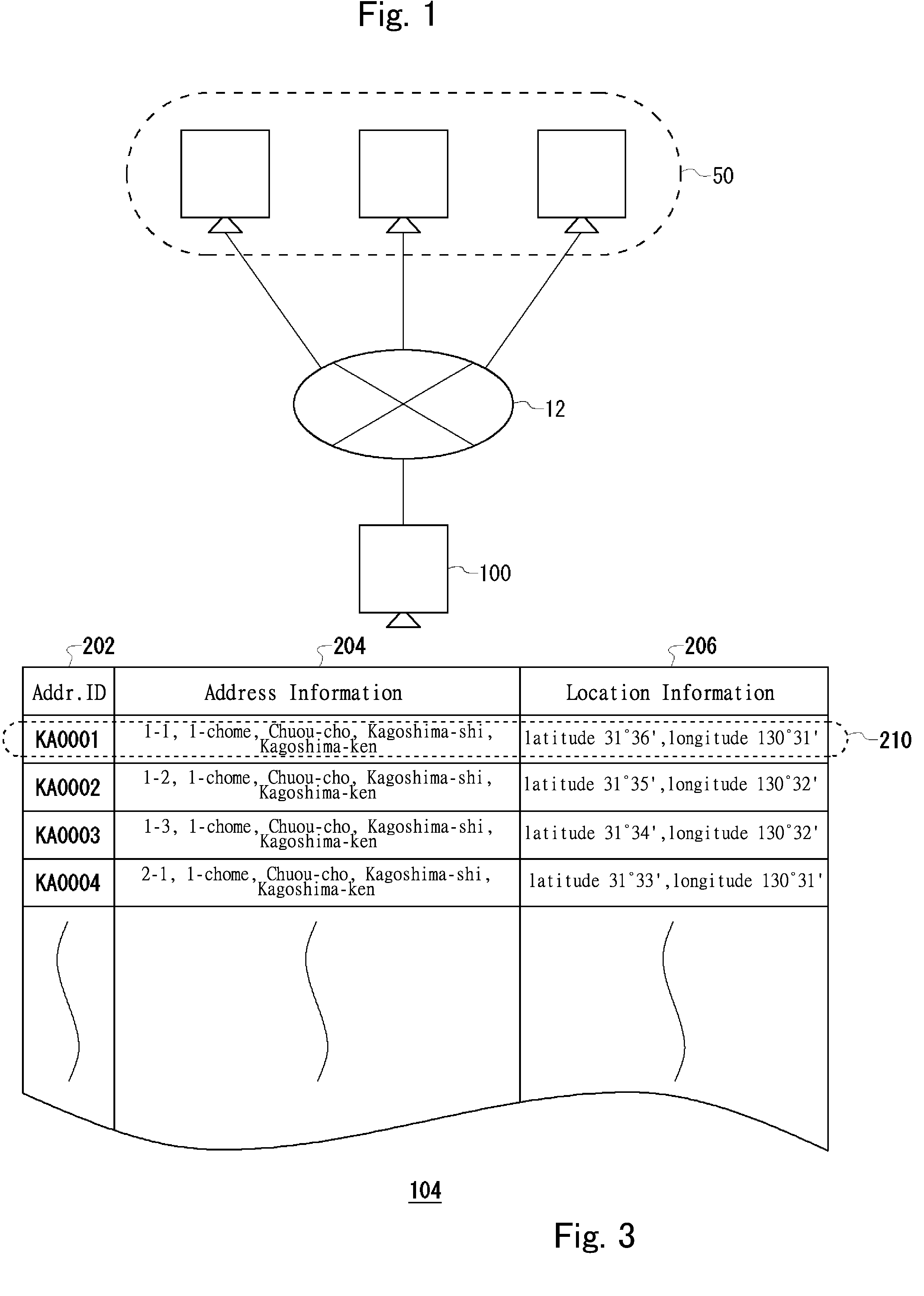
[0052]FIG. 1 is a schematic diagram for showing the configuration of a three-dimensional map image generation system in accordance with the embodiment 1. The three-dimensional map image generation system 10 of the embodiment 1 serves to generate a three-dimensional map image including stereoscopic images such as columnar images representing office buildings, dome buildings, spherical constructions and so forth by making use of the information contained in Web pages, messages and comments written in electronic bulletin boards, weblogs, email and any other types of information which can be obtained through the Internet. For the sake of clarity in explanation, a Web page, as the term is used herein, is to be broadly interpreted to include any types of these information sources. Also, the term “columnar image” is used herein to represent polygonal columns such as a square column, cylindrical columns and any other columnar shapes. Incidentally, there are a variety of types of content whi...

embodiment 2

[0113]In accordance with the embodiment 1, a columnar image is arranged in the location on the map image which is specified by the location information in association with the address information of the building. However, in accordance with the embodiment 2, a columnar image is arranged in the location below the ground on the map image which is specified by the location information in association with the address information of the building.

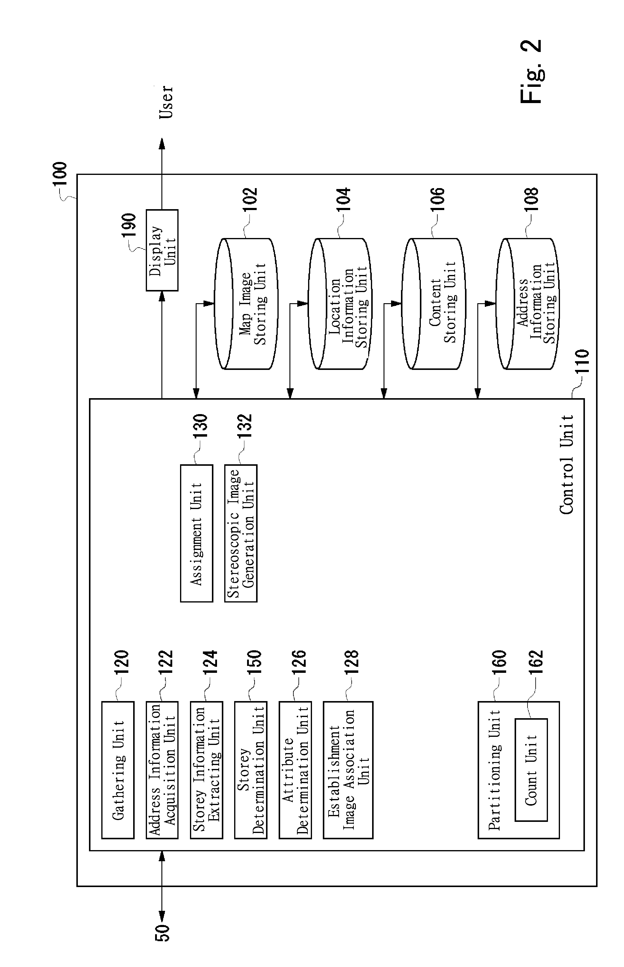
[0114]FIG. 9 is a schematic diagram for showing the configuration of the three-dimensional map image generation apparatus 100 in accordance with the embodiment 2. In FIG. 9, like reference numbers indicate the same elements as illustrated in FIG. 2, and detailed explanation is omitted. While the configuration of the three-dimensional map image generation apparatus 100 in accordance with the embodiment 2 has the similar configuration of the three-dimensional map image generation apparatus 100 as illustrated in FIG. 2, the storey determination unit...

embodiment 3

[0119]In accordance with the embodiment 1, the same establishment image is attached to the respective blocks irrespective of the establishment. However, in accordance with the embodiment 3, different images are attached to the blocks in accordance with the attribute of the establishment.

[0120]While the configuration of the three-dimensional map image generation apparatus 100 in accordance with the embodiment 3 has the similar configuration of the three-dimensional map image generation apparatus 100 as illustrated in FIG. 2, the establishment image association unit 128 of the embodiment 3 is provided further with the additional function as follows. Incidentally, in the following description, like reference numbers indicate the same elements as illustrated in FIG. 2, and detailed explanation is omitted.

[0121]The establishment image association unit 128 is provided further with the functionality of associating an establishment with a different establishment image in accordance with the...


PUM


Abstract

A method and server computer for generating map images and providing the map images to users through the Internet are described. Web sites are automatically and recursively visited and downloaded through hyperlinks. Content items containing address and establishment information are retrieved from the information as downloaded from the visited web sites. The content retrieved items are indexed to associate the address information items contained therein with the establishment information items contained therein about establishments which are located in the addresses associated therewith respectively. A visual indication indicative of the establishment corresponding to an establishment information item is superimposed on a map image in a position corresponding to the address of this establishment with reference to the indexed content items. The map image is transmitted to a user through the Internet in response to a request message from the user.

Description

BACKGROUND OF THE INVENTION[0001]1. Field of the Invention[0002]The present invention relates generally to a method and server computer for generating map images and providing the map images to users through the Internet, and more particular to a technique of generating a virtual space in which stereoscopic images are placed to represent real buildings and the like which exist in the real world.[0003]2. Description of the Related Art[0004]In recent years, three-dimensional map images become available in a map space provided by a car navigation system or in a virtual space provided for realizing a virtual shopping mall. These three-dimensional map images are, for example, columnar images such as rectangular parallelepiped images and so forth which represent real world buildings. The three-dimensional map image can be created, for example, by searching a database for height data of a building in correspondence with the X and Y coordinates of a map element, and arranging a three-dimens...

Claims


Application Information

Patent Timeline
IPC IPC(8): G06T15/00G09G5/00
CPCG06T17/05G06F17/30905G06F16/9577
Inventor UETABIRA, SHIGEKI
Owner INTERMAN CORP
Learn More