Safest transportation routing

a transportation route and routing technology, applied in surveying and navigation, navigation instruments, instruments, etc., can solve the problems of not providing a determination of the safest transportation route, the minimum amount of risk, and the current navigation system

Inactive Publication Date: 2010-02-11
RM ACQUISITION
View PDF20 Cites 136 Cited by
  • Summary
  • Abstract
  • Description
  • Claims
  • Application Information

AI Technical Summary

Benefits of technology

[0007]The present disclosure describes methods and systems which determine a safest transportation route between an origin and a destination. In particular, a method or a system for determining a safest route may include obtaining indications of the origin and the destination, accessing map data to determine candidate routes, determining a risk value for each candidate route, and comparing the risk values of the candidate routes to determine the safest route. The risk values for each candidate route may correspond to a level of safety for each candidate route.

Problems solved by technology

Current navigation systems, digital map data, routing systems and commercial roadway databases, however, do not provide a determination of a safest transportation route, that is, a route that has a minimum amount of risk.
Current navigation systems, routing systems and commercial roadway databases also do not provide a way for a user to select a safest route that is tailored to the user's personal safety preferences.

Method used


Image

  • Safest transportation routing
  • Safest transportation routing
  • Safest transportation routing

Examples


Embodiment Construction

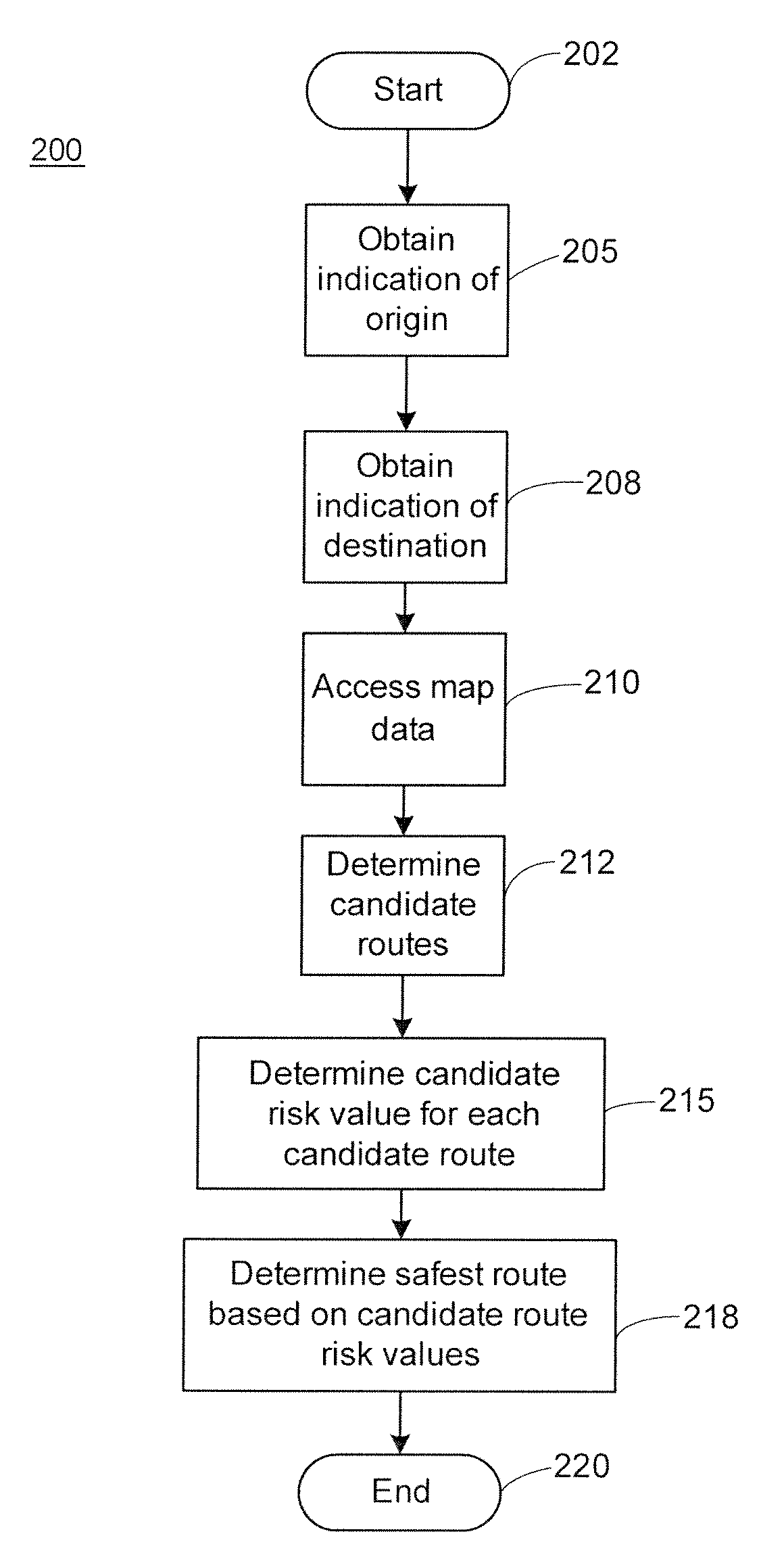
[0025]Generally speaking, the methods and systems described herein determine a set of candidate routes between the origin and the destination, determine a risk value for each candidate route, and compare the risk values to find a “safest route” or path to be used in traveling from the origin to the destination. The risk value for each candidate route may be determined using or based on one or more different safety factors or safety criteria, such as physical route attributes, statistical data associated with the candidate route, personal safety preferences and / or personal convenience preferences. Some of the safety criteria may be obtained from one or more databases, such as from a database including map data or a database including statistical data. In addition, some of the safety factors or criteria relating to personal preferences may be obtained from user input and the user may prioritize the one or more different safety criteria to tailor the determination of the safest route t...


PUM


Abstract

Methods and systems for determining a safest transportation route include determining a risk value for each of a set of candidate routes between an origin and a destination based on one or more safety factors or criteria, and comparing the risk values to determine the safest route. The risk values may be based upon default or selected safety factors, and may correspond to a normalized cost per unit distance. Safety factors may be derived from map data, obtained from user input and/or derived from other statistical data. User preferences and priorities may be included in the process for determining a safest route. Determined safest routes may be displayed, and may indicate especially risky portions of the determined safest route.

Description

RELATED APPLICATION[0001]This application is a regularly filed application claiming priority to co-pending U.S. Provisional Application Ser. No. 61 / 087,846, entitled “Safest Transportation Routing” filed Aug. 11, 2008, the entire disclosure of which is hereby expressly incorporated by reference herein.FIELD OF THE DISCLOSURE[0002]The present disclosure generally relates to navigation and routing systems, and more specifically, to methods and systems of determining a safest transportation route.BACKGROUND[0003]Determining a transportation route using navigation or route evaluation systems has been commonplace for many years. Generally speaking, navigation or route evaluation systems may determine a route, e.g., a geographical route, over which a person or other transported entity may traverse, typically (but not necessarily) while driving or being transported in a motor vehicle. Websites, in-dash navigation systems, wireless phones and devices, portable navigation devices (PNDs) and ...

Claims


Application Information

Patent Timeline
Patent Type & Authority Applications(United States)
IPC IPC(8): G01C21/00
CPCG01C21/3461
Inventor FROEBERG, PETERLEVIN, KENNETH H.
Owner RM ACQUISITION
Why Eureka
Try Eureka