Apparatus for measurement of vertical obstructions

a technology of vertical obstruction and apparatus, applied in the field of aerial instruments for measuring vertical obstructions, can solve the problems of difficult detection of fine structures such as antennae atop towers or buildings, poor resolution, and small errors in the apparent position of vertical objects

Active Publication Date: 2010-04-22
RAPID IMAGING TECH LLC
View PDF7 Cites 19 Cited by
  • Summary
  • Abstract
  • Description
  • Claims
  • Application Information

AI Technical Summary

Problems solved by technology

The resolution suffers because aerial photographs are taken in a direction which is orthogonal to the measurement of interest.
This means that small errors in the apparent position of vertical objects are magnified geometrically.
Also, fine structures such as antennae atop towers or buildings are difficult to detect, yet an aircraft striking one of these small antennae could be damaged or destroyed.
However, the detection of smaller features is a problem.
LiDAR systems may be capable of measuring objects as small as a meter across, but cannot hope to measure an antenna of ½ inch diameter.
However, in practice it is not practical to image a building with enough pixel resolution to capture from the base of the building and be able to clearly measure the lightening rod on its top.
The existing methods do not provide for consistent and accurate measurement of the fine structure of obstructions.

Method used


Image

  • Apparatus for measurement of vertical obstructions
  • Apparatus for measurement of vertical obstructions
  • Apparatus for measurement of vertical obstructions

Examples


Embodiment Construction

[0016]The particular values and configurations discussed in these non-limiting examples can be varied and are cited merely to illustrate embodiments and are not intended to limit the scope of the invention.

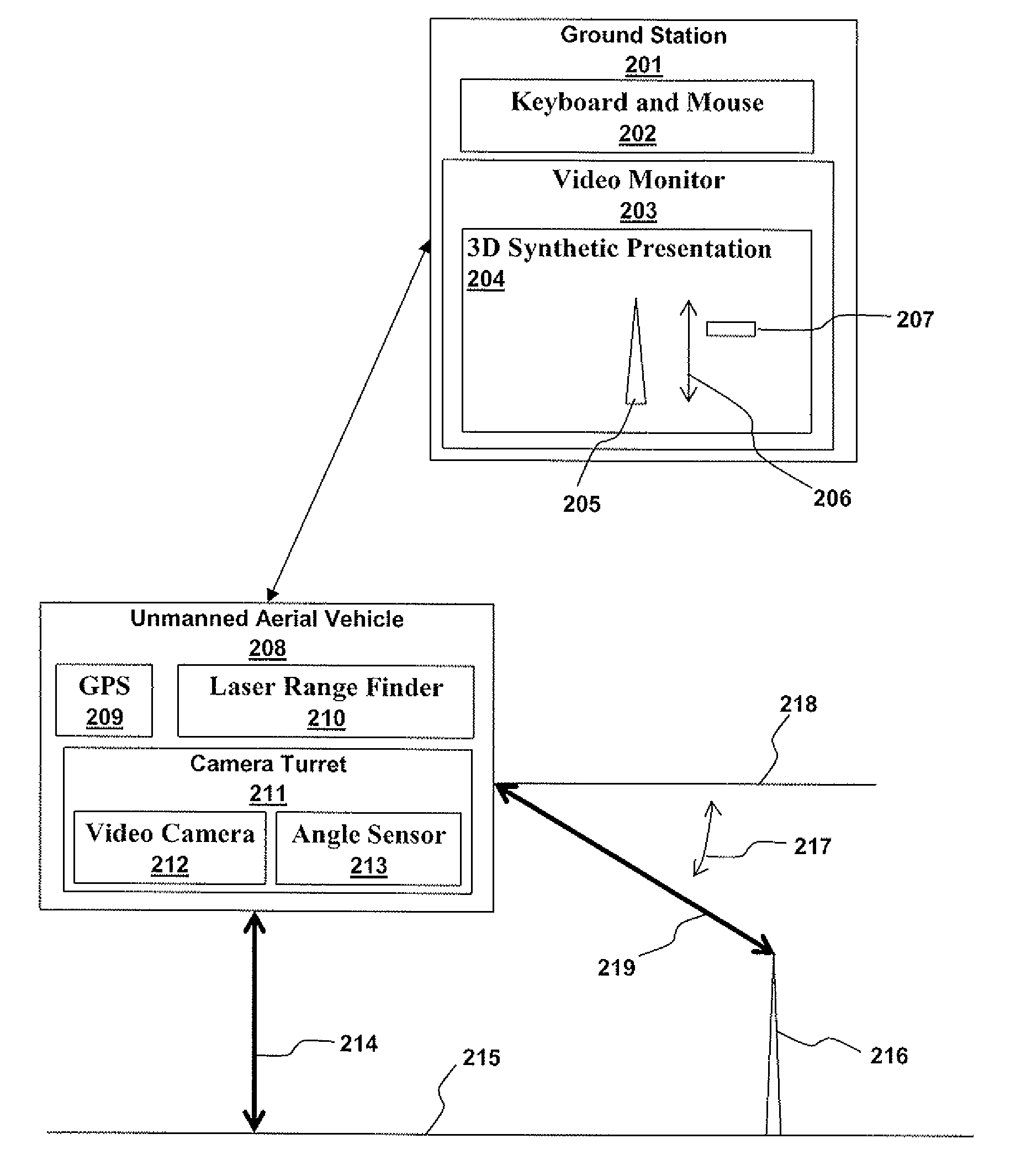
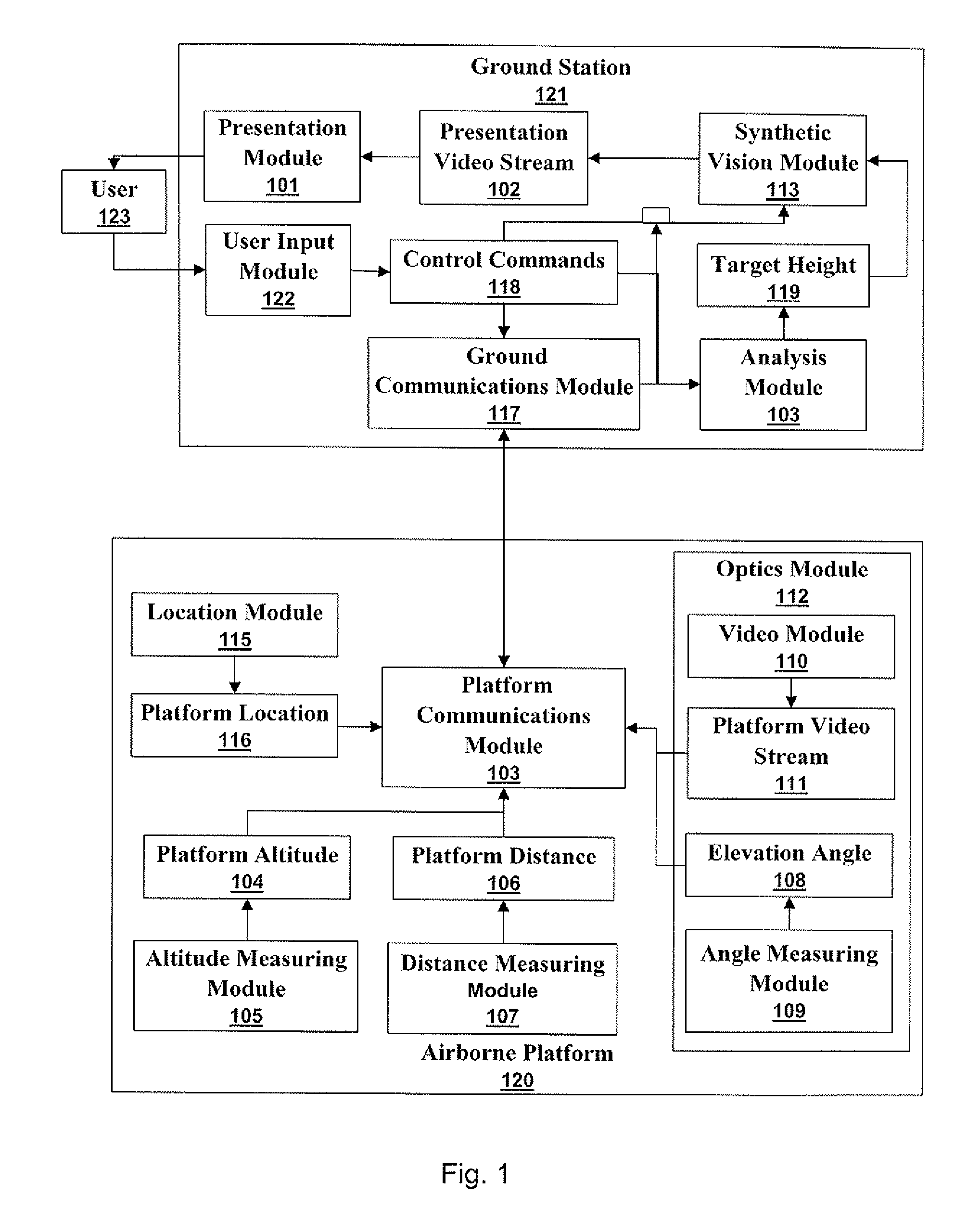
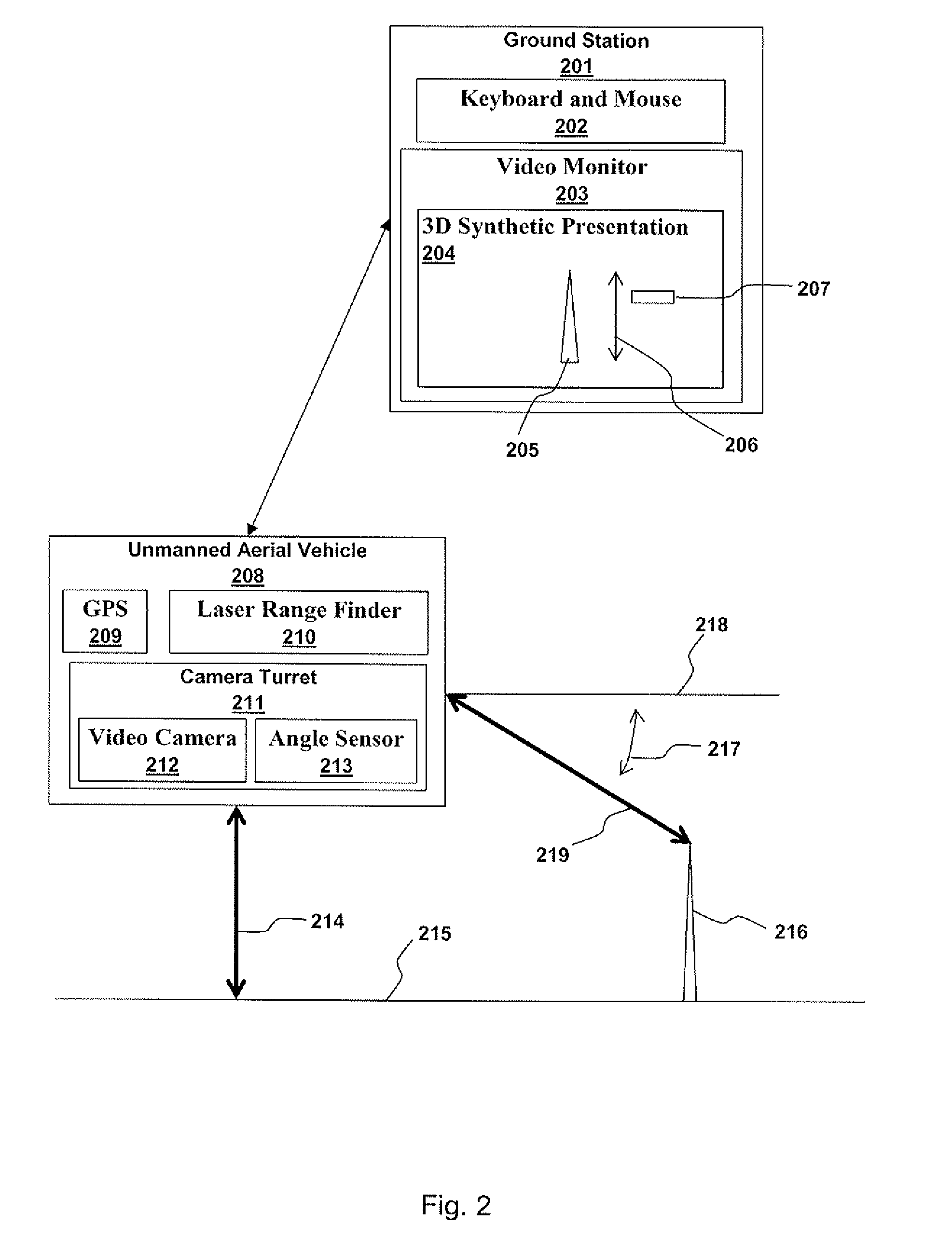
[0017]Accurate measurements of flight path obstructions are taken from a moving aerial platform. Platform position, including altitude, is combined with dynamic data including target distance and target elevation data to calculate obstruction height or altitude. An optical subsystem on the aerial platform images the obstructions and provides a video stream showing the obstructions. The video stream and aerial platform data are wirelessly communicated to a control terminal where an operator observes a presentation of obstructions and obstruction altitudes or heights. The operator can issue commands to the aerial platform.

[0018]FIG. 1 illustrates a ground station 121 in communication with an airborne platform 120 in accordance with aspects of the embodiments. A user 123 supplies con...


PUM


Abstract

Accurate measurements of flight path obstructions are taken from a moving aerial platform. Platform position, including altitude, is combined with dynamic data including target distance and target elevation data to calculate obstruction height or altitude. An optical subsystem on the aerial platform images the obstructions and provides a video stream showing the obstructions. The video stream and aerial platform data are wirelessly communicated to a control terminal where an operator observes a presentation of obstructions and obstruction altitudes or heights. The operator can issue commands to the aerial platform.

Description

TECHNICAL FIELD[0001]Embodiments relate to the fields of aviation, mapping, and geospatial data. In particular, embodiments relate to the creation and verification of data relating to flight path obstructions.BACKGROUND[0002]One obvious requirement for aircraft safety is to avoid flying into things. There are many possible flight path obstructions most of them having a specific and constant geographic coordinate and height. Obstruction coordinate and height data are contained in databases such as the various geographic information system (GIS) databases used in flight planning and in producing navigation maps for pilots. New obstructions are constantly being produced during and after construction activities and the quicker the new obstructions are added to the databases, the safer air travel is. Furthermore, obstruction location and height should be occasionally verified to correct faulty GIS data.[0003]Object height has been measured in a number of different ways. For example, aeri...

Claims


Application Information

Patent Timeline
Patent Type & Authority Applications(United States)
IPC IPC(8): H04N7/18G01C3/08G06K9/00
CPCG01C11/00G01S7/003G01C21/16
Inventor ABERNATHY, MICHAEL FRANKLIN
Owner RAPID IMAGING TECH LLC
Why Eureka
Try Eureka