Three-dimensional geographical scene simulation method for virtual emergency exercises

An emergency drill and scene simulation technology, applied in the field of 3D geographic scene simulation, can solve problems such as cumbersome operations, 3D scenes without geographical significance, seam errors, etc., and achieve the effect of ensuring accuracy

Active Publication Date: 2015-01-28
FUJIAN NORMAL UNIV
View PDF2 Cites 32 Cited by
  • Summary
  • Abstract
  • Description
  • Claims
  • Application Information

AI Technical Summary

Problems solved by technology

[0008] ①The operation is cumbersome;
[0009] ② It is necessary to adjust the geographic location of each block in the engine so that each block can be seamlessly connected, and this method will cause seam errors between blocks;
[0010] ③The generated 3D scene has no real geographical meaning and no original coordinates
[0013] ②Using the gray value to represent the elevation value, divide the elevation of the area into 256 levels, 0 means the lowest, and 255 means the highest. For such elevation data, the error of the three-dimensional terrain will increase with the increase of the relative height difference. 1000 meters The height difference can reach nearly 4 meters, which cannot meet the needs of actual drills (such as emergency evacuation);
[0014] ③The generated 3D scene does not have real geographical meaning
[0015] In view of the shortcomings in the above two methods, the purpose of the present invention is to solve the problems in the above two methods that the production steps are cumbersome, the data sources are limited, and the three-dimensional geographical scene with real geographical significance cannot be constructed in a real sense.

Method used


Image

  • Three-dimensional geographical scene simulation method for virtual emergency exercises
  • Three-dimensional geographical scene simulation method for virtual emergency exercises
  • Three-dimensional geographical scene simulation method for virtual emergency exercises

Examples


Embodiment Construction

[0062] The technical solution of the present invention will be specifically described below in conjunction with the accompanying drawings.

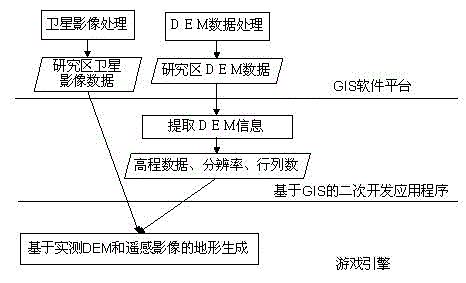
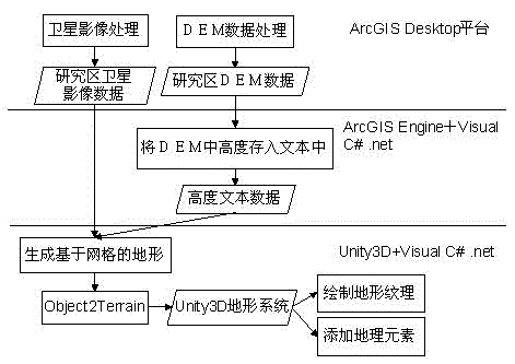
[0063] Such as figure 1 As shown, a 3D geographic scene simulation method for virtual emergency drills includes the following steps,

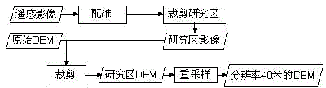
[0064] Step S1: Obtain the remote sensing image of the area to be simulated and the elevation data in the DEM through GIS software, and conduct field surveys on the area to be simulated or find a larger-scale topographic map and a higher-precision geometrically corrected remote sensing image to Obtain the coordinates of feature control points for registration of remote sensing images;

[0065] Step S2: Preprocess the remote sensing images in step S1 and the elevation data in the DEM: first register and then crop the remote sensing images, and first crop and then resample the elevation data in the DEM to obtain consistent spatial reference, size matching, Remote sensing images and DEM with the same spatia...


PUM


Abstract

The invention relates to a three-dimensional geographical scene simulation method for virtual emergency exercises. The method comprises the steps of: obtaining elevation data in DEM by using GIS software, and interpreting earth surface appendage information by using a registered high-resolution remote sensing image, or obtaining surface features and land utilization information by using an existing measured drawing; then, establishing topography and landforms by using the information with true geographic meanings in a game engine, wherein a key technical process is the conversion between a rectangular coordinate system in the game engine and a geographic coordinate system in the GIS software; at last, combining and reconstructing a three-dimensional terrain and geographic element model with true geographic meanings on a game engine platform, and achieving establishment of a realistic three-dimensional scene. The three-dimensional geographical scene simulation method virtual emergency exercises is convenient to operate and unnecessary to limit shape and size of the area, ensures elevation accuracy of DEM, and can automatically generate the three-dimensional science with the true geographic meanings.

Description

technical field [0001] The invention relates to a three-dimensional geographic scene simulation method for virtual emergency drills. Background technique [0002] Since its birth in the 1980s, serious games have been widely used in various fields such as military affairs, medicine, education, and scientific research. A serious game is a game that is not intended to be entertaining. The key difference between a serious game and a recreational game is whether the game is realistic and scientific. Serious games can be used to simulate some accidents and disasters that may occur in reality, such as earthquakes, fires, subway anti-terrorism, etc., and users can enter these game scenes in the form of any role to experience the process of accidents personally. In order to achieve the purpose of education and training for users. Therefore, serious games have been widely used in emergencies and emergency deduction, and are currently a research hotspot in this field, and will also ...

Claims


Application Information

Patent Timeline
Patent Type & Authority Applications(China)
IPC IPC(8): G06T17/05
CPCG06T17/05
Inventor 林广发刘鑫垚张明锋李清远杨城
Owner FUJIAN NORMAL UNIV
Why Eureka
Try Eureka