GPS baseband controller architecture

a controller and baseband technology, applied in the direction of satellite radio beaconing, measurement devices, instruments, etc., can solve the problems of battery imposing a limit to the compactness of the gps device, hardware components needing a continuous power supply, and preserving power, so as to achieve high position accuracy and low position accuracy , the effect of preserving power

Active Publication Date: 2011-05-05
MAXLINEAR INC
View PDF23 Cites 35 Cited by
  • Summary
  • Abstract
  • Description
  • Claims
  • Application Information

AI Technical Summary

Problems solved by technology

The difficulty in preserving power is that hardware components require a continual power supply in order to track and process signals received from the satellites to generate navigation updates at a required rate.
For handheld GPS devices, the size and the associate weight of the battery impose a limit to the compactness of the GPS devices.

Method used


Image

  • GPS baseband controller architecture
  • GPS baseband controller architecture
  • GPS baseband controller architecture

Examples


Embodiment Construction

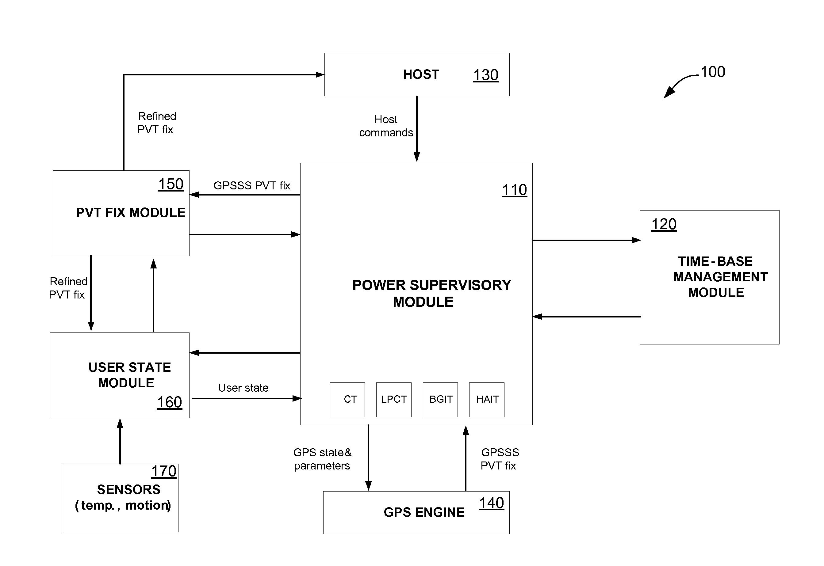
[0021]FIG. 1 is a simplified block diagram of a GPS receiver 100 according to an embodiment of the present invention. GPS receiver 100 includes a plurality of functional modules. In an embodiment, the GPS receiver may include a radio frequency (RF) front end module (not shown) that acquires and tracks a RF signal from a minimum number of satellites and down-converts the RF signal to an IF signal. An analog-to-digital-converter module (not shown) digitizes the IF signal and provides the digital IF signal to an GPS engine 140. GPS engine 140 produces a Position, Velocity, Time (PVT) fix and provides the PVT fix to a power supervisor module 110. Power supervisor module 110 passes the PVT fix to a PVT fix module 150 that processes the PVT fix to potentially enhance its quality (e.g., by means of sensor-assisted or non-sensor-assisted position filtering, etc), stores the processed PVT fix, and assigns a position accuracy index to it. In an embodiment, the position accuracy index may assi...


PUM


Abstract

A GPS receiver includes an RF front end for acquiring and tracking a satellite signal and a baseband processor configured to preserve power. The baseband processor includes a GPS engine configured to process the satellite signal and generate a PVT fix, a power supervisory module for receiving the PVT fix, and a user state module that determines an environmental state, wherein the power supervisory module may power down the GPS receiver for a period of time based on a result of the determined environment state. The baseband processor also includes a time-based management module that adjusts the TCXO in response to the determined environmental state. The GPS receiver includes a plurality of operation modes, each of which is associated with a plurality of tracking profiles.

Description

CROSS-REFERENCES TO RELATED APPLICATIONS[0001]The present application claims benefit under 35 USC 119(e) of U.S. provisional application No. 61 / 258,171, filed Nov. 4, 2009, entitled “MSC System Architecture,” the content of which is incorporated herein by reference in its entirety.BACKGROUND OF THE INVENTION[0002]The present invention relates to power control devices and methods, and more particularly, to system architectures and algorithms utilized in GPS receivers.[0003]The Global Positioning System (GPS) is a satellite-based navigation system that requires low power in order to preserve battery life in handheld applications. There are currently three GPS systems: the NAVSTAR Global Positioning System controlled by the United States Defense Department; the GLONASS maintained by the Russian Republic; and the GALILEO system proposed in Europe.[0004]To decode satellite signals, a GPS receiver must first acquire the signals transmitted by a minimum number of satellites. The GPS receiv...

Claims


Application Information

Patent Timeline
Patent Type & Authority Applications(United States)
IPC IPC(8): G01S19/48G01S19/42G01S19/34
CPCG01S19/34
Inventor SPYROPOULOS, IOANNISANANDAKUMAR, ANANDLECLERCQ, MAXIMERASSE, YVES
Owner MAXLINEAR INC
Why Eureka
Try Eureka