System and method for computing and scoring the complexity of a vehicle trip using geo-spatial information

a vehicle trip and complexity technology, applied in the field of system and method for computing and scoring the complexity of a vehicle trip using geospatial information, can solve the problems of inherently more risky, more complex or intricate routes are subject to a larger proportion of directional changes

Active Publication Date: 2013-02-21
HARTFORD FIRE INSURANCE
View PDF18 Cites 151 Cited by
  • Summary
  • Abstract
  • Description
  • Claims
  • Application Information

AI Technical Summary

Benefits of technology

[0003]Therefore, there is a need in the art for an accurate and objective measure of route complexity that is correlated with the likelihood of accidents and losses. Such a measure can be calculated from high frequency location information and/or other vehicle data, such as speed, orientation, and acceleration. Statistical analysis of the high fr

Problems solved by technology

More complex or intricate routes are subject to a larger proportion of directional changes, accelerations, decelerations

Method used


Image

  • System and method for computing and scoring the complexity of a vehicle trip using geo-spatial information
  • System and method for computing and scoring the complexity of a vehicle trip using geo-spatial information
  • System and method for computing and scoring the complexity of a vehicle trip using geo-spatial information

Examples


Embodiment Construction

[0022]To provide an overall understanding of the invention, certain illustrative embodiments will now be described, including systems and methods for computing and scoring the complexity of a vehicle trip using geo-spatial information. However, it will be understood by one of ordinary skill in the art that the systems and methods described herein may be adapted and modified as is appropriate for the application being addressed and that the systems and methods described herein may be employed in other suitable applications, and that such other additions and modifications will not depart from the scope thereof.

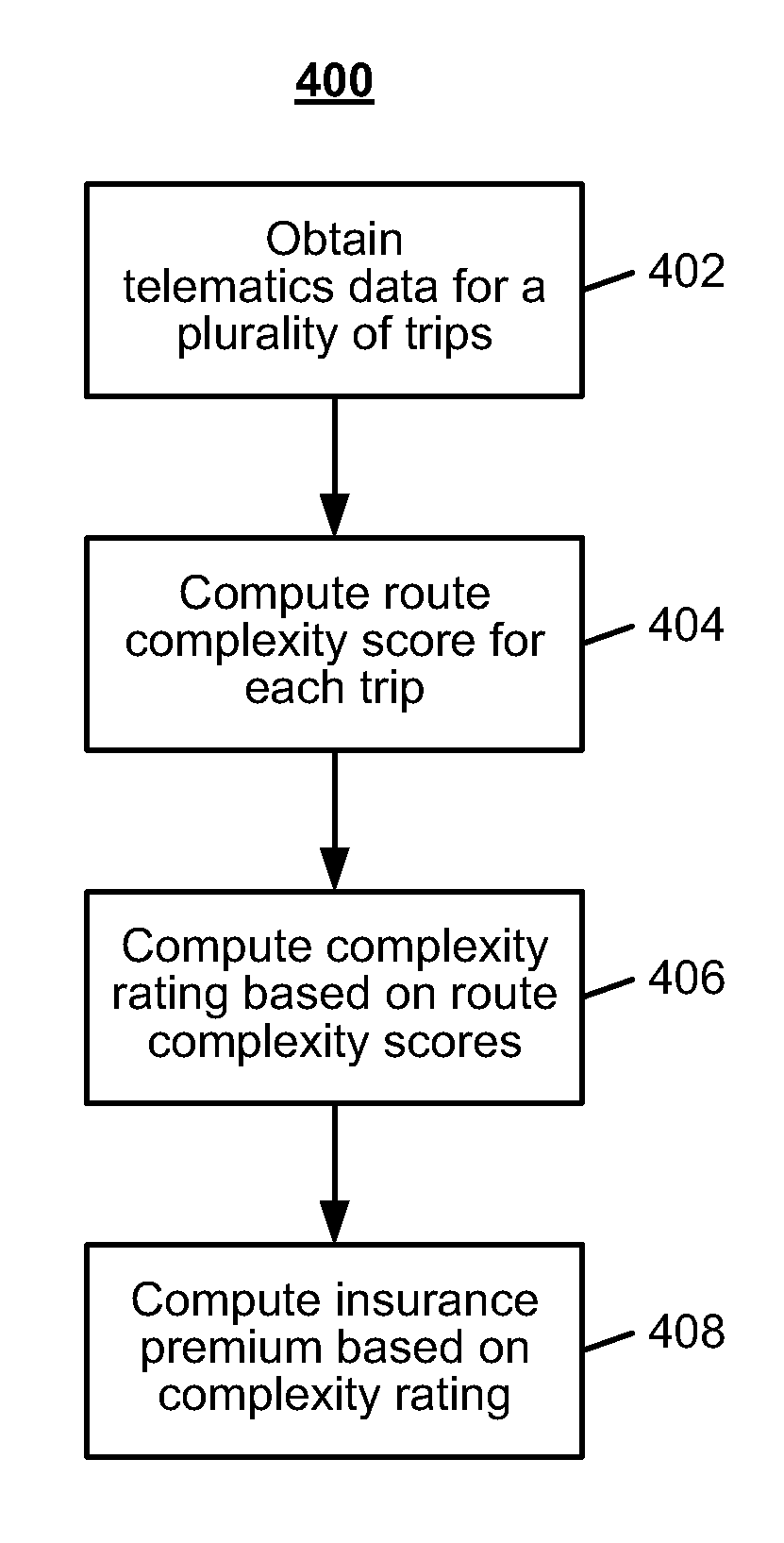
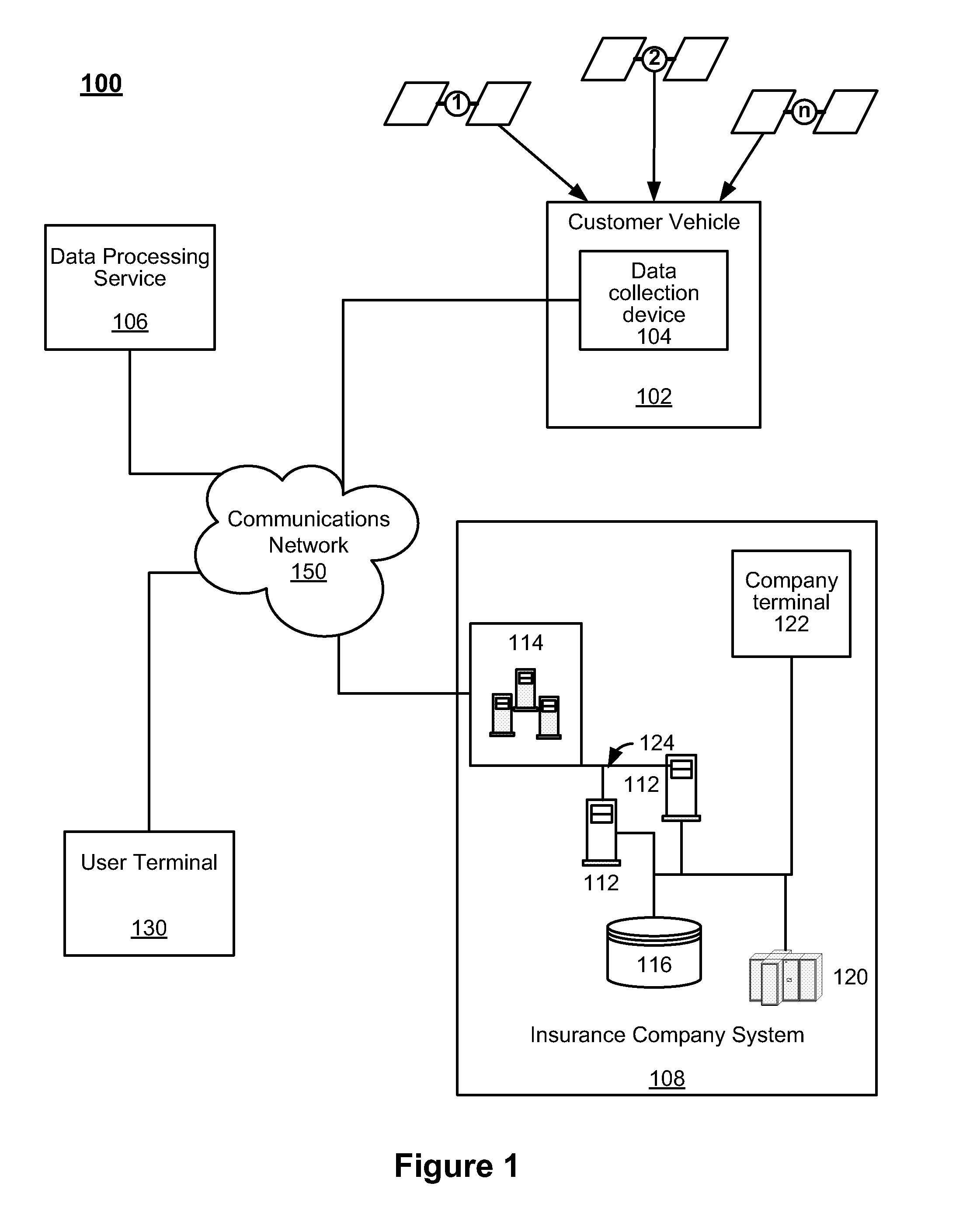
[0023]FIG. 1 is a block diagram of a system 100 for setting the price of an insurance premium based on route complexity, according to an illustrative embodiment. The system 100 uses data collected along one or more routes traveled by a vehicle to determine the complexity of those routes. In general, the more turns, changes in orientation, accelerations, decelerations, changes in...


PUM


Abstract

Systems and methods are disclosed herein for pricing an insurance premium based on route complexity. The system includes a computer memory and a processor in communication with the computer memory. The computer memory stores telematics data received from a sensor within a vehicle. The telematics data includes at least one of geo-position information of the vehicle and vehicle kinematics data. The processor is configured to compute a complexity score of the trip based on the telematics data. The processor is also configured to determine a price for automobile insurance for the driver based on the complexity score of the at least one trip.

Description

FIELD OF THE INVENTION[0001]In general, the invention relates to a computerized system and method for determining the price of an insurance premium based on the complexity of one or more vehicle trips.BACKGROUND OF THE INVENTION[0002]The insurance industry has begun exploring the use of telematics sensors and other location-aware devices in motor vehicles as a way of determining driver behavior and, from this, driver risk for the purposes of underwriting, pricing, renewing, and servicing vehicle insurance. The devices can capture very high frequency information on location, speed, vehicle handling, vehicle characteristics, and other factors, which can be used in setting vehicle insurance rates. This rich high frequency data can be used to understand the intricacy or complexity of the specific path a vehicle takes from one destination to another. More complex or intricate routes are subject to a larger proportion of directional changes, accelerations, decelerations, braking, and othe...

Claims


Application Information

Patent Timeline
IPC IPC(8): G06Q40/00
CPCG06Q40/08G06Q10/10
Inventor COLEMAN, MARK S.BARBATO, DARREL S.HUANG, LIHU
Owner HARTFORD FIRE INSURANCE
Why Eureka
Try Eureka