Fast and accurate geomapping

a geomapping and accurate technology, applied in the field of mapping, can solve problems such as significant slowing down queries

Active Publication Date: 2016-06-16
IBM CORP
View PDF2 Cites 13 Cited by
  • Summary
  • Abstract
  • Description
  • Claims
  • Application Information

AI Technical Summary

Problems solved by technology

However, the drawback is the required additional operations that account for the Earth's shape, which significantly slow down queries.
However, the results can be inaccurate due to the one-sided “closeness” property of geohashes.

Method used


Image

  • Fast and accurate geomapping
  • Fast and accurate geomapping
  • Fast and accurate geomapping

Examples


Embodiment Construction

[0016]The present principles are directed to fast and accurate geomapping.

[0017]The present principles are directed to performing geomapping using geohashes that remove the perceived limitation regarding geohashes being of limited use for proximity searches. Geomapping in accordance with the present principles advantageously provides accurate results (no false positives / negatives) and works at an extremely high throughput.

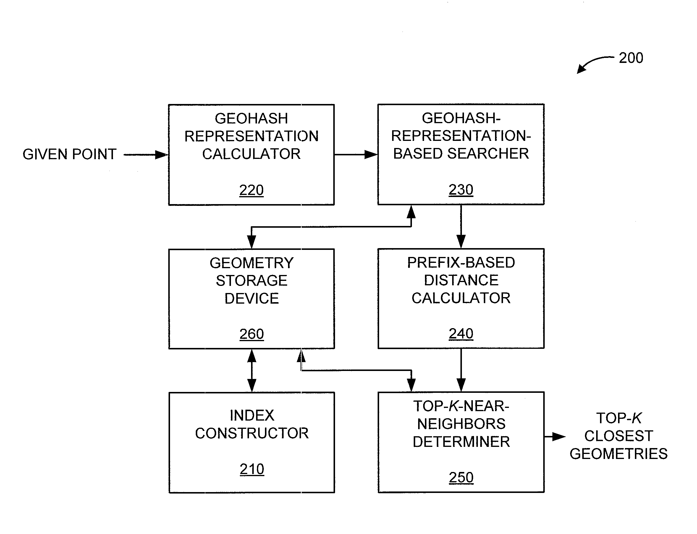
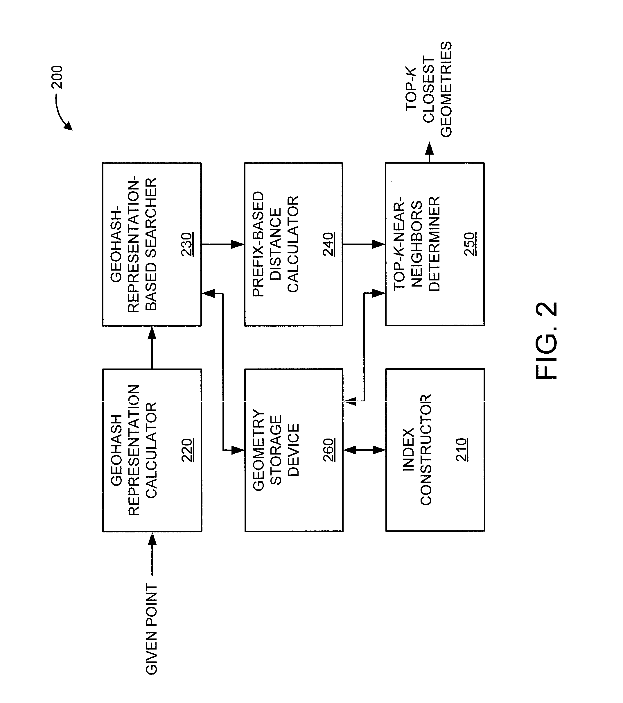
[0018]In an embodiment, the present principles exploit and / or otherwise use the following two ideas: (a) the calculation of “geohash covers”, which is a new concept to ensure accurate results; (b) the use of a patricia trie to minimize the number of calculations while searching the index to provide high throughput.

[0019]In an embodiment, the present principles advantageously prune the space of possible objects of interest using the adaptive resolution property of geohash encoding combined with fast common-prefix string lookup techniques. The adaptive resolution pro...


PUM


Abstract

A system and method are provided for discovering k-nearest-neighbors to a given point within a certain distance d. The method includes constructing an index of geometries using geohashes of geometries as an indexing key to obtain an indexed set of geometries, and calculating a geohash representation of the given point with a resolution equal to a magnitude value of d. The method includes searching for a closest-prefix geometry from the indexed set using the geohash representation of the given point, and identifying geometries from the indexed set having a same prefix as the closest-prefix geometry. The method further includes calculating distances between the given point and the geometries identified from the indexed set having the same prefix as the closest-prefix geometry, and determining k geometries with respective shortest distances less than d from the geometries identified from the indexed set having the same prefix as the closest-prefix geometry.

Description

GOVERNMENT RIGHTS[0001]This invention was made with Government support under Contract No.: W911NF-09-2-0053 awarded by the Army Research Office (ARO). The Government has certain rights in this invention.BACKGROUND[0002]1. Technical Field[0003]The present invention relates generally to mapping and, in particular, to fast and accurate geomapping.[0004]2. Description of the Related Art[0005]Geomapping is finding the “K-closest” objects that lie in the area within a certain distance (radius) from a given location and is used in a number of located-based applications. Geomapping has been used for the identification of points of interests in a map (e.g., find the 20 closest restaurants, ATMs, theatres, and so forth within a 1-mile radius from the location of a user), proximity-based queries (e.g., find the 10 closest taxis with respect to a user's location), and demographics-based queries & foot-traffic discovery (e.g., find 100 mobile users that are located the closest within 0.3 miles f...

Claims


Application Information

Patent Timeline
Patent Type & Authority Applications(United States)
IPC IPC(8): G06F17/30
CPCG06F17/30321G06F17/30241G06F17/30985G06F16/9014G06F16/90344G06F16/29
Inventor AGRAWAL, DAKSHIGANTI, RAGHU K.SRIVATSA, MUDHAKARZERFOS, PETROS
Owner IBM CORP
Why Eureka
Try Eureka