
Portable mobile transceiver for GPS navigation and vehicle data input for dead reckoning mode

a mobile transceiver and dead reckoning technology, applied in surveying, navigation, instruments, etc., can solve the problems of obstructing gps signal reception, mobile devices cannot always obtain positional fixes, and gps signals are not always reliably received

Inactive Publication Date: 2016-09-01
MALIKIE INNOVATIONS LTD
View PDF0 Cites 1 Cited by
  • Summary
  • Abstract
  • Description
  • Claims
  • Application Information

AI Technical Summary

Benefits of technology

Enables continuous position determination and navigation assistance even in areas with poor GPS signal coverage, providing accurate and reliable location updates through a combination of GPS and dead reckoning data.

Problems solved by technology

GPS signals are not always reliably received by a mobile device, such that a mobile device cannot always obtain a positional fix when desired, such as when using a navigation application on the mobile device while driving an automobile.
In particular, it is known that tall objects, such as buildings and trees obstruct GPS signal reception.

Method used


Image

  • Portable mobile transceiver for GPS navigation and vehicle data input for dead reckoning mode
  • Portable mobile transceiver for GPS navigation and vehicle data input for dead reckoning mode
  • Portable mobile transceiver for GPS navigation and vehicle data input for dead reckoning mode

Examples


Embodiment Construction

[0012]The following description provides examples and other disclosure, which teach those of ordinary skill in the art how to practice implementations and embodiments of inventive aspects described herein. As such, the description is not limiting, but rather is exemplary.

[0013]For convenience, in this description, the term “mobile transceiver device” (shorted in “device”) is generally used to refer to any portable or mobile network-enabled device that has capabilities to send and receive data, such as data generated by web browsing, e-mail, SMS, instant messaging, and the like. As will become clear, a variety of devices in a variety of form factors can meet such a definition, including, for example, smartphones, laptops configured with appropriate network connections and user input devices, tablet computers, and netbooks.

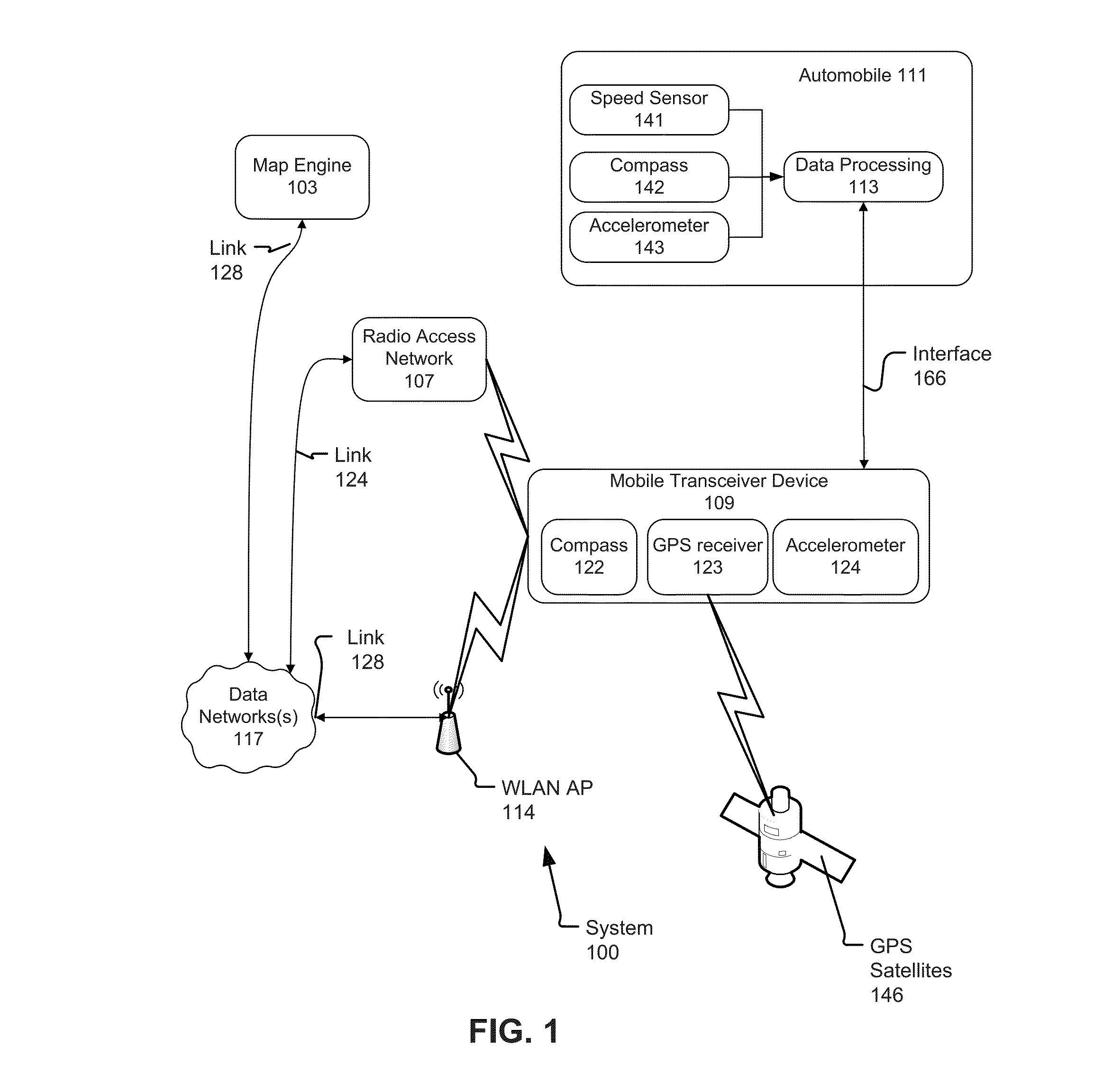
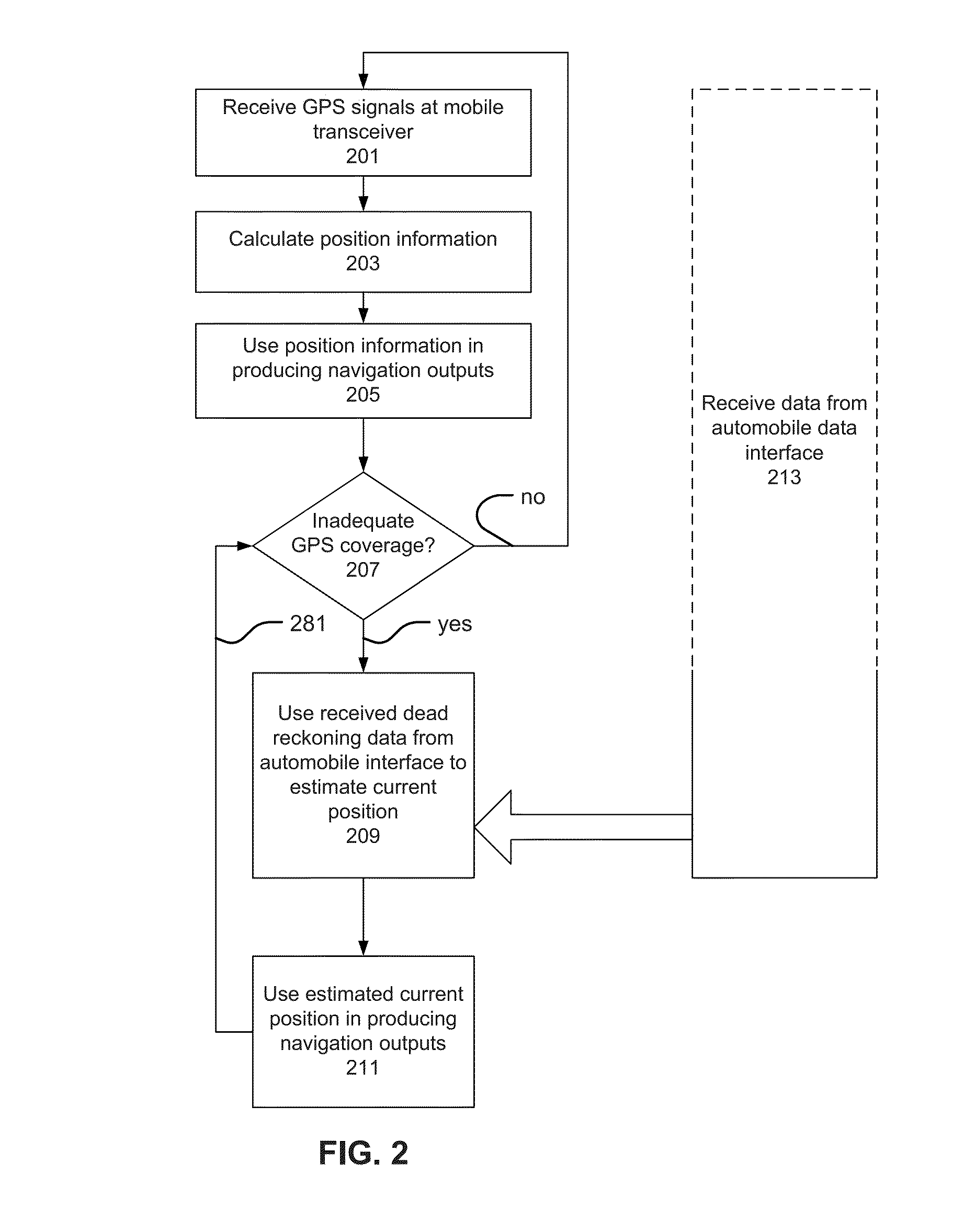
[0014]Determining a physical position of an object should be understood to require using one or more data inputs, and using those inputs in appropriate calculations...


PUM


Abstract

A mobile transceiver device comprises a GPS receiver module to receive GPS signals and calculate current positions. The current positions are used in a navigation module. The mobile transceiver device comprises one or more local interface technologies, such as Bluetooth and USB. These local interface technologies can be used to communicate with an automobile data system. In situations where there is sporadic GPS coverage, the mobile transceiver device receives inputs from the automobile data system, such as speed or velocity information, and heading information, such as output from a compass, as available. These inputs are used in the navigation module of the mobile transceiver device to navigate by dead reckoning until an updated position fix based on received GPS signals can be calculated.

Description

BACKGROUND[0001]1. Field[0002]The following relates to data-enabled mobile transceiver devices, such as data-enabled mobile phones, digital assistants, and smartphones, and more particularly to using these devices for navigation based on received satellite signals, such as Global Positioning System (GPS) signals, and dead reckoning techniques, at times when GPS signals are unavailable.[0003]2. Related Art[0004]Portable communication devices, such as mobile phones, increasingly have GPS receivers built-in. The devices can use received GPS signals to determine a current position of the mobile device, and in turn use that current position information as input for navigation applications. GPS signals are not always reliably received by a mobile device, such that a mobile device cannot always obtain a positional fix when desired, such as when using a navigation application on the mobile device while driving an automobile. In particular, it is known that tall objects, such as buildings an...

Claims


Application Information

Patent Timeline
Patent Type & Authority Applications(United States)
IPC IPC(8): G01C21/16G01C21/34
CPCG01C21/34G01C21/165G01S19/49G01C21/28G01C21/1654G01C21/30
Inventor DELUCA, MICHAEL JOSEPH
Owner MALIKIE INNOVATIONS LTD
Features
  • Generate Ideas
  • Intellectual Property
  • Life Sciences
  • Materials
  • Tech Scout
  • Unparalleled Data Quality
  • Higher Quality Content
  • 60% Fewer Hallucinations
Learn More