Base station selection for positioning/localization based on an indication of capacity

a base station and capacity indication technology, applied in the field of positioning/localization selection of base stations based on an indication of capacity, can solve the problems of receivers being unable to solve all four variables of a position solution, and receivers being unable to calculate their position based on an sps alon

Inactive Publication Date: 2016-11-17
QUALCOMM INC
View PDF2 Cites 10 Cited by
  • Summary
  • Abstract
  • Description
  • Claims
  • Application Information

AI Technical Summary

Problems solved by technology

In such situations, the receiver may be unable to resolve all four variables of a position solution (including latitude, longitude, altitud

Method used


Image

  • Base station selection for positioning/localization based on an indication of capacity
  • Base station selection for positioning/localization based on an indication of capacity
  • Base station selection for positioning/localization based on an indication of capacity

Examples


Embodiment Construction

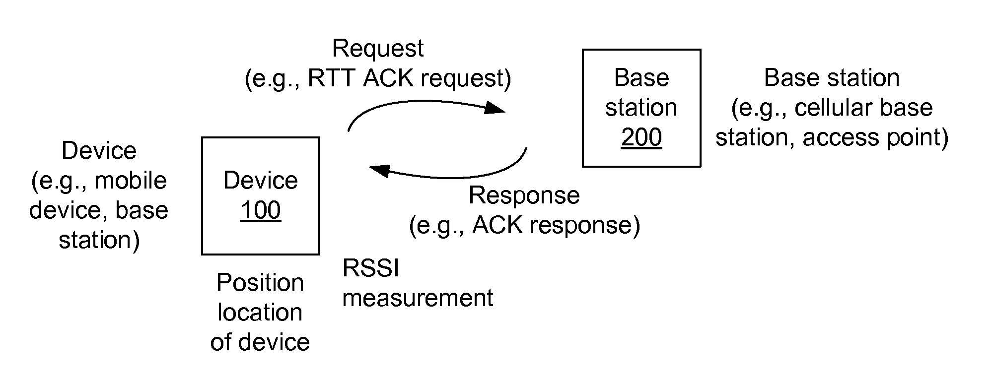
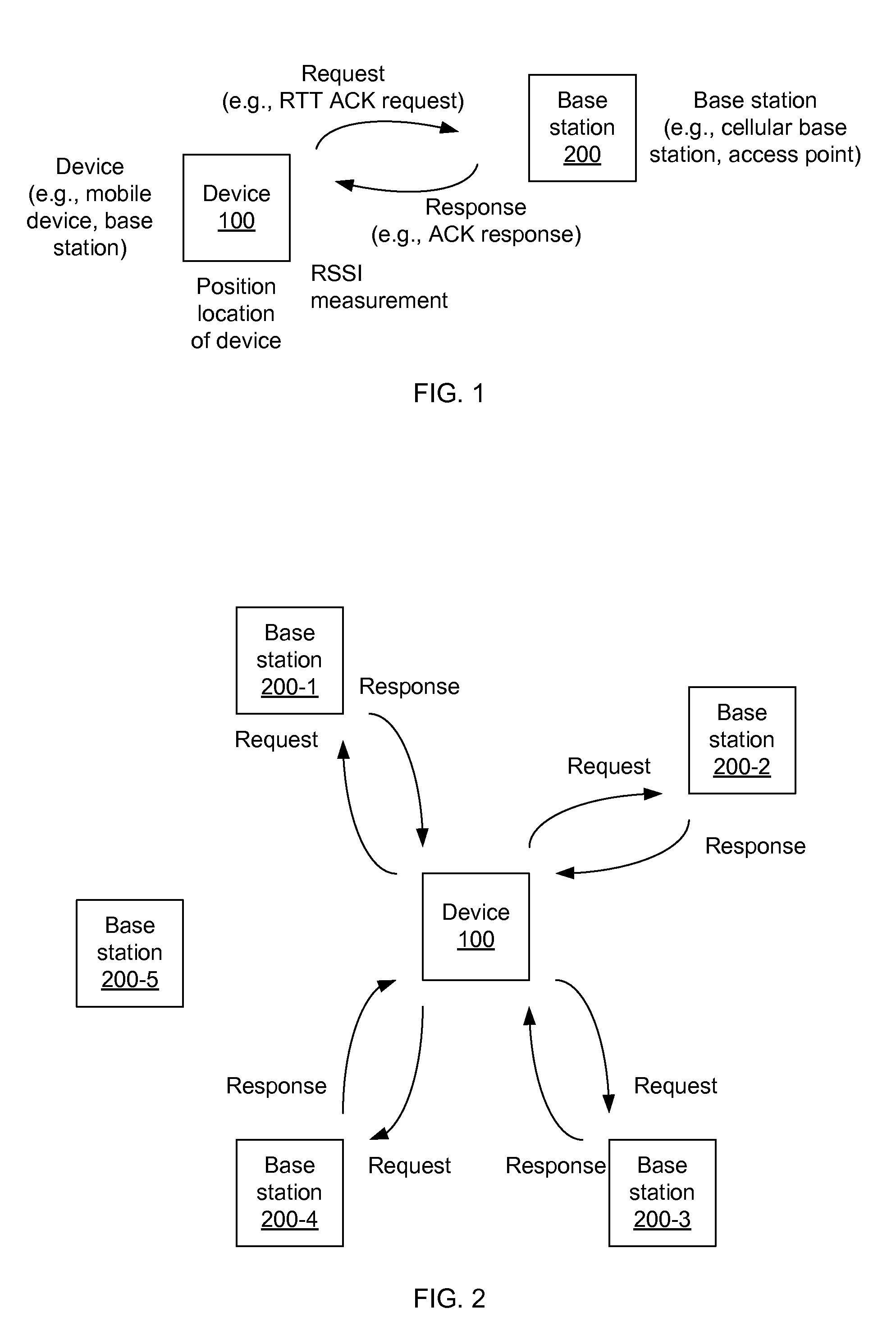
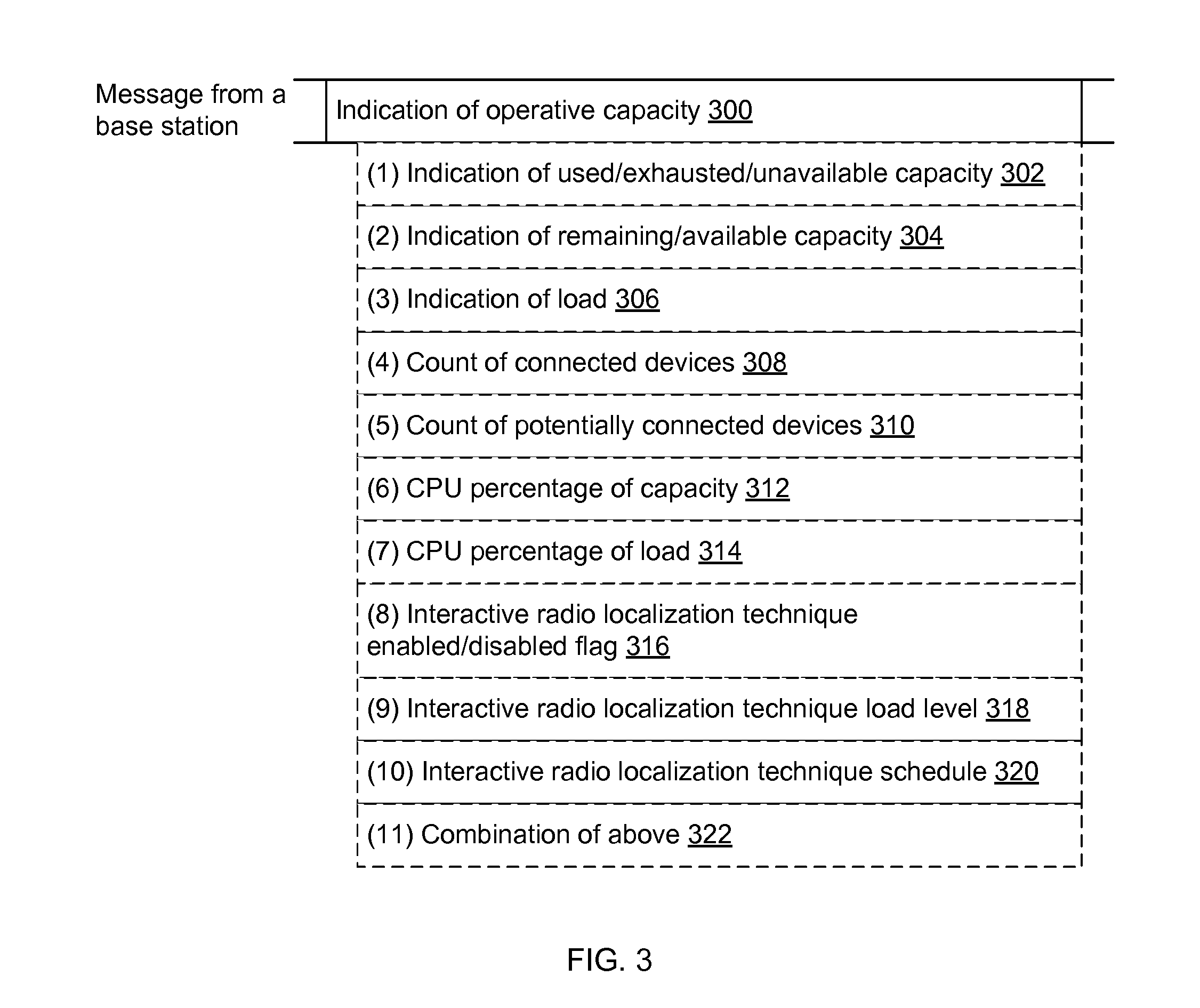
[0020]The detailed description set forth below in connection with the appended drawings is intended as a description of various aspects of the present disclosure and is not intended to represent the only aspects in which the present disclosure may be practiced. Each aspect described in this disclosure is provided merely as an example or illustration of the present disclosure, and should not necessarily be construed as preferred or advantageous over other aspects. The detailed description includes specific details for the purpose of providing a thorough understanding of the present disclosure. However, it will be apparent to those skilled in the art that the present disclosure may be practiced without these specific details. In some instances, well-known structures and devices are shown in block diagram form in order to avoid obscuring the concepts of the present disclosure. Acronyms and other descriptive terminology may be used merely for convenience and clarity and are not intended...


PUM


Abstract

Systems, apparatus and methods for selecting a base station or a set of base stations for RTT measurements, or other interactive radio localization technique, to determine a position fix of a device are presented. The method imposes a processing load on only inactive or less active base stations. Busy or busier base stations are not used in the interactive radio localization technique. By imposing a processing load on only less active base stations, transmitting devices may be under loaded and encounter a more uniform processing delay, and thus provide a more accurate measurement resulting in a more accurate position fix.

Description

BACKGROUND[0001]I. Field of the Invention[0002]This disclosure relates generally to systems, apparatus and methods for position location of devices, and more particularly to determining a position fix with radio measurements from base stations selected based on an indication of base station capacity.[0003]II. Background[0004]A satellite positioning system (SPS), such as the Global Positioning System (GPS), Galileo, and GLONASS, for example, typically provides position, velocity, and / or time information. In a particular implementation, an SPS may comprise a Global Navigation Satellite System (GNSS). A variety of receivers have been designed to decode signals transmitted from satellite vehicles (SVs) of an SPS to determine position, velocity, and / or time. In general, to decipher such signals and compute a final position, a receiver may first acquire signals from SVs that are in view, measure and track the received signals, and recover navigational data from the signals. By accurately ...

Claims


Application Information

Patent Timeline
IPC IPC(8): H04W4/02H04W24/08H04L12/26H04W48/18
CPCH04W4/023H04L43/0864H04W24/08H04W48/18G01S5/14
Inventor BHAVSAR, VRAJESHCHEN, YINDAS, SAUMITRA MOHAN
Owner QUALCOMM INC
Why Eureka
Try Eureka