Systems and methods for space-based geolocation of vessels using maritime signals transmitted therefrom

a technology of maritime signals and systems, applied in the field of maritime systems, can solve problems such as the inability to transmit their own locations to the vessels

Inactive Publication Date: 2017-04-13
HARRIS CORP
View PDF4 Cites 25 Cited by
  • Summary
  • Abstract
  • Description
  • Claims
  • Application Information

AI Technical Summary

Problems solved by technology

The AIS base stations and satellites comprise AIS receivers, and therefore c...

Method used


Image

  • Systems and methods for space-based geolocation of vessels using maritime signals transmitted therefrom
  • Systems and methods for space-based geolocation of vessels using maritime signals transmitted therefrom
  • Systems and methods for space-based geolocation of vessels using maritime signals transmitted therefrom

Examples


Embodiment Construction

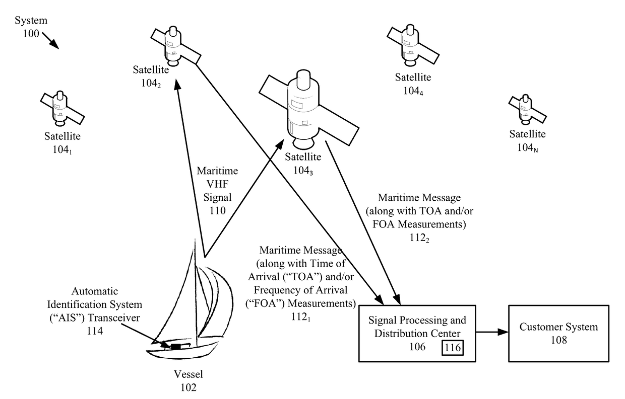
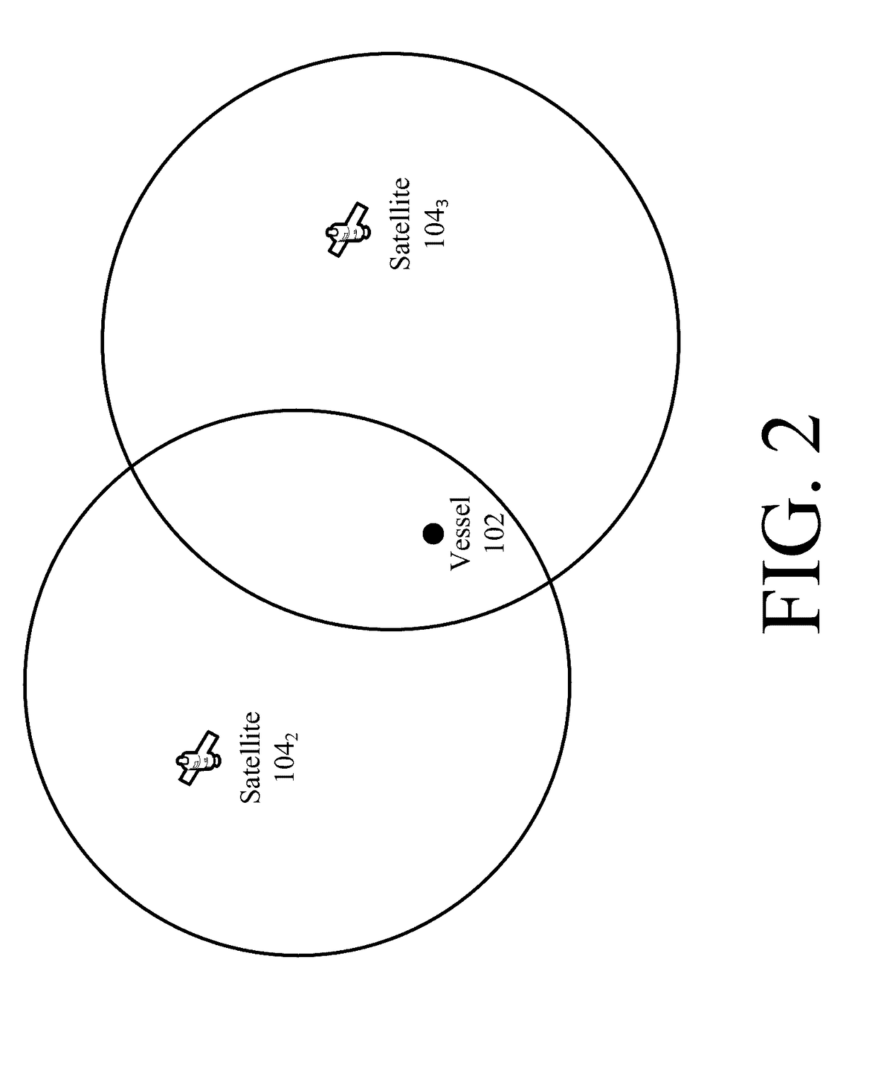
[0016]The invention is described with reference to the attached figures. The figures are not drawn to scale and they are provided merely to illustrate the instant invention. Several aspects of the invention are described below with reference to example applications for illustration. It should be understood that numerous specific details, relationships, and methods are set forth to provide a full understanding of the invention. One having ordinary skill in the relevant art, however, will readily recognize that the invention can be practiced without one or more of the specific details or with other methods. In other instances, well-known structures or operations are not shown in detail to avoid obscuring the invention. The invention is not limited by the illustrated ordering of acts or events, as some acts may occur in different orders and / or concurrently with other acts or events. Furthermore, not all illustrated acts or events are required to implement a methodology in accordance wi...


PUM


Abstract

Systems (100) and methods (400) for space-based geolocation. The methods involve receiving by at least two first satellites a maritime signal transmitted from a vessel on or near Earth. The first satellites are deployed in space so as to have overlapping coverage areas. The maritime signal (received at the at least two first satellites) is then used to determine a geographic location of the vessel on Earth using at least one of a Time Difference of Arrival (“TDOA”) and a Frequency Difference of Arrival (“FDOA”).

Description

BACKGROUND OF THE INVENTION[0001]Statement of the Technical Field[0002]This document relates to maritime systems. More particularly, this document concerns systems and methods for space-based geolocation of vessels using maritime signals transmitted therefrom.[0003]Description of the Related Art[0004]Automatic Identification Systems (“AISs”) are well known in the art. The AISs typically allow vessels (e.g., ships) to view and track marine traffic in a surrounding area. AISs have many applications. For example, AISs can be employed for collision avoidance, fishing fleet monitoring and control, vessel traffic services, maritime security, navigation services, search and rescue, accident investigation, and fleet and cargo tracking[0005]In this regard, an AIS is an automatic tracking system used on ships and by Vessel Traffic Services (“VTSs”) for identifying and locating vessels in a given geographic area or around the globe. A vessel's identification and location are tracked by exchang...

Claims


Application Information

Patent Timeline
IPC IPC(8): G01S19/46
CPCG01S19/46G01S5/06G01S5/0249G01S5/0246G01S2205/04G01S5/0244
Inventor PETKUS, ERICDYSON, TIMOTHY F.PLEW, JASONBRUCKMEYER, JOSHUA P.ZAHM, CHARLES
Owner HARRIS CORP
Why Eureka
Try Eureka