Traffic Risk Avoidance for a Route Selection System

a route selection and traffic risk technology, applied in surveying, navigation, navigation instruments, etc., can solve the problems of hazardous areas or routes, prone to induce vehicle collisions, and other transportation infrastructure, and achieve the effect of avoiding the traversing area and facilitating routing or re-routing

Active Publication Date: 2017-10-12
STATE FARM MUTUAL AUTOMOBILE INSURANCE
View PDF0 Cites 71 Cited by
  • Summary
  • Abstract
  • Description
  • Claims
  • Application Information

AI Technical Summary

Benefits of technology

[0012]The systems and methods may further transmit the selected travel route to an electronic device (e.g., mobile device, an on-board computer, wearable electronics, or a navigator) associated with a vehicle, operator or passenger of a vehicle, pedestrian, bicyclist, and the likes to facilitate routing or re-routing that avoids traversing the area based upon the risk index or based upon a lower aggregate risk for a specified route, via wireless communication or data transmission over one or more radio links or wireless communication channels.
[0016]In some embodiments, the instructions may further cause the processor to transmit the selected travel route to an electronic device (e.g., mobile device, an on-board computer, wearable electronics, and a navigator) associated with a vehicle, operator or passenger of a vehicle, pedestrian, bicyclist, and the likes to facilitate routing or re-routing that avoids traversing the area based upon the risk index, via wireless communication or data transmission over one or more radio links or wireless communication channels.

Problems solved by technology

Hazardous areas (e.g., high risk intersections, road segments or portions of certain roads, bridges, abnormal traffic patterns, exit ramps, circular traffic flows, road construction areas, parking lots, and other transportation infrastructure) are prone to induce, or be associated with, vehicle collisions.
If the risk index for the area, or if the aggregated risk index over a specified route exceeds a predetermined threshold, the area or route may be classified as hazardous.

Method used


Image

  • Traffic Risk Avoidance for a Route Selection System
  • Traffic Risk Avoidance for a Route Selection System
  • Traffic Risk Avoidance for a Route Selection System

Examples


Embodiment Construction

[0031]The present embodiments may generally relate to reducing vehicle collisions, and particularly, inter alia, to identifying or selecting a travel route for a vehicle that avoids traversing the areas that are prone to vehicle collisions.

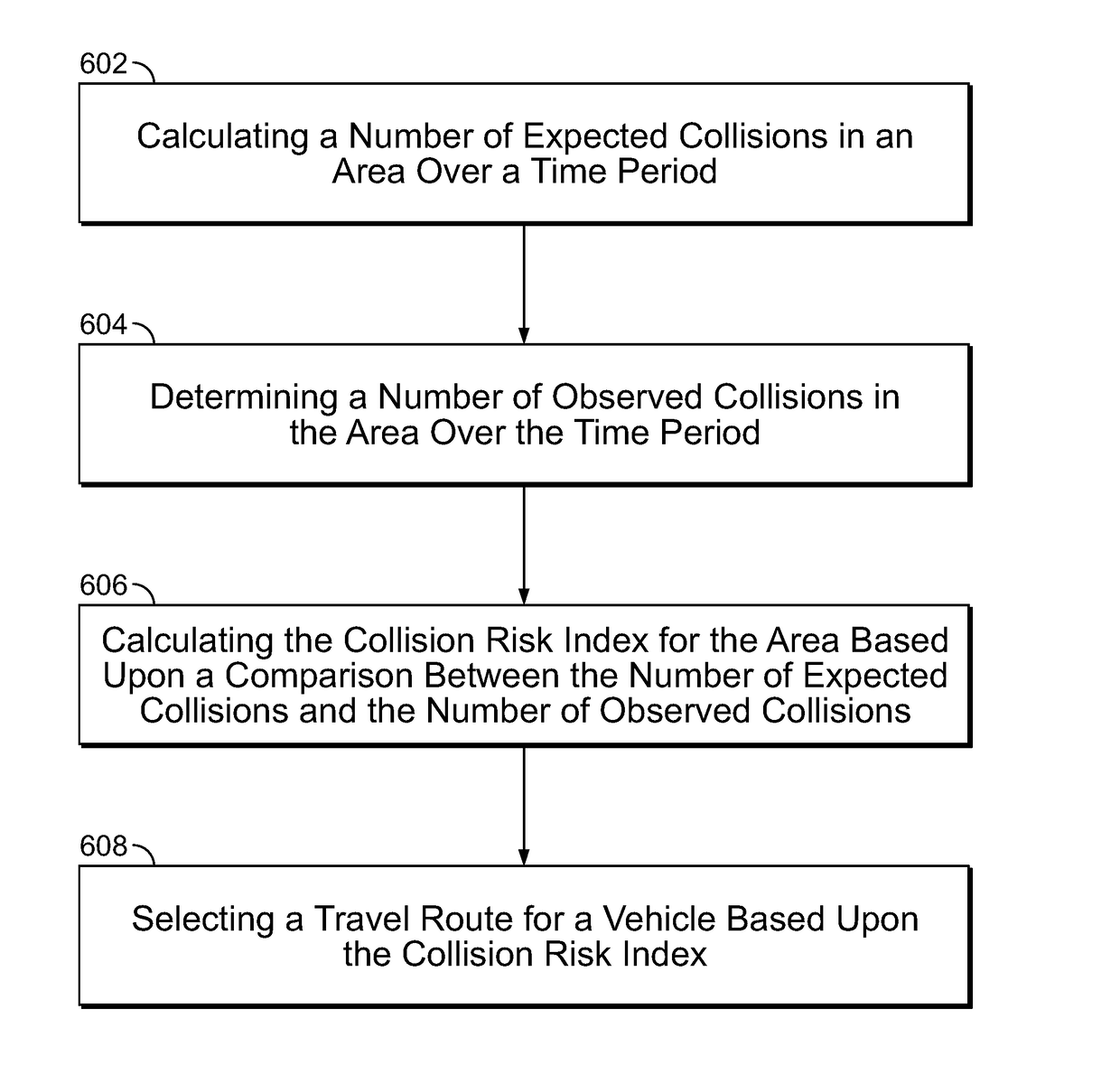
[0032]Hazardous areas (e.g., high risk intersections, road segments or portions of certain roads, bridges, abnormal traffic patterns, exit ramps, circular traffic flows, road construction areas, parking lots, and other transportation infrastructure) are prone to induce, or be associated with, vehicle collisions. One way to measure how hazardous an area is by calculating a risk index for the area, which quantifies how prone the area is to vehicle collisions. Calculating the risk index may include various methods and / or factors, including those discussed elsewhere herein. Subsequent to calculating the risk index, a travel route for a vehicle may selected based upon the aggregate risk index.

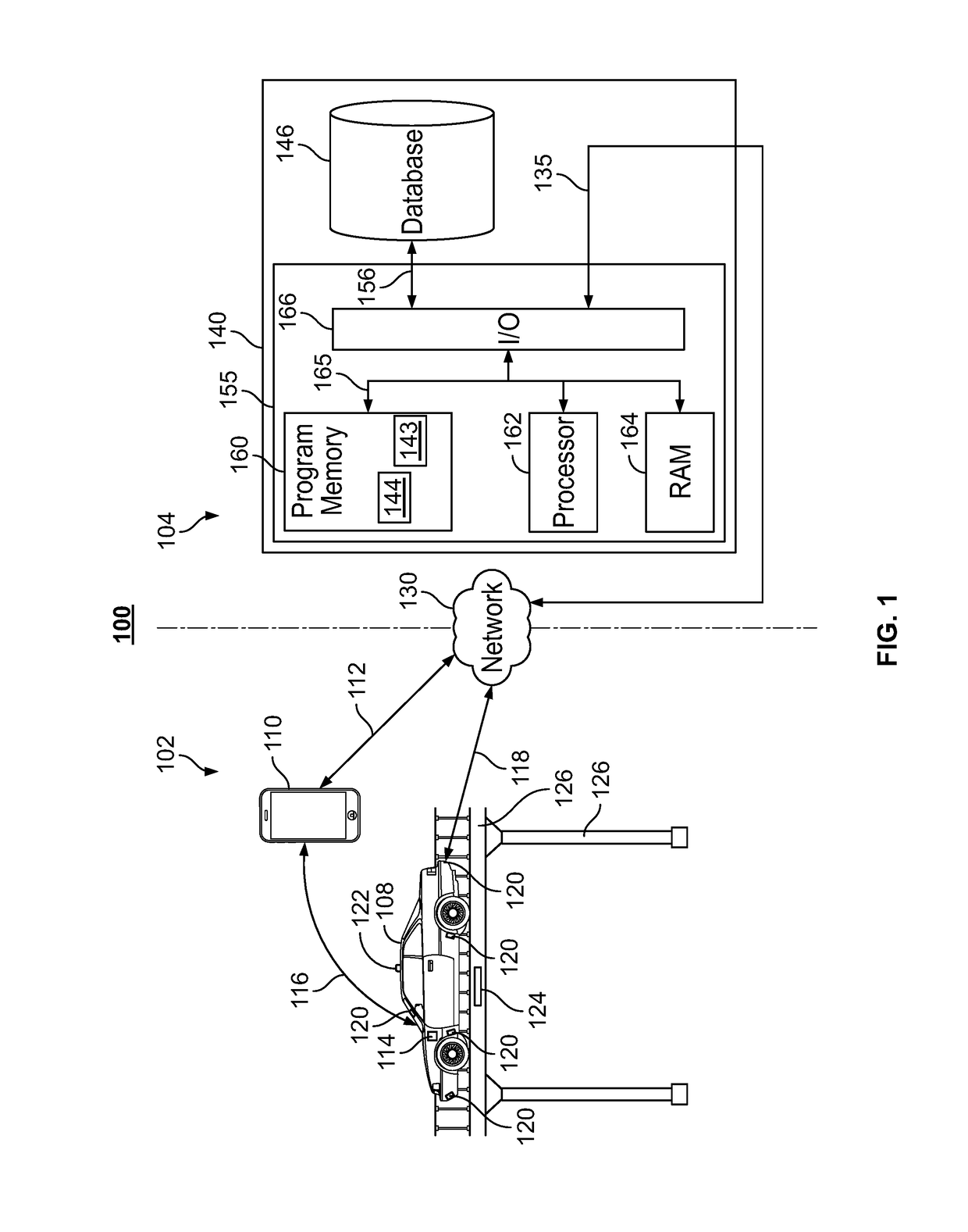
[0033]FIG. 1 illustrates a block diagram of an interconnecte...


PUM


Abstract

Systems and methods relate to, inter alia, calculating a number of expected collisions in an area over a time period. The systems and methods may further determine a number of observed collisions in the area over the time period. The systems and methods may further calculate a risk index for the area based upon a comparison between the number of expected collisions and the number of observed collisions. The systems and methods may further select a travel route for a vehicle based upon the risk index.

Description

CROSS REFERENCE TO RELATED APPLICATIONS[0001]The present disclosure claims the benefit of U.S. Provisional Patent Application No. 62 / 321,005, entitled “Device for Detecting and Visualizing High-Risk Intersections and Other Areas” filed on Apr. 11, 2016, U.S. Provisional Patent Application No. 62 / 321,010, entitled “Analyzing Auto Claim and Vehicle Collision Data to Identify Hazardous Areas and Reduce Vehicle Collisions” filed on Apr. 11, 2016, and U.S. Provisional Patent Application No. 62 / 340,302, entitled “Analyzing Auto Claim and Vehicle Collision Data to Identify Hazardous Areas and Reduce Vehicle Collisions” filed on May 23, 2016, all of which are hereby incorporated herein by reference in their entirety.TECHNICAL FIELD[0002]The present disclosure relates generally to reducing vehicle collisions. More particularly, the present disclosure relates to providing travel routes that avoid hazardous areas, thereby reducing future vehicle collisions and personal risk.BACKGROUND[0003]Dri...

Claims


Application Information

Patent Timeline
Patent Type & Authority Applications(United States)
IPC IPC(8): G01C21/34
CPCG01C21/3492G01C21/3461
Inventor NEPOMUCENO, JOHN A.SHAH, RAJIV C.CHAN, LEO NELSONCIELOCHA, STEVENLYONS, ROXANEMEGYESE, MATTHEW S.LEISE, WILLIAM J.KELLETT, JENNIFER CRISWELLGAUDIN, KRISTOPHER KEITHCRAWFORD, JENNIFER L.MYERS, JEREMYMATESEVAC, III, EDWARD P.
Owner STATE FARM MUTUAL AUTOMOBILE INSURANCE
Why Eureka
Try Eureka