Method for increasing the spatial resolution of a weather forecast

US20180188417A1Active Publication Date: 2018-07-05UBIMET GMBH

Image

  • Method for increasing the spatial resolution of a weather forecast
  • Method for increasing the spatial resolution of a weather forecast
  • Method for increasing the spatial resolution of a weather forecast

Examples


Embodiment Construction

[0041]Definition of Terms

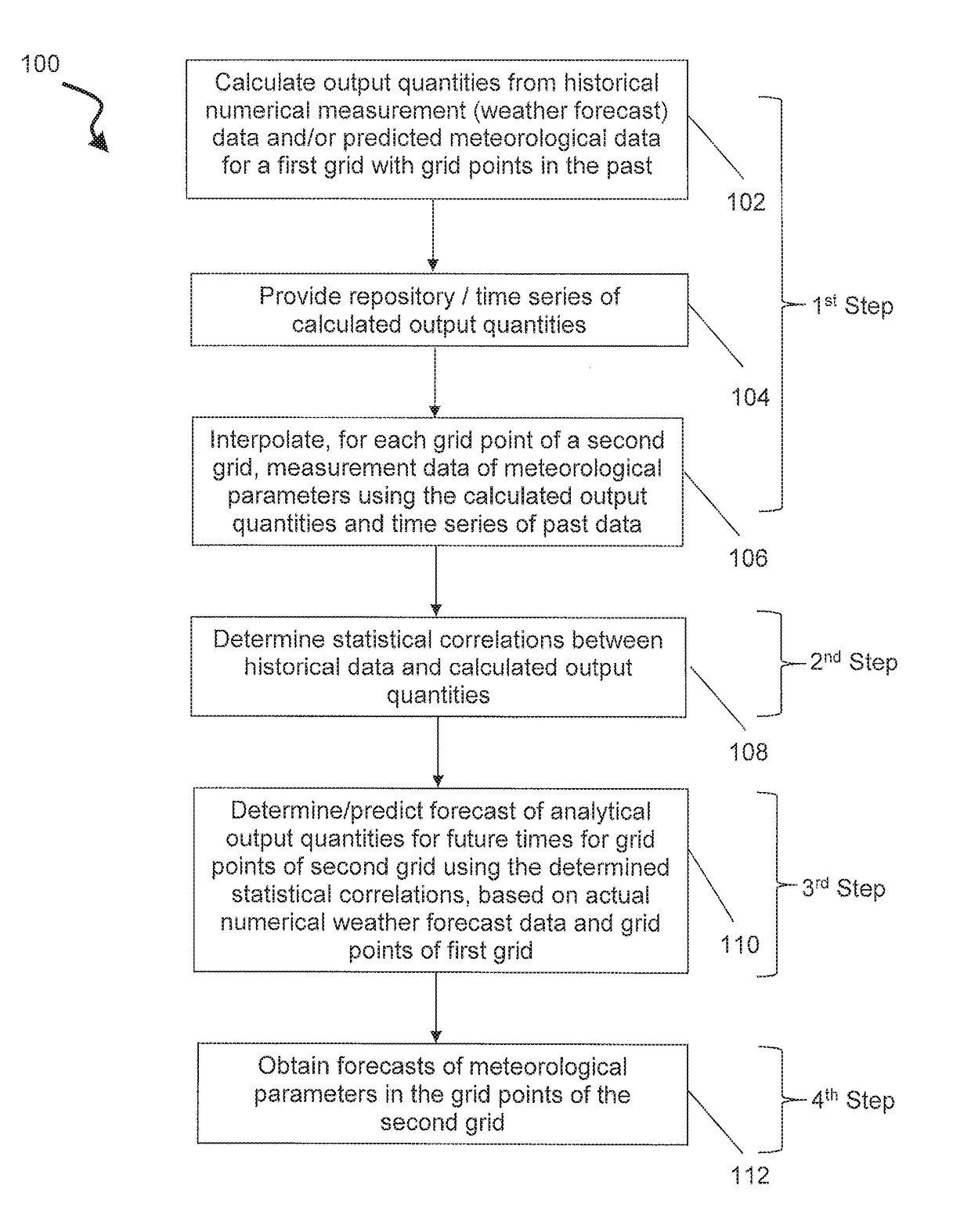
[0042]In meteorology, a number of methods are used to describe and / or model the state of the atmosphere and to determine therefrom meteorological quantities by computational methods. In the description of the present invention, the relevant meteorological methods are defined as follows.

[0043]By “meteorological analysis”, a description as precise as possible of the instantaneous state of the atmosphere at a defined time (in the past) is to be understood. A “meteorological analysis method” is a method that serves to interpolate measurements irregularly distributed in space by incorporating additional information. In the most general case, these are relations assigning fields of these parameters to a finite number of measurements of defined meteorological parameters.

[0044]By “downscaling”, a spatial interpolation of meteorological quantities known on a regular grid is understood. Such interpolation is performed by incorporating additional information known on a...


PUM


Abstract

In a method for increasing the spatial resolution of a weather forecast, in which forecast predicted meteorological parameters are available for grid points of a first grid and the predicted meteorological parameters are interpolated to grid points of a second grid so as to obtain interpolated meteorological parameters, wherein the grid points of the second grid have a higher spatial resolution than the grid points of the first grid, a statistical postprocessing method is used to predict at least one output quantity of an analysis method by which forecast meteorological parameters can be interpolated to the grid points of the second grid.

Description

CROSS REFERENCE TO RELATED APPLICATION(S)[0001]This application claims priority to European Patent Application No. 17450001.7, filed Jan. 3, 2017, the contents of said applications being incorporated herein by reference in its entirety.BACKGROUNDField of the Invention[0002]The invention relates to a method, in particular a computer-implemented method, for increasing the spatial resolution of a weather forecast, in which predicted meteorological parameters are available for grid points of a first grid and the predicted meteorological parameters are interpolated to grid points of a second grid so as to obtain interpolated meteorological parameters, wherein the grid points of the second grid have a higher spatial resolution than the grid points of the first grid. The parameter fields present on the second grid may comprise more small-scale information than in the application of a simple interpolation technique.[0003]Furthermore, the invention relates to a computer program product compr...

Claims


Application Information

Patent Timeline
05 Jul 2018
Publication
US20180188417A1
IPC
G01W1/10; G01W1/02
CPC
G01W1/10; G01W1/02; G01W1/00; G06F30/20
Inventors
SPATZIERER, MANFRED