System and method for identifying parking spaces and parking occupancy based on satellite and/or aerial images

a technology of satellite and aerial images, applied in the field of system and method for identifying parking spaces and parking occupancy based on satellite and/or aerial images, can solve the problems of not being able to extract detailed information from street parking can be notoriously difficult to locate, and the resolution of satellite images that are publically and/or commercially available is generally not high enough to solve the problem of parking problems,

a technology of satellite and aerial images, applied in the field of system and method for identifying parking spaces and parking occupancy based on satellite and/or aerial images, can solve the problems of not being able to extract detailed information from street parking can be notoriously difficult to locate, and the resolution of satellite images that are publically and/or commercially available is generally not high enough to solve the problem of parking problems,

US20210064892A1Active Publication Date: 2021-03-04PARKBOB GMBH

Image

  • System and method for identifying parking spaces and parking occupancy based on satellite and/or aerial images
  • System and method for identifying parking spaces and parking occupancy based on satellite and/or aerial images
  • System and method for identifying parking spaces and parking occupancy based on satellite and/or aerial images

Examples


Embodiment Construction

TS

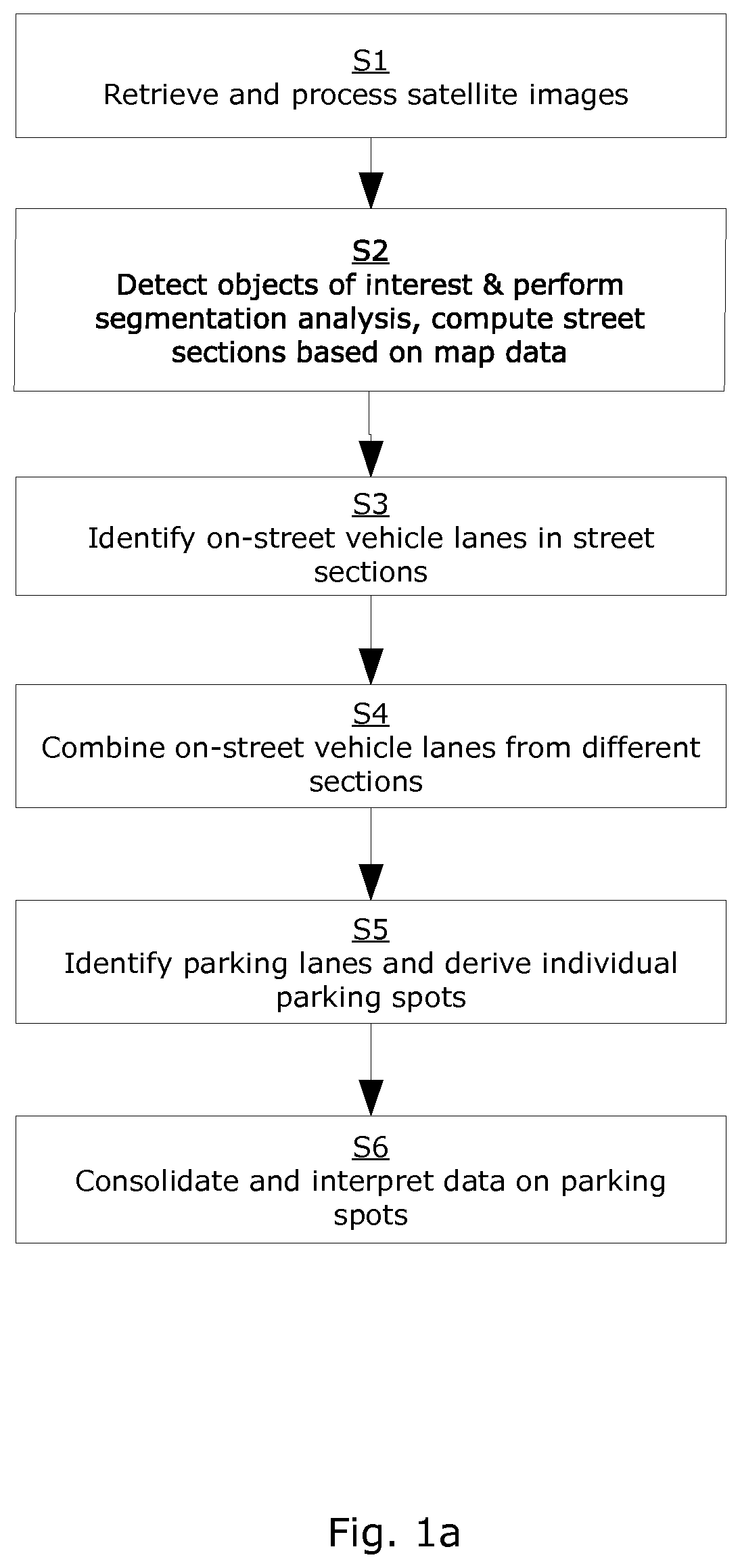
[0193]FIG. 1a depicts an embodiment of a method according to one aspect of the invention. The method comprises using satellite images to identify on-street parking spaces. The present method is particularly useful for mapping parking areas in a city, providing an overview of a parking situation to interested parties, or generating forecasts regarding parking occupancy.

[0194]In step S1, satellite images are retrieved and processed. This can comprise retrieving images from a plurality of storage systems such as databases, harmonizing them, quality controlling them, geotagging them and further prepare them to be used as part of the method.

[0195]In step S2, objects of interest are detected in the images. Those typically comprise vehicles, but can also comprise landmarks, buildings, or other objects allowing for further data extraction and use. Furthermore, segmentation analysis is performed on each satellite image.

[0196]That is, a plurality of image surfaces is identified, a plurality...


PUM


Abstract

Methods and system for identifying and evaluating on-street parking spots of an area are disclosed. The method comprises using at least one of satellite and aerial images and map data to identify vehicles, match them to street sections, compute on-street vehicle lanes, consolidate data from a plurality of images and identify parking lanes, as well as parking spots. The described system comprises a memory component, a processing component and an output component. Furthermore, a computer program executable by a computer and a non-transient computer-readable medium for identifying and evaluating on-street parking spots are described.

Description

FIELD[0001]The invention is directed towards identifying street parking spaces and street parking occupancy. The invention is further directed to processing satellite and / or aerial images to detect parking spaces and parking occupancy.INTRODUCTION[0002]The demand for parking spaces is continuously rising along with increasing car ownership. Street parking can be notoriously difficult to locate, particularly in inner city areas, unfamiliar neighborhoods and / or during times when demand is high. Currently, many services exist that provide users with estimates of parking occupancy, based on location, time, historical data and other parameters. To provide users with parking occupancy, such services need to collect data relating to street parking spots in a given region and preferably their typical occupancy. This is currently mainly done by regular manual surveys, street parking sensors or other similar means. Prototypes of using video from CCTV or dashboard cameras have also recently be...

Claims


Application Information

Patent Timeline
04 Mar 2021
Publication
US20210064892A1
IPC
G06K9/00; G06K9/32; G06K9/62
CPC
G06K9/00812; G06K9/00651; G06K9/6215; G06K9/3233; G06K9/00798; G06V20/182; G06V20/586; G06V20/588
Inventors
ADELSBERGER, CHRISTIAN; KASANICKY, IVAN