System and method for updating a geographic database using satellite imagery

a geographic database and satellite imagery technology, applied in the field of process for updating a geographic database, can solve the problems of insufficient accuracy of geographic data, inability to accurately update geographic data, and inability to collect information for a geographic databas

Inactive Publication Date: 2005-03-29
HERE GLOBAL BV
View PDF15 Cites 122 Cited by
  • Summary
  • Abstract
  • Description
  • Claims
  • Application Information

AI Technical Summary

Problems solved by technology

Collecting information for a geographic database is a significant task.
Just like conventional printed maps, geographic databases become out-of-date.
These end users may discover that certain geographic data are not correct or are inaccurate.
End users can report perceived errors by telephone or by the Internet.
Sometimes the err

Method used


Image

  • System and method for updating a geographic database using satellite imagery
  • System and method for updating a geographic database using satellite imagery
  • System and method for updating a geographic database using satellite imagery

Examples


Embodiment Construction

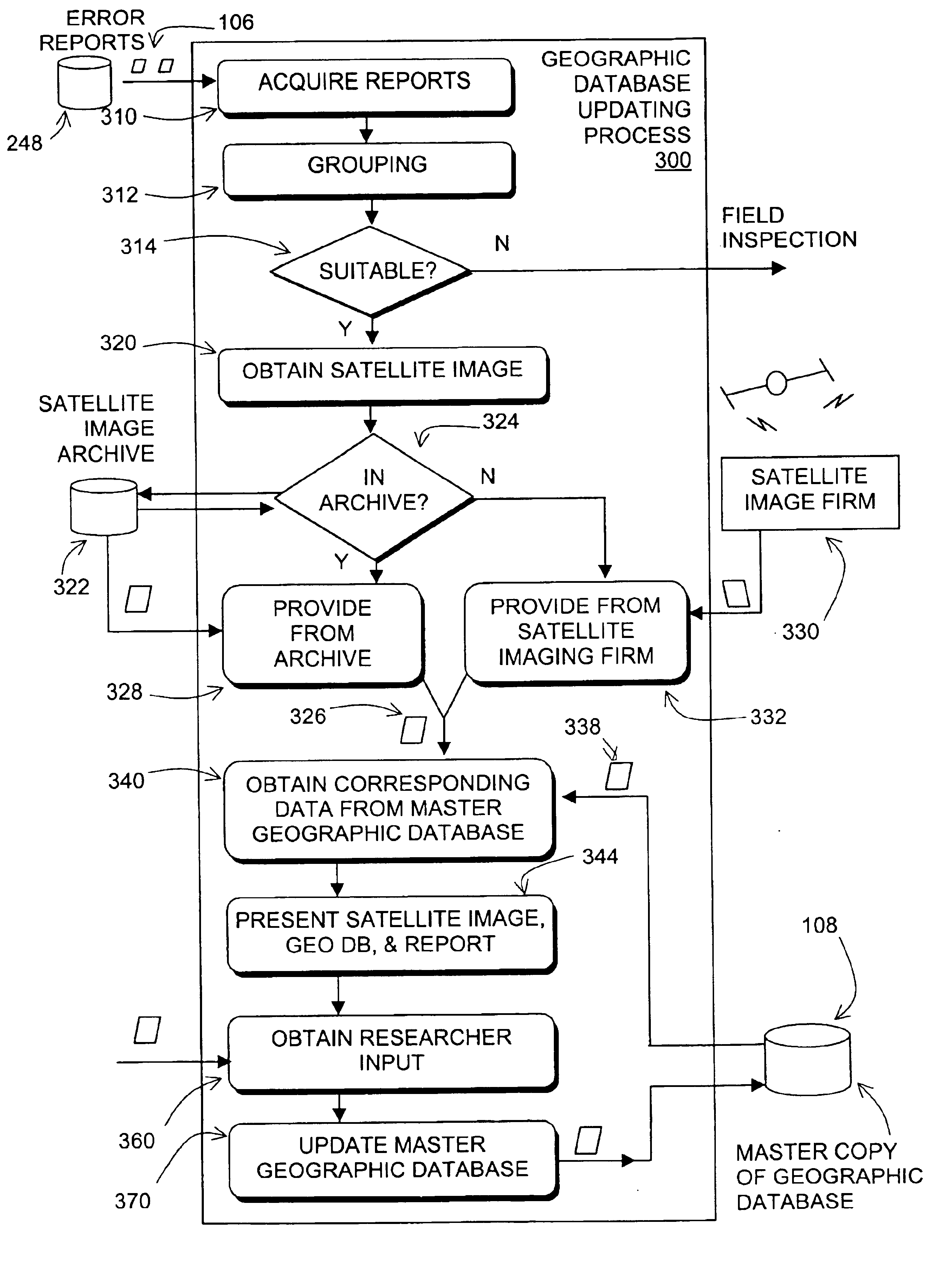
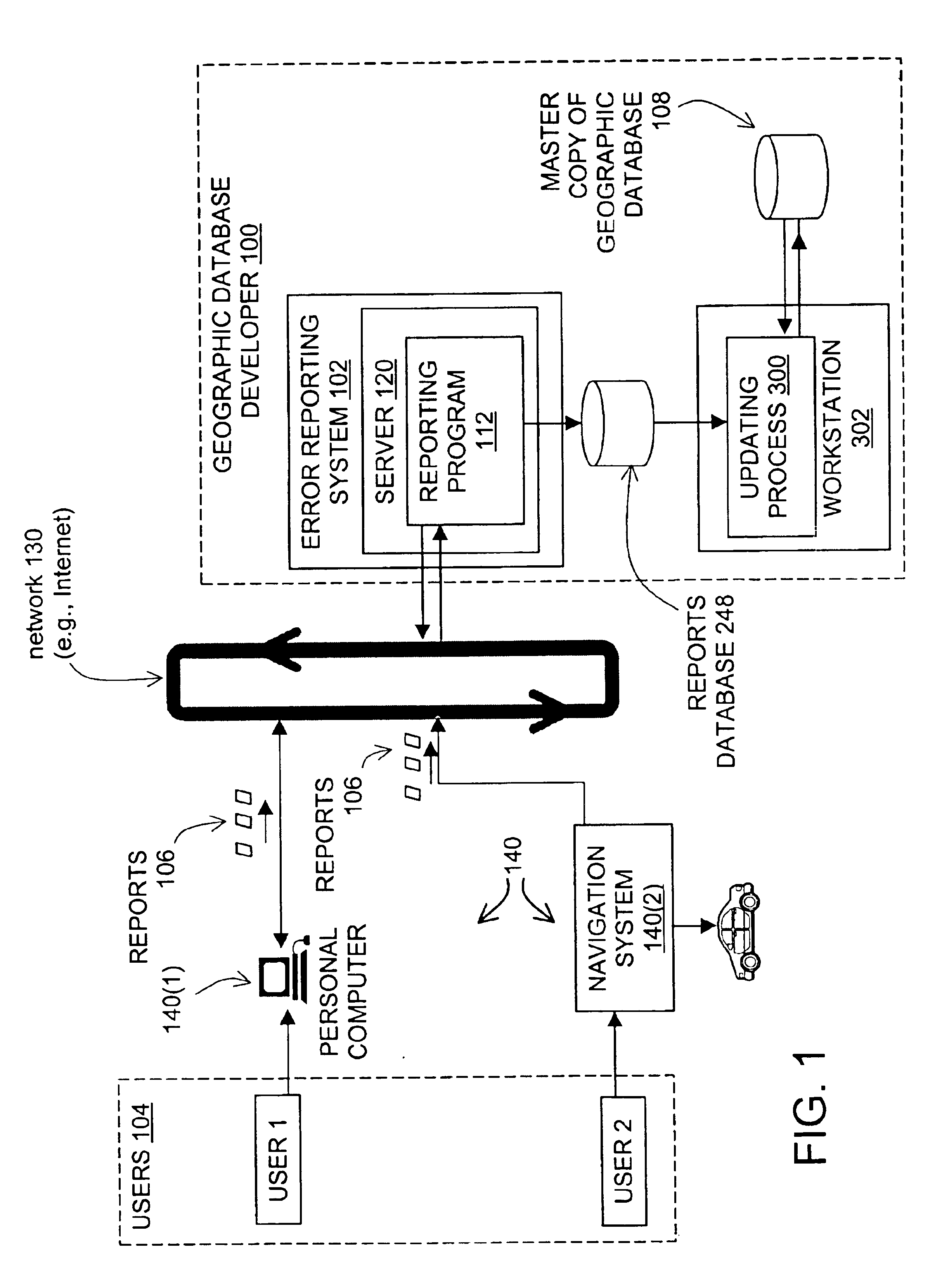
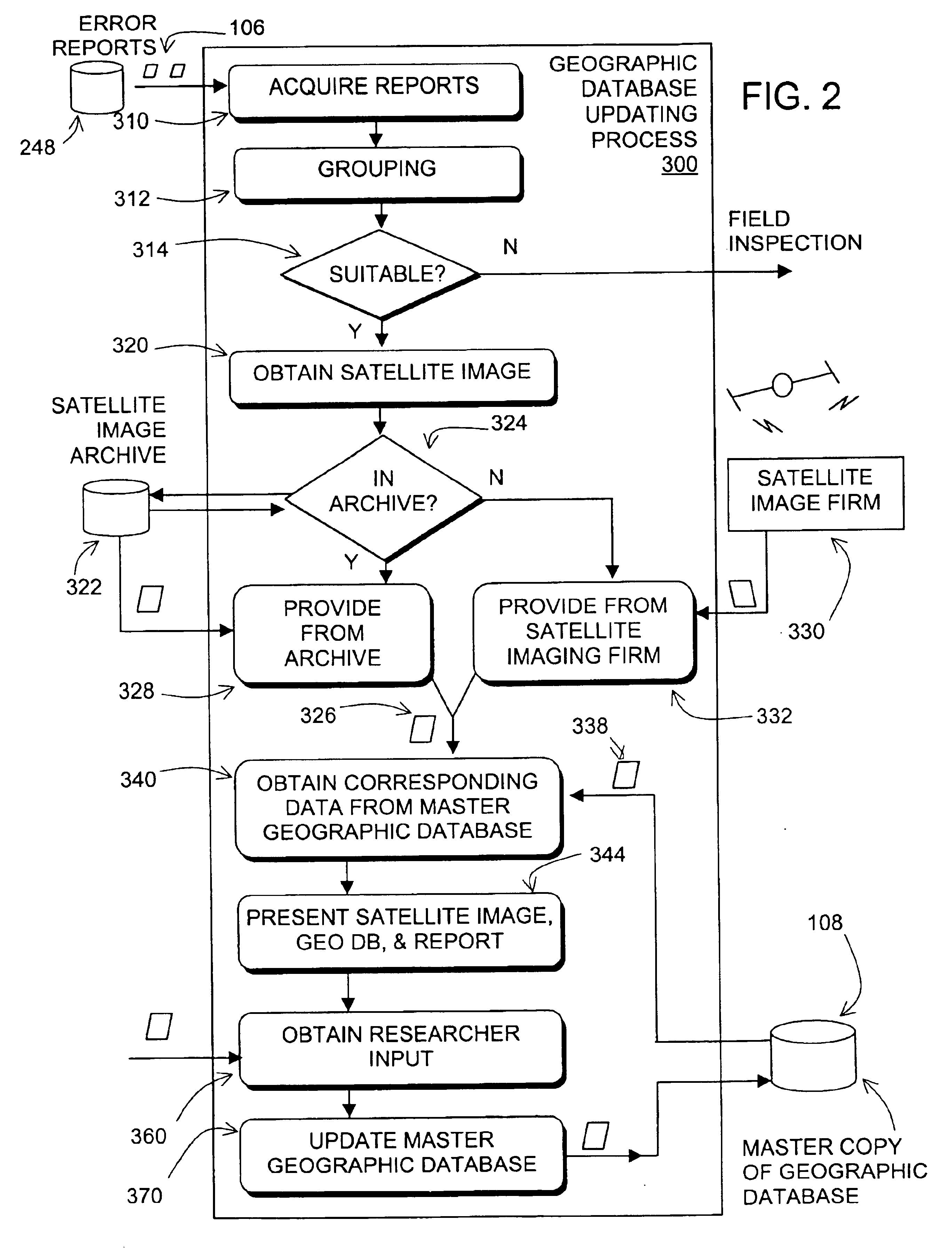
Referring to FIG. 1, a geographic database developer 100 operates an error reporting system 102. The error reporting system 102 enables end users 104 (e.g., persons who obtain navigation-related or map-related services from navigation systems or from on-line providers of navigation services) to submit reports 106 relating to perceived errors that the end users discover in the geographic data used in the navigation-related or map-related services that are obtained from navigation systems or from on-line providers of navigation services. The reports 106 are used by the geographic database developer 100 to update a master copy 108 of the geographic database. After being updated, the master copy 108 of the geographic database is used to make derived geographic database products that are subsequently used in navigation systems or by on-line navigation services providers.

The error reporting system 102 may provide several different ways that the end users 104 can use to report errors. Thes...


PUM


Abstract

A reporting program and system for updating a master copy of a geographic database is disclosed. According to the method and system, reports are obtained that relate to data contained in a geographic database. Satellite images of the geographic locations represented by the data in the reports are obtained. The satellite images are analyzed to confirm a need to make changes to the master copy of the geographic database based on the reports. After confirming the need to make, the changes, the master copy of the geographic database is updated.

Description

BACKGROUND OF THE INVENTIONThe present invention relates to a process for updating a geographic database and more particularly, the present invention relates to a process and system that uses satellite imagery for verifying and processing updates to a master copy of a geographic database.Geographic databases have various uses. Geographic databases are used in in-vehicle navigation systems, personal computers, networked computing environments, and various other kinds of platforms, as well as on the Internet. Geographic databases are used with various kinds of applications to provide various functions including map display, route calculation, route guidance, truck fleet deployment, traffic control, electronic yellow pages, emergency services, and so on.In order to provide these kinds of functions, a geographic database includes data that represent geographic features in a covered geographic region. Geographic databases include details about represented geographic features, such as the...

Claims


Application Information

Patent Timeline
IPC IPC(8): G06F17/00G06F7/00G06F17/30
CPCG06F17/30241Y10S707/99931Y10S707/918Y10S707/99945Y10S707/99948Y10S707/99953G06F16/29
Inventor DORUM, OLE HENRYHANSON, JOHNKAPLAN, LAWRENCE M.
Owner HERE GLOBAL BV
Why Eureka
Try Eureka