Airborne based monitoring

a technology of airborne monitoring and monitoring system, applied in the field of measurement system, can solve the problems of inaccurate assumption, circularity problems, and pressure altitude measurement, and achieve the effect of optimizing aircraft routing and improving weather forecasts

Inactive Publication Date: 2005-08-30
HONEYWELL INT INC
View PDF27 Cites 64 Cited by
  • Summary
  • Abstract
  • Description
  • Claims
  • Application Information

AI Technical Summary

Benefits of technology

[0009]Recorded data may be transmitted in real time to ground monitoring stations. In an embodiment, ground monitoring stations are capable of compiling data from a plurality of aircraft to generate real-time three-dimensional maps of weather conditions aloft. Weather forecasters, for example, could use this more detailed and accurate meteorological data to improve weather forecasts. The data could also provide excellent information to help optimize aircraft routing.

Problems solved by technology

A pressure altitude measurement, however, may not reflect the true altitude of the aircraft because the measurement is based on the assumption that atmospheric pressure is solely a function of altitude.
This assumption may be incorrect—as other factors may alter the atmospheric pressure.
Thus, circularity problems arise when attempting to obtain a measure of atmospheric conditions as a function of altitude.

Method used


Image

  • Airborne based monitoring
  • Airborne based monitoring
  • Airborne based monitoring

Examples


Embodiment Construction

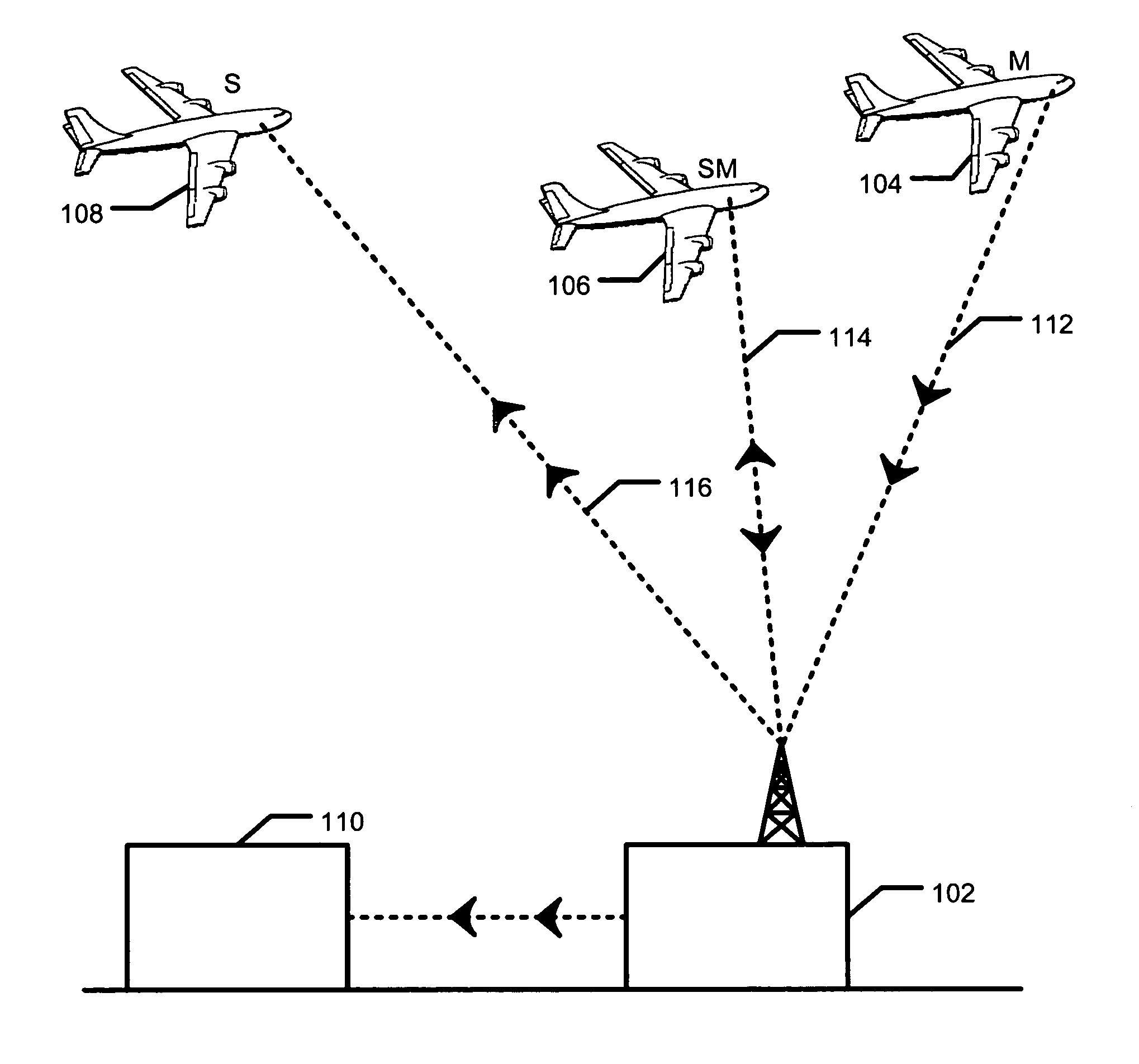
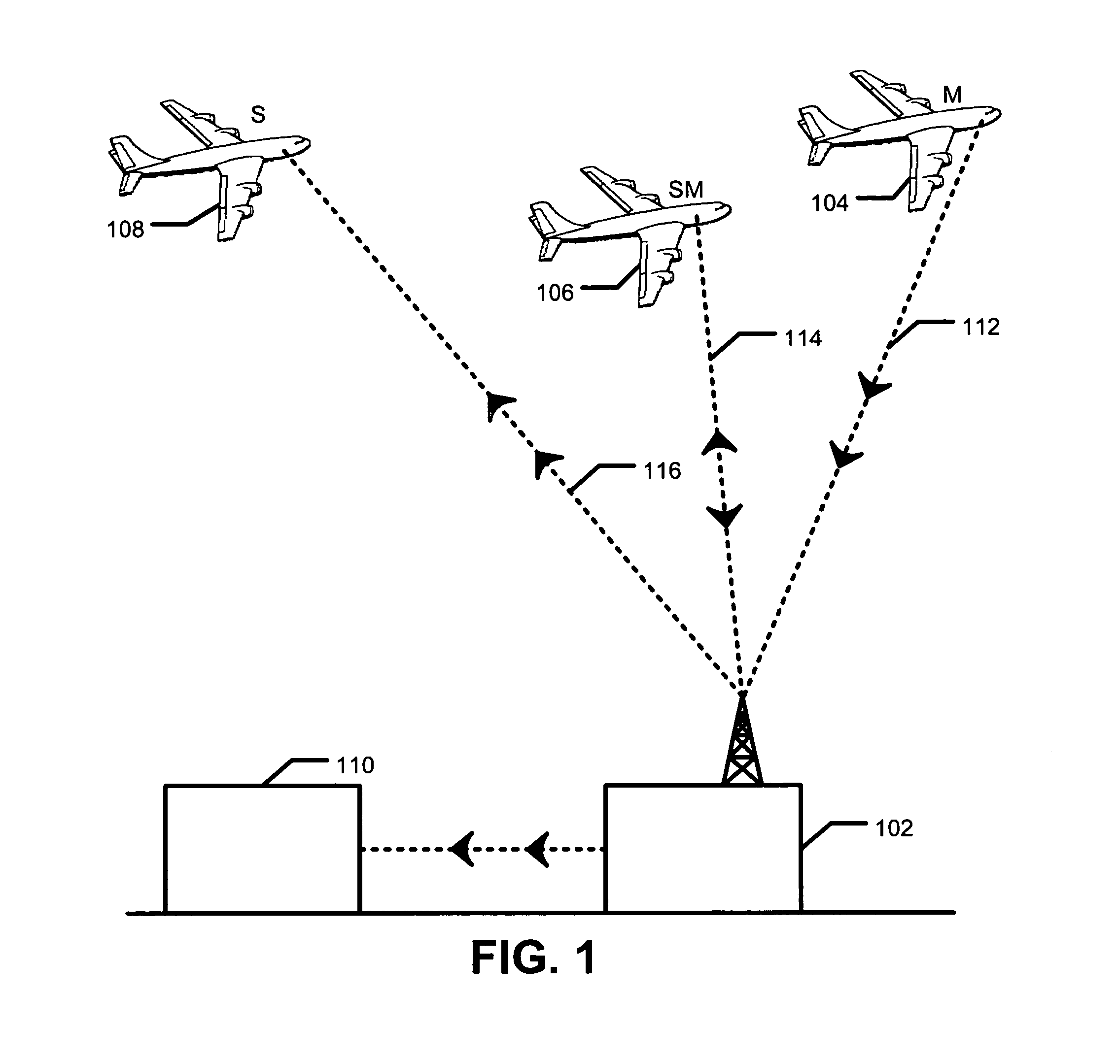
[0016]FIG. 1 is a schematic illustration of an exemplary embodiment of an airborne monitoring system. In particular, FIG. 1 demonstrates the communication pathways of the exemplary embodiment. Three aircraft 104, 106, and 108 are shown and are labeled M, SM, and S to designate their respective functionality. M-aircraft 104 is labeled M because it operates as a monitoring airplane that monitors weather conditions and transmits recorded conditions and the corresponding date, time, location and altitude tags to a ground based processing center 102 via a wireless downlink 112.

[0017]In comparison, S-aircraft 108 is labeled S to indicate that it operates as a subscriber or user. S-aircraft 108 receives indicia of upcoming weather conditions via a wireless uplink 116 from the ground based processing center 102. SM-aircraft 106 operates as both a subscriber and a monitor and is thus labeled SM. SM-Aircraft 106 both sends and receives weather information and thus has a two-way data communica...


PUM


Abstract

A weather monitoring and prediction system that uses a fleet of aircraft to obtain data. Each aircraft has a local air data system that facilitates the measurement, recordation, and transmittal of local atmospheric data such as barometric pressure, and the corresponding temporal, positional, and altitudinal data. The data is electronically transmitted from each aircraft to a ground based processing system where it is stored. The data may then be transmitted to subscribing users such as aircraft, other weather data systems or to air traffic control centers in either a compiled form or in a raw form. Another embodiment also provides for measuring barometric pressure as a function of altitude at an in-flight aircraft.

Description

CROSS-REFERENCE TO RELATED APPLICATIONS[0001]This application is a continuation of application Ser. No. 10 / 856,288, filed May 28, 2004.FIELD[0002]The present invention relates to a measurement system and method for determining local atmospheric conditions aboard an airborne aircraft.BACKGROUND[0003]Each day hundreds of scheduled flights operated by the major airlines, such as United Airlines, America Airlines, Delta, Northwest, Luftansa, Aer Lingus, and VietNam air traverse routes between cities throughout the world. In addition, cargo carriers, such as the United Post Office, DHL, Federal Express, and United Parcel Service fly routes throughout the world on a daily basis. Aircraft on these regularly scheduled flights travel generally predictable routes at generally predictable times. In addition to these commercial flights, there are numerous charter and general aviation flights, amounting to thousands of aircraft aloft each day, covering a large geographic area and encountering a ...

Claims


Application Information

Patent Timeline
Patent Type & Authority Patents(United States)
IPC IPC(8): G01V3/00G01W1/10
CPCG01W1/10G01W2001/003
Inventor MANFRED, MARKTAYLOR JR., LUCIUS ORVILLEBRAMA, ANTHONY VERNON
Owner HONEYWELL INT INC
Why Eureka
Try Eureka