Normalized and animated inundation maps

a hydrologic and inundation map technology, applied in the field of meteorology and hydrology, can solve the problems of unusable flood warnings provided by the national weather service (nws), many inconveniences, and millions of dollars in damages, and achieve the effect of accurate forecasting and predicting

Active Publication Date: 2005-09-20
USER CENTRIC IP
View PDF20 Cites 53 Cited by
  • Summary
  • Abstract
  • Description
  • Claims
  • Application Information

AI Technical Summary

Benefits of technology

[0011]To overcome limitations in the prior art described above, and to overcome other limitations that will be apparent upon reading and understanding the present specification, the present invention is directed to methods and systems

Problems solved by technology

Each year, floods are a major cause of economic loss and loss of life in the United States, causing millions of dollars in damages each year.
In addition, floods cause much inconvenience to those affected by the flood due to cleanup, temporary or permanent relocation, etc.
Flood warnings provided by the National Weather Service (NWS) are presently not user-friendly.
Because most flood gauge levels are arbitrary, they can be confusing to the general public and even to emergency responders such as fire and police.
These arbitrary readings cause a great deal of confusion and can even be dangerous, as described in Who Decides?
In addition, very few members of the general public know whether they will be affected by a flood based on the textual warning illustrated in FIG. 1 because very few people, if any, are aware of the height of the their location in terms of river stage levels in relation to a specific river gauge.
River gauge information, for the public, only becomes important when there is an imminent threat, by which time it is typically too late to mount an educational program.
Likewise, emergency officials (e.g., police and fire) are also often unaware of potential flood areas, and cannot accurately prepare for potential flooding or emergency response.
While newscasters (e.g., via television) often attempt to provide flood warnings, they are generally limited to a broad verbal indication that flooding is possible, and to take necessary precautions.
However, most in

Method used


Image

  • Normalized and animated inundation maps
  • Normalized and animated inundation maps
  • Normalized and animated inundation maps

Examples


Embodiment Construction

[0023]In the following description of the various embodiments, reference is made to the accompanying drawings, which form a part hereof, and in which is shown by way of illustration various embodiments in which the invention may be practiced. It is to be understood that other embodiments may be utilized and structural and functional modifications may be made without departing from the scope of the present invention.

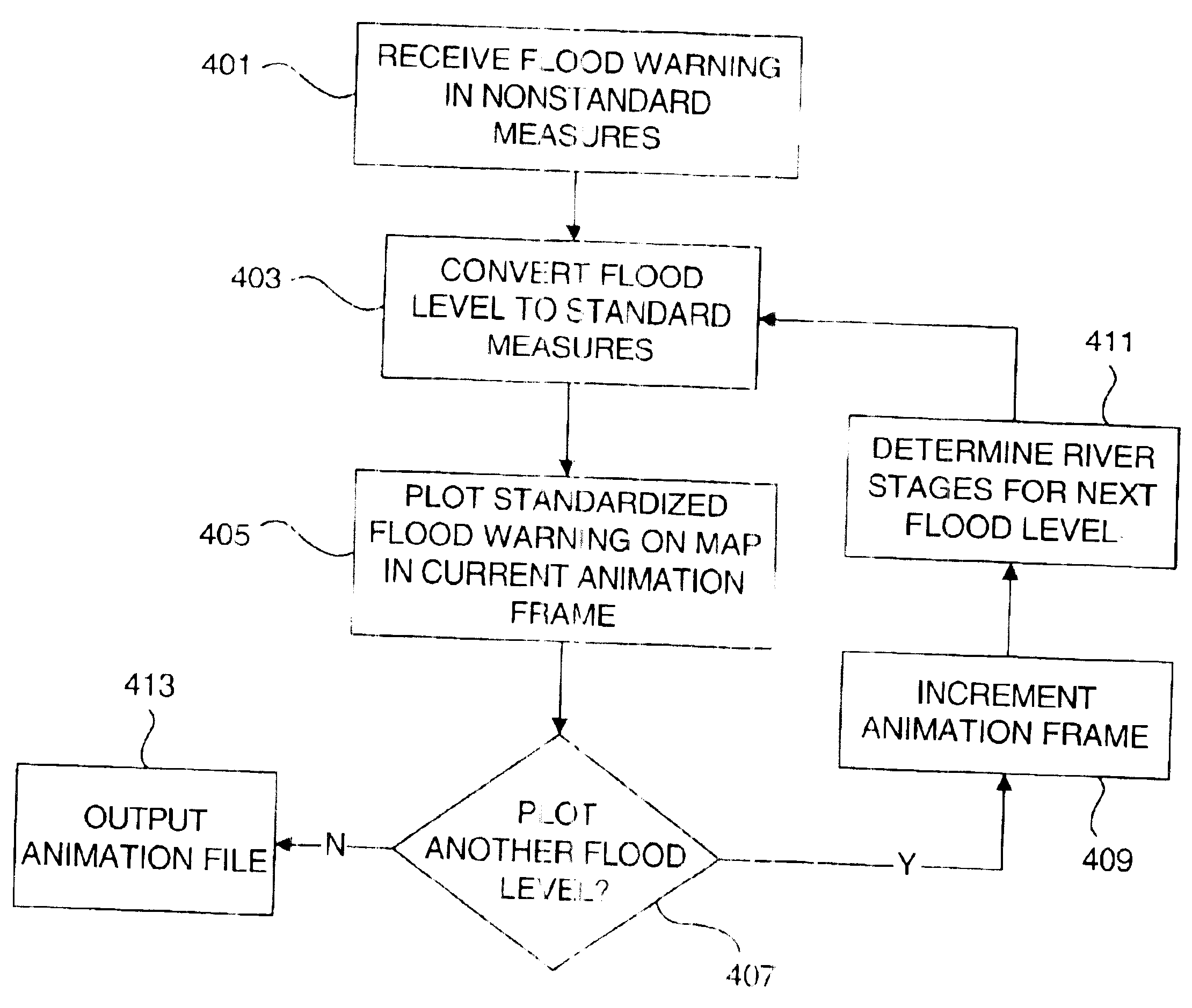
[0024]The present invention provides methods and systems for more accurately forecasting and predicting flood levels by converting flood levels based on localized river depth information to normalized values, thus allowing them to be plotted uniformly on geographical maps, which may in turn be used to create real-time inundation maps that provide clear, understandable flood warnings. While the invention is described with respect to potential flooding of a river and river gauges, the methods and systems described herein may be used to predict potential flooding stemming fr...


PUM


Abstract

Methods and systems for normalizing flood warnings and potential flood levels across multiple river gauges by converting localized flood stage levels to a datum-based normalized value are disclosed. The normalized flood levels can then be used to plot flood levels from multiple river gauges on an inundation map. Methods and systems are also disclosed for creating animated inundation maps that illustrate flood levels geographically, and may include an indication of the certainty that flooding will reach one or more of the indicated flood levels through the use of multiple colors, shades, dithering, or the like.

Description

FIELD OF THE INVENTION[0001]The invention relates generally to meteorology and hydrology. More specifically, the invention provides methods and systems for generating and animating hydrologic inundation maps for displaying normalized flood level information.BACKGROUND OF THE INVENTION[0002]Each year, floods are a major cause of economic loss and loss of life in the United States, causing millions of dollars in damages each year. In addition, floods cause much inconvenience to those affected by the flood due to cleanup, temporary or permanent relocation, etc. It should be possible to mitigate economic loss, inconvenience, and loss of life by more accurately predicting and conveying information regarding specific geographic areas that will be affected by flooding.[0003]Flood warnings provided by the National Weather Service (NWS) are presently not user-friendly. For example, an actual flood warning issued by the NWS for Wilmington, N.C. on Nov. 20, 2002 is shown in FIG. 1. The flood w...

Claims


Application Information

Patent Timeline
IPC IPC(8): G01W1/00G06F15/18G01W1/10
CPCG01W1/10G01K2203/00Y02A10/40
Inventor SMITH, MICHAEL R.LONG, MARK DAVID
Owner USER CENTRIC IP
Why Eureka
Try Eureka