System and method for geographically referencing an improvement image

a technology of system and method, applied in the field of system and method for geographical reference of improvement images, can solve the problems of insufficient geographical reference to facilitate correlation and/or combination with other available information, types of improvement images often lack sufficient specific geographic registration information, etc., to achieve reliable, accurate and automatic adaptation

Inactive Publication Date: 2006-02-21
HONEYWELL INT INC
View PDF9 Cites 143 Cited by
  • Summary
  • Abstract
  • Description
  • Claims
  • Application Information

AI Technical Summary

Benefits of technology

[0009]The instant invention provides for the addition of essential data to improvement images to facilitate reliable, accurate and automatic adaptation of the improvement image for combination with other geographically referenced images. This may comprise, for example, marking specific referen

Problems solved by technology

Unfortunately, however, the utility of this information is limited by the accuracy and extent to which features are depicted on a particular map or are otherwise commonly referenced.
Improvement images exist in a variety of scales and formats, but are often not sufficiently geographically referenced to facilitate their correlation and/or combination with other available information.
Thus, some types of improvement images often lack sufficient specific geographic registration information to enable them to be efficiently correlated, and/or manipulated for correlation, with relevant geographically referenced map images.
Further, although their use in conjunction with automated aircraft control systems offers great benefits, many ava

Method used


Image

  • System and method for geographically referencing an improvement image
  • System and method for geographically referencing an improvement image
  • System and method for geographically referencing an improvement image

Examples


Embodiment Construction

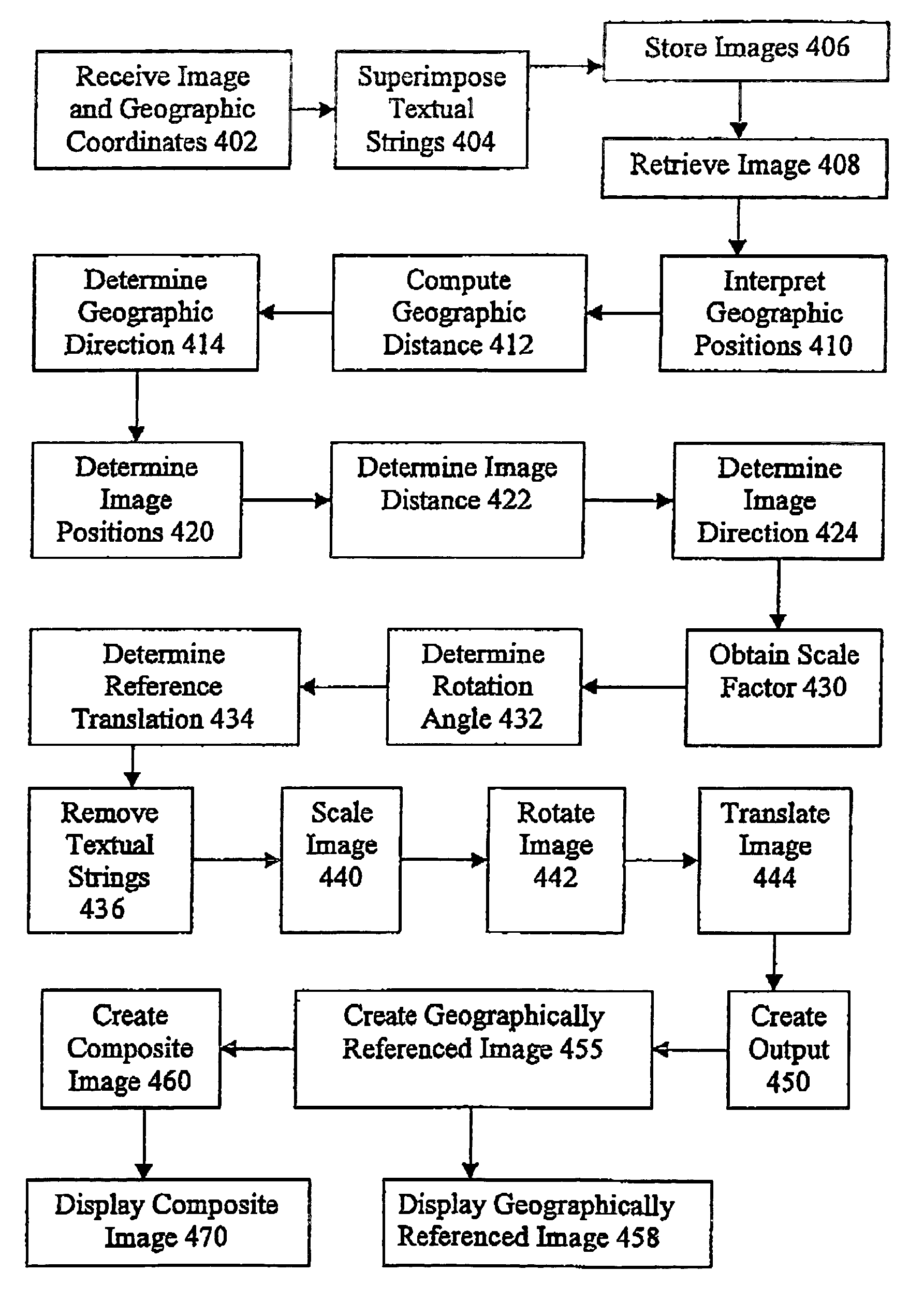
[0015]The instant invention provides a system and a process and / or method by which an improvement image, such as a computer line drawing, with embedded points marked with textual strings can be automatically scaled, rotated, and translated so that the improvement image may be geographically referenced and may be combined with other geographically referenced information to form a geographically referenced composite image.

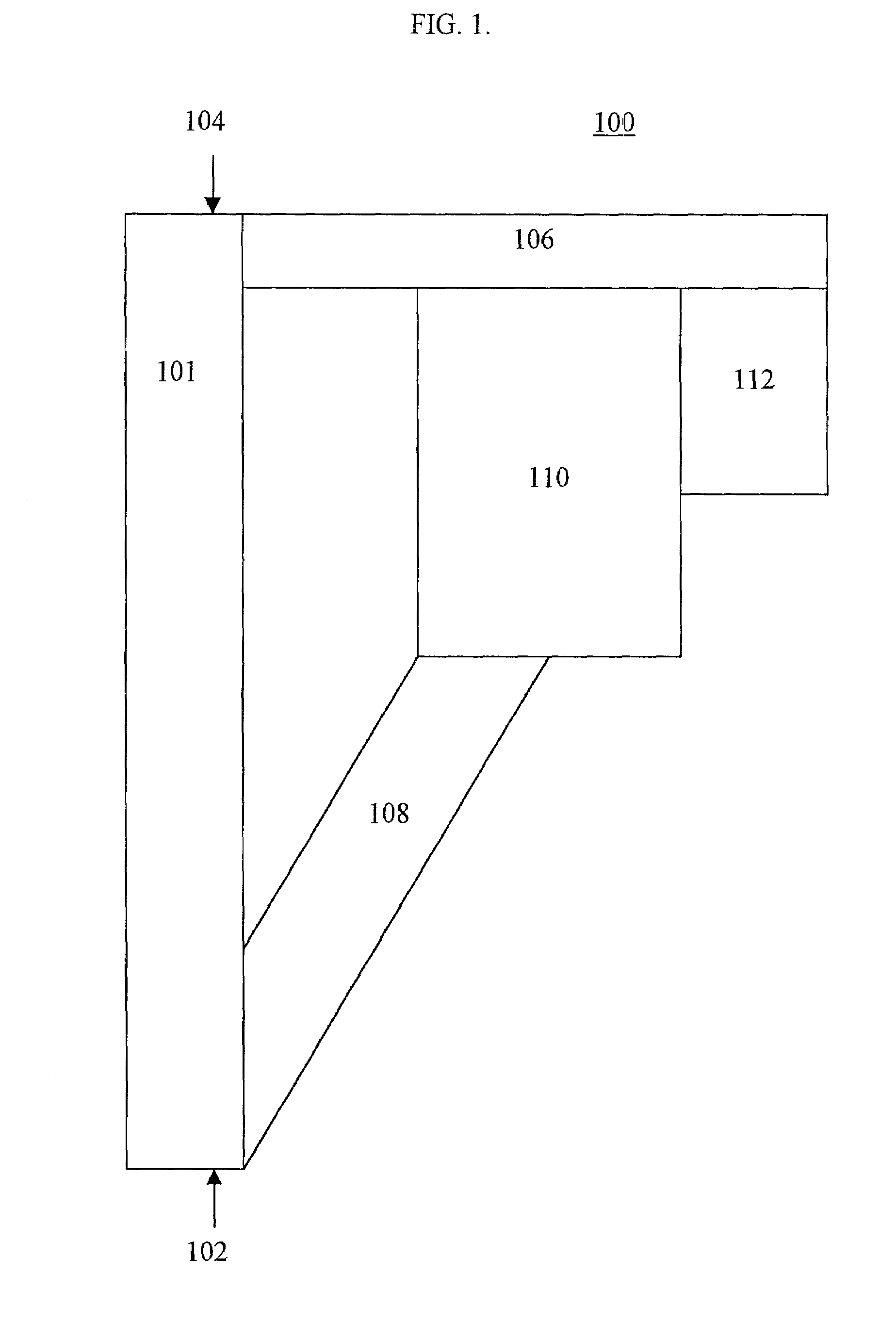
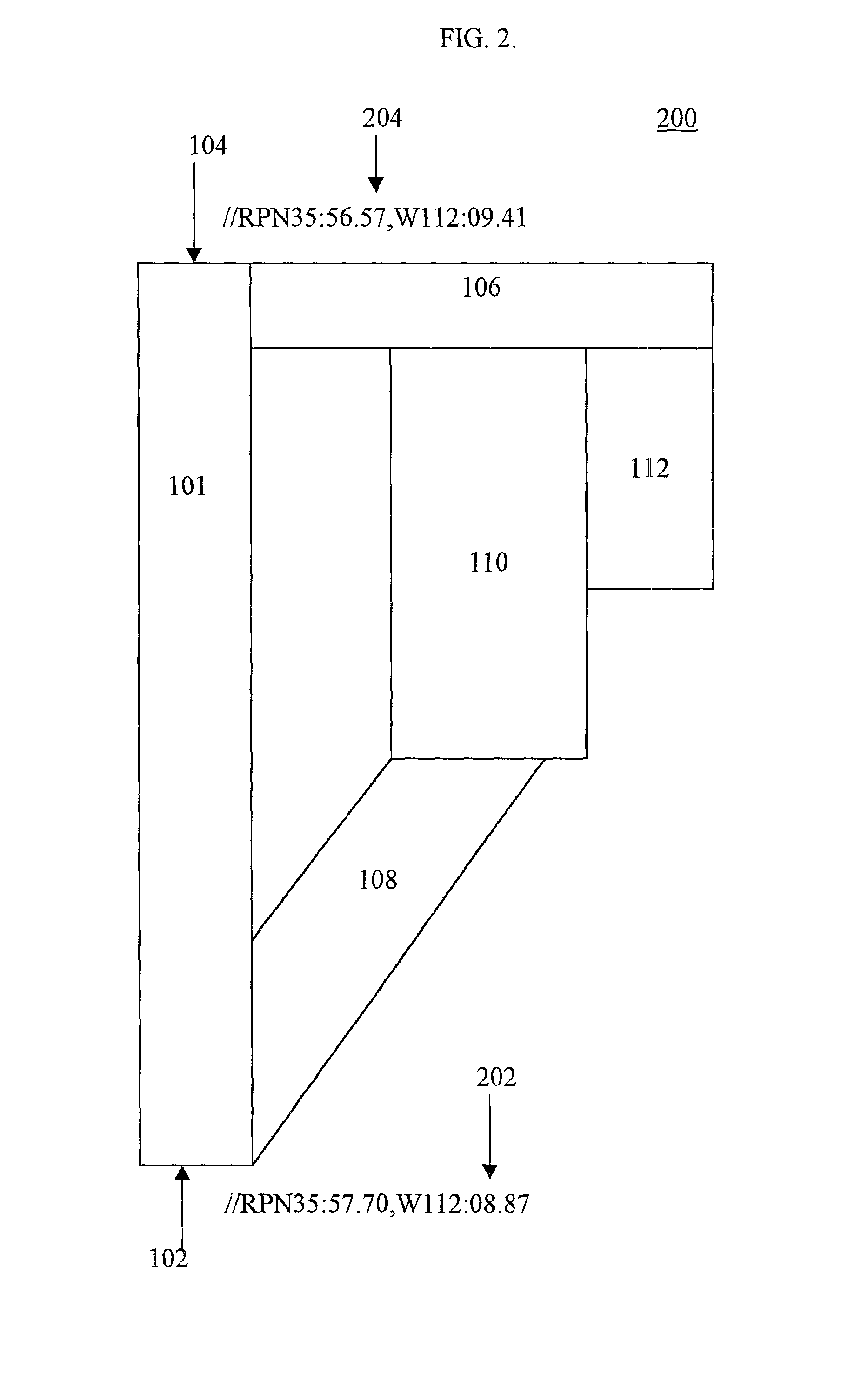
[0016]In accordance with an exemplary embodiment of the instant invention, FIG. 1 illustrates an improvement image 100 such as that which may be supplied to the system of the instant invention. In this case, improvement image 100 depicts elements of an airport including a runway 101 that has a beginning, depicted as first reference point 102, and an end, depicted as second reference point 104. Adjacent to runway 101 are taxiways 106, 108, parking area 110, and hanger area 112. Thus, in this case, improvement image 100 is a scale drawing of a plan view of the airport ...


PUM


Abstract

The instant invention is a system and method for converting improvement images to geographically referenced chart symbols and for combining improvement images with other geographically referenced information to create composite images. The instant invention provides for marking specific reference points on the improvement image with textual strings and using a system configured to recognize textual strings, to understand the information, and to determine the appropriate translation, rotation angle, and scale factor of the improvement image to render a geographically referenced image.

Description

BACKGROUND OF THE INVENTION[0001]In today's world, vehicles such as aircraft, and increasingly, automobiles, rely upon automated and semi-automated systems to aid in their dynamic control. Such systems often comprise means for determining vehicle static and / or dynamic information including vehicle position, velocity, acceleration, and orientation. These systems may use the acquired vehicle information to control the vehicle as it traverses its desired path and / or may communicate the information to a vehicle controller, which may include a driver or pilot or some other participant, to aid in the control of the vehicle.[0002]A variety of means are currently available for determining a vehicle's position relative to a known reference position, such as that of an orbiting satellite, or of a radar installation, or the like. Further, it should be noted that a vehicle's position, once determined, may be expressed as a translation from the reference position. In addition, the vehicle's posi...

Claims


Application Information

Patent Timeline
IPC IPC(8): G06K9/00G06K9/32G06K9/36G06T17/05G09B29/10
CPCG09B29/10G06T17/05
Inventor WILSON, BLAKE
Owner HONEYWELL INT INC
Why Eureka
Try Eureka