Dynamic navigation system

a dynamic navigation and display technology, applied in traffic control systems, navigation instruments, instruments, etc., can solve problems such as prone to inaccuracy of location providing devices

Inactive Publication Date: 2006-08-08
TAHOE RES LTD
View PDF25 Cites 260 Cited by
  • Summary
  • Abstract
  • Description
  • Claims
  • Application Information

AI Technical Summary

Benefits of technology

[0007]Embodiments of the present invention provide improved methods and systems for off-board mapping and navigation. These methods and systems permit rich, dynamic information to be downloaded rapidly and efficiently from a mapping server over a low-speed wireless link to a client device, typically a PDA or cellular telephone. Such wireless links are typically characterized by bandwidths below 10 kbps. Novel methods of data processing, on both the server and client sides of the interaction, enable the client to display maps to the user with enhanced speed and clarity, notwithstanding the limited communication bandwidth and display capabilities of the client device.
[0009]In another aspect of the invention, the mapping server determines a route comprising a sequence of route segments, from a starting point to a destination specified by the client. Typically, the starting point is the client's current position, while the destination is a selected map location or point of interest. While the user travels along the route, the server may receive dynamic information regarding a change in travel conditions in a vicinity of the route. The client device periodically submits requests to the server for updated information regarding the route. Each request specifies one or more of the route segments not yet traversed by the user based on the downloaded route and the location coordinates of the client device. In response to these requests, the server checks the dynamic information it has received and, if appropriate, downloads to the client a modified route to the destination, typically to avoid traffic jams and road blockages.
[0010]Additionally or alternatively, the server may receive other types of dynamic information regarding the area in which the client is traveling, and may convey the dynamic information to the client in real time. Preferably, the client shows the dynamic information on a map of the area that it has rendered, without having to re-render the map.
[0057]the server being further adapted to receive, while a user of the client device travels within the selected area, dynamic information with regard to the area, and to download the dynamic information to the client device, responsively to the location coordinates of the client device, causing the client device to display the dynamic information on the image of the selected area of the map displayed by the client device, without requiring the client device to render the image of the selected area again.
[0064]the instructions further causing the computer to receive dynamic information with regard to the area and location coordinates of the client device, while a user of the client device travels within the selected area, and to download the dynamic information to the client device, responsively to the location coordinates, causing the client device to display the dynamic information on the image of the selected area of the map displayed by the client device, without requiring the client device to render the image of the selected area again.

Problems solved by technology

Such location providing devices, however, are prone to inaccuracy.

Method used


Image

  • Dynamic navigation system
  • Dynamic navigation system
  • Dynamic navigation system

Examples


Embodiment Construction

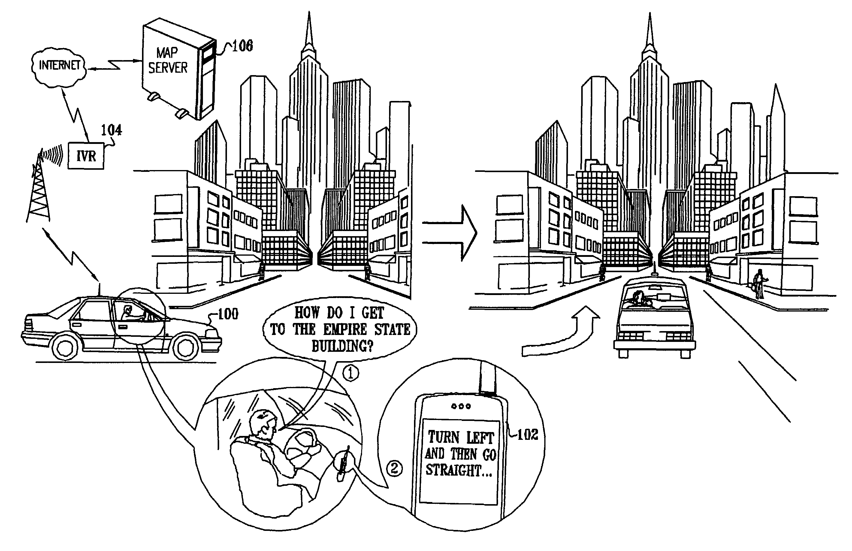
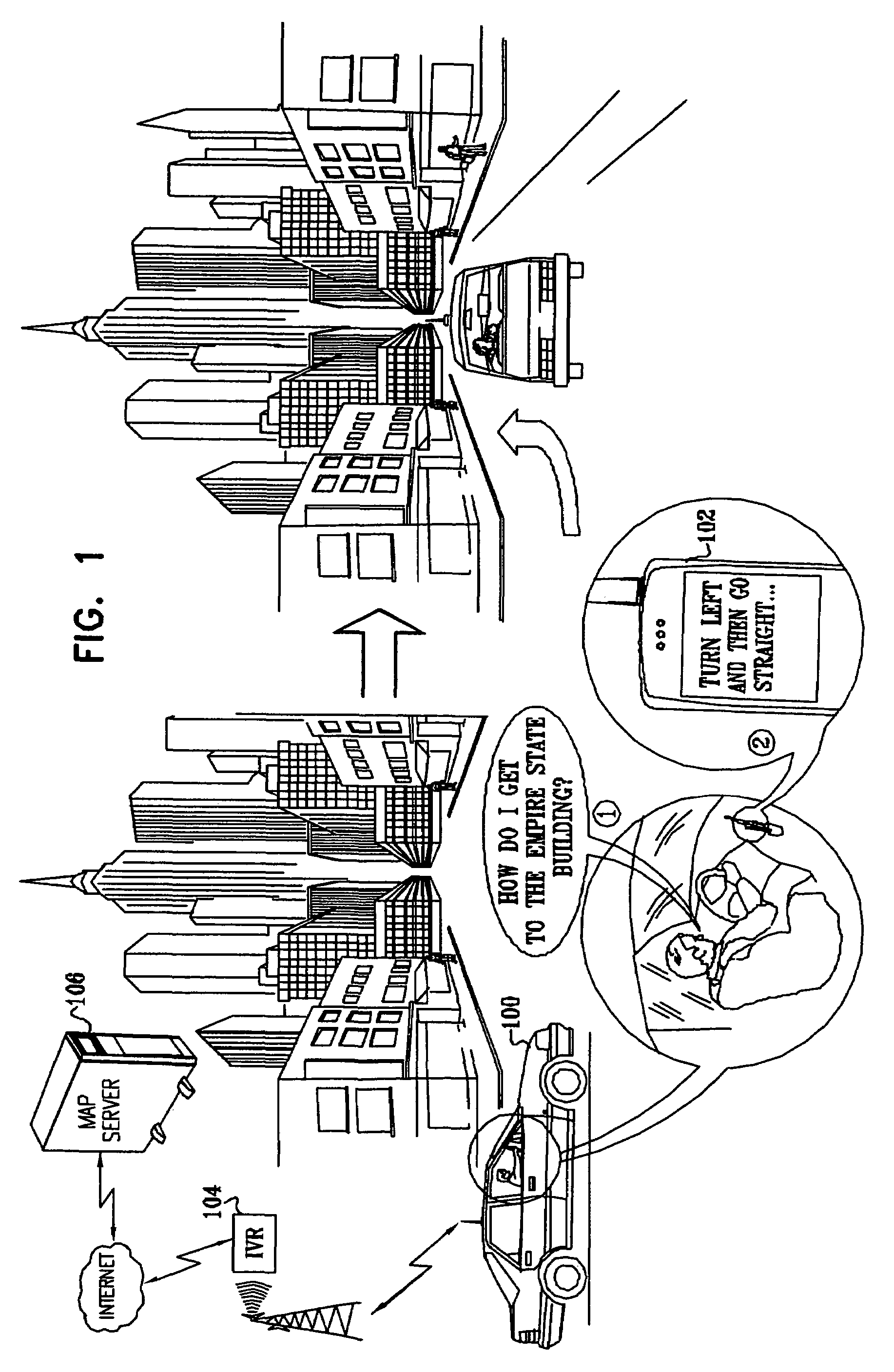
[0090]Reference is now made to FIG. 1, which is a simplified pictorial illustration of a real-time map distribution and display system constructed and operative in accordance with an embodiment of the present invention. As seen in FIG. 1, a driver of a vehicle 100 communicates via a wireless communicator, such as a conventional cellular telephone 102, with a interactive voice response (IVR) processor 104 and through IVR 104 via the Internet with a map server 106.

[0091]In the illustration, the driver asks directions to the Empire State Building. In real time, preferably within four seconds or less, while driving, the driver receives the requested directions. More preferably, the directions are provided within two seconds, and most preferably, the directions are provided substantially immediately, i.e., within one second. In the illustration, the directions are requested by the driver and provided to the driver orally, typically using speech recognition and speech synthesis tools, as ...


PUM


Abstract

A method for navigation includes storing map data on a server, the map data including vector information delineating roads in a map. A portion of the vector information corresponding to an area in which a user of a mobile client device is traveling is downloaded from the server to the client device. Approximate position coordinates of the user are found using a location providing device associated with the client device and are corrected in the client device, using the downloaded vector information, so as to determine a location of the user on one of the roads in the map. A navigation aid is provided to the user of the client device based on the determined location.

Description

CROSS-REFERENCE TO RELATED APPLICATION[0001]This is a continuation of application Ser. No. 10 / 426,947 filed on Apr. 30. 2003 now U.S. Pat. No. 6,917,878. This application claims the benefit of U.S. Provisional Patent Application 60 / 377,019, filed Apr. 30, 2002. This application is also related to two other patent applications, filed on even date, which are entitled “Template-Based Map Distribution System” and “Navigation System Using Corridor Maps”. The disclosure of all these related applications are incorporated herein by reference.FIELD OF THE INVENTION[0002]The present invention relates to data distribution and display systems and methodologies and more particularly to map data display systems and methodologies.BACKGROUND OF THE INVENTION[0003]A variety of systems are known in the art for providing drivers with in-vehicle electronic routing maps and navigation aids. These systems are commonly coupled to a location-finding device in the vehicle, such as a Global Positioning Syste...

Claims


Application Information

Patent Timeline
Patent Type & Authority Patents(United States)
IPC IPC(8): G01C21/26G01C21/32G01C21/30G01C21/36
CPCG01C21/26G01C21/30G01C21/32G01C21/3682G01C21/3611G01C21/3667G01C21/3679G01C21/36G01C21/3889
Inventor PECHATNIKOV, MICHAELKUPFERMAN, MICHAEL MENACHEMYADAN, OMRYECKSTEIN, ILYAFAGIN, ALEXANDERNISSIM, OREN
Owner TAHOE RES LTD
Why Eureka
Try Eureka