Method and system for forming, updating, and using a geographic database

a technology of geographic database and method, applied in the field of method and system for forming, updating, and using a geographic database, can solve the problem of out-of-date geographic data used by the navigation system

Active Publication Date: 2006-08-29
HERE GLOBAL BV
View PDF31 Cites 67 Cited by
  • Summary
  • Abstract
  • Description
  • Claims
  • Application Information

AI Technical Summary

Benefits of technology

[0008]To address these and other objectives, the present invention includes a method for merging of multiple databases that may be stored on different media. According to an embodiment, a baseline template geographic database is formed. The baseline template geographic database is organized into spatial parcels. This organization is referred to as the baseline parcelization pattern. Each spatial parcel is assigned a unique ID based on its position in a binary tree index that corresponds to the location of the geographic area that contains the features represented by the data contained in the parcel. Multiple partial databases, each comprised entirely of whole parcels, can be extracted from the baseline template geographic database and used independently. Because the parcels in these partial databases are consistent, i.e., they correspond to the same baseline parcelization pattern, one or more partial databases can be merged into a

Problems solved by technology

One consideration associated with navigation systems is that ge

Method used


Image

  • Method and system for forming, updating, and using a geographic database
  • Method and system for forming, updating, and using a geographic database
  • Method and system for forming, updating, and using a geographic database

Examples


Embodiment Construction

I. Overview of Database Formation, Updating and Distribution Processes.

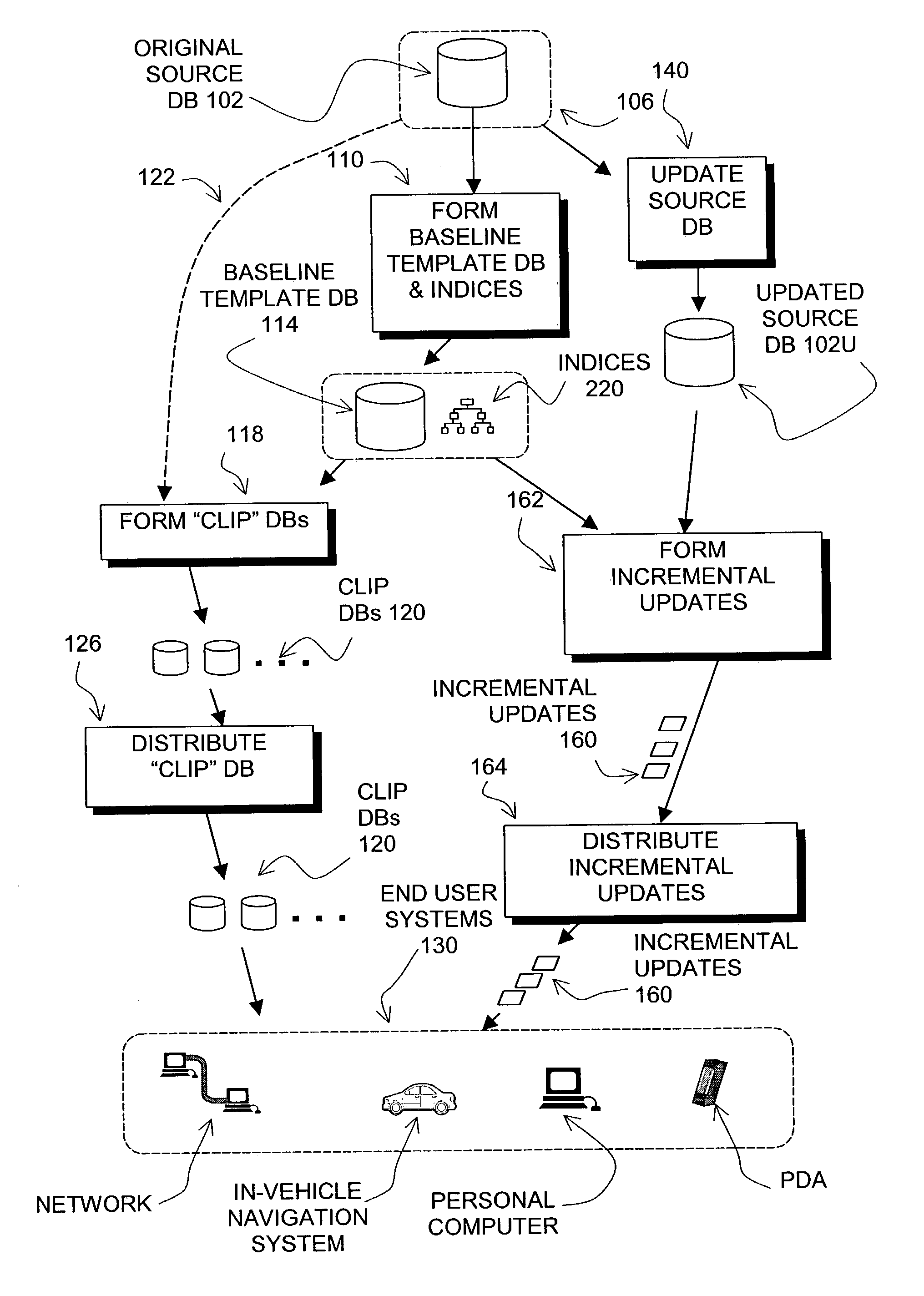
[0021]FIG. 1 illustrates processes for forming, distributing and updating geographic databases used in end users' navigation systems. In FIG. 1, a source version 102 of a geographic database contains data that represent geographic features in a coverage region. The coverage region may correspond to an entire continent, such as North America or Europe. Alternatively, the coverage region may correspond to a single country, such as the United States, or several countries, such as the United States and Canada, or France, Germany, and Italy, and so on. According to another alternative, the coverage region may correspond to only a portion of a country, such as the West Coast or the Midwest of the U.S. Although the source version 102 of the geographic database includes data that represent geographic features in the entire coverage region, there may be parts of the coverage region that contain geographic features that ar...


PUM


Abstract

A method and system are disclosed for the merging of multiple map databases. These multiple map databases can be stored on separate media. Each map database is comprised of whole parcels and conforms to a baseline parcelization pattern. At run time in a navigation system, a single parcel index is constructed that contains references to parcels from the multiple map databases. References to parcels use a combined media directory covering all media objects. The combined media directory is created by merging tables of contents from each media object. This method can be used to incrementally update a geographic database.

Description

BACKGROUND OF THE INVENTION[0001]The present invention relates to systems and methods for forming, updating and using databases that contain geographic data that are used in computing platforms, such as navigation systems, that provide navigation-related features or services.[0002]Navigation-related functions are provided on various different computer platforms. For example, navigation-related functions can be provided from standalone systems or networked systems. In a standalone navigation system, the software applications, geographic data, and hardware are combined at a single location. A standalone system may be installed in a vehicle or carried by a person. In a networked navigation system, some of the software or geographic data are located with the hardware with the user and some of the software or geographic data are located remotely and accessed over a communications system. Navigation-related functions are provided by systems implemented on dedicated platforms in which the ...

Claims


Application Information

Patent Timeline
IPC IPC(8): G06F7/00G01C21/26G01C21/30G08G1/123G09B29/00G06F17/30G06T11/60G06T17/05
CPCG06F17/30241G01C21/32G06F16/29G01C21/3893G01C21/3889G01C21/3874G01C21/3881G01C21/3878
Inventor MCDONOUGH, WILLIAM
Owner HERE GLOBAL BV
Why Eureka
Try Eureka