Adaptive navigation system with artificial intelligence

a navigation system and artificial intelligence technology, applied in the field of vehicle navigation systems, can solve the problems of limiting the functionality of navigation radios, user to pay significant fees to update the fixed map database, and the algorithm of the navigation system does not take into account driver habits

Inactive Publication Date: 2005-05-12
HARMAN INT IND INC
View PDF10 Cites 306 Cited by
  • Summary
  • Abstract
  • Description
  • Claims
  • Application Information

AI Technical Summary

Benefits of technology

[0012] The vehicle navigation system may include a navigation control unit that may be connected with a display, a user input device, a digital map database, a positioning system, a storage device and a traffic event notification device. The display may be used to generate a graphical representation of a road network map included in the digital map database that m

Problems solved by technology

Navigation system algorithms do not take into account driver habits, mistakes in the database and new roads that are constructed after the map data in the database was released into fixed media.
As such, this limits the functionality of the naviga

Method used


Image

  • Adaptive navigation system with artificial intelligence
  • Adaptive navigation system with artificial intelligence
  • Adaptive navigation system with artificial intelligence

Examples


Embodiment Construction

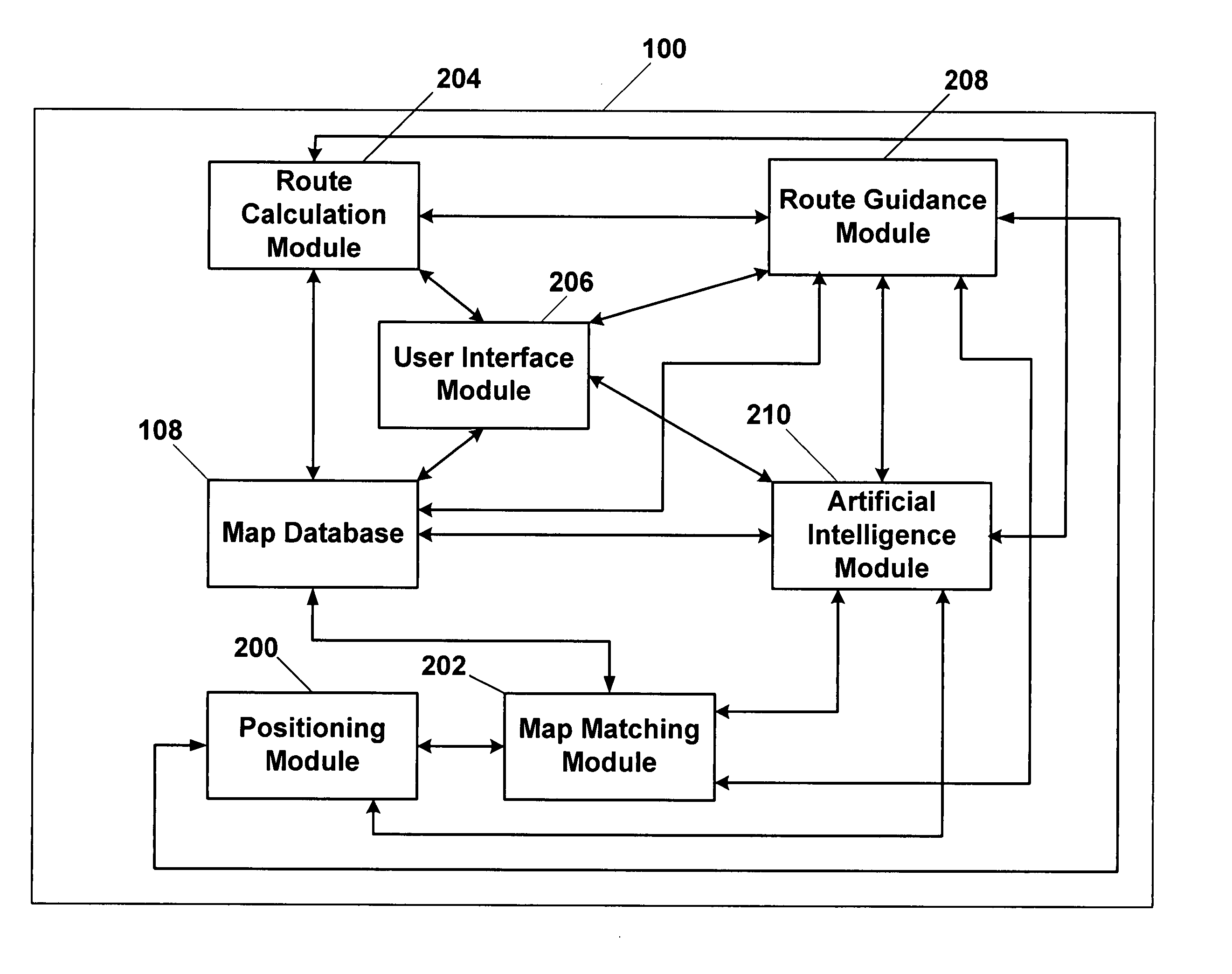
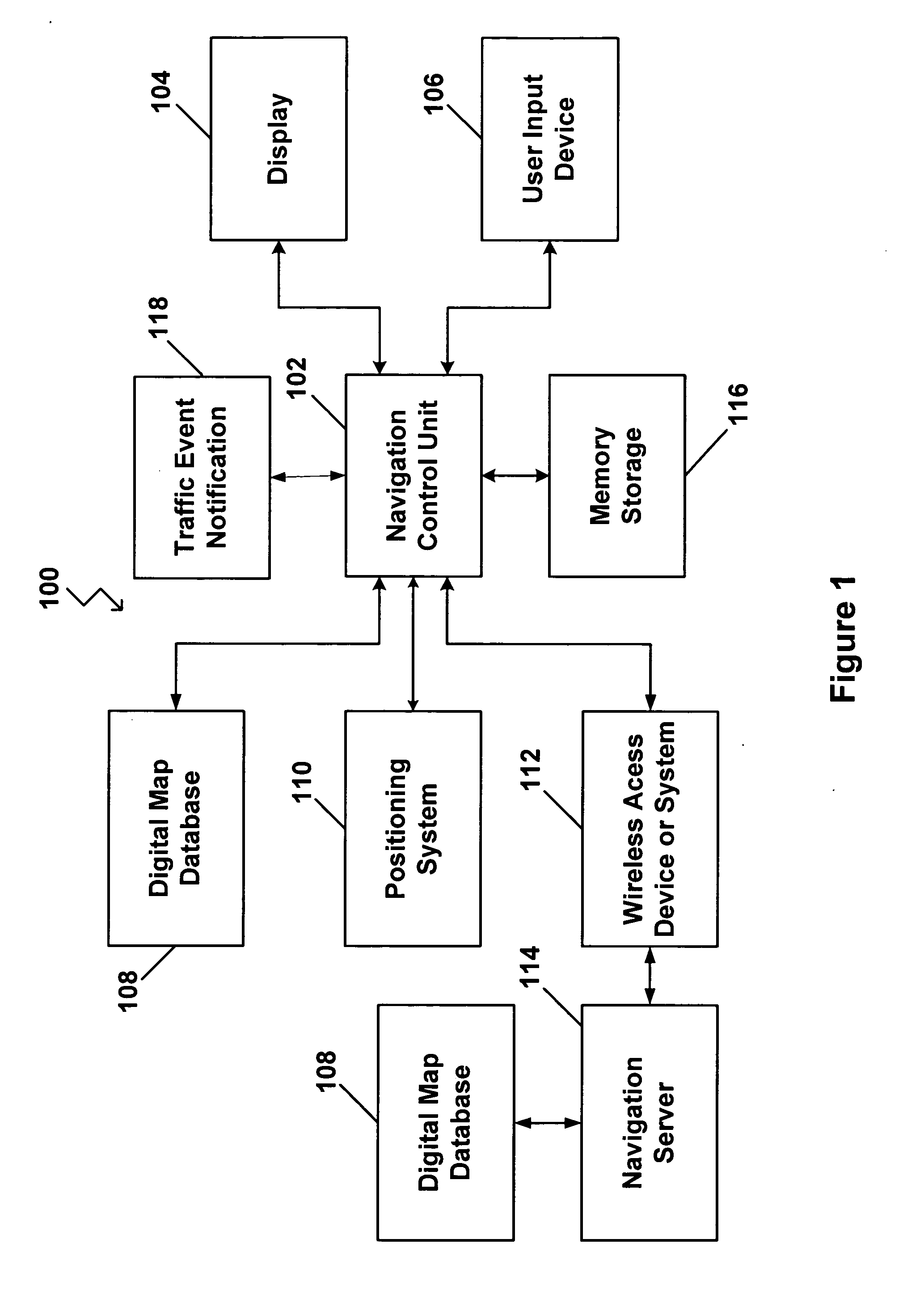
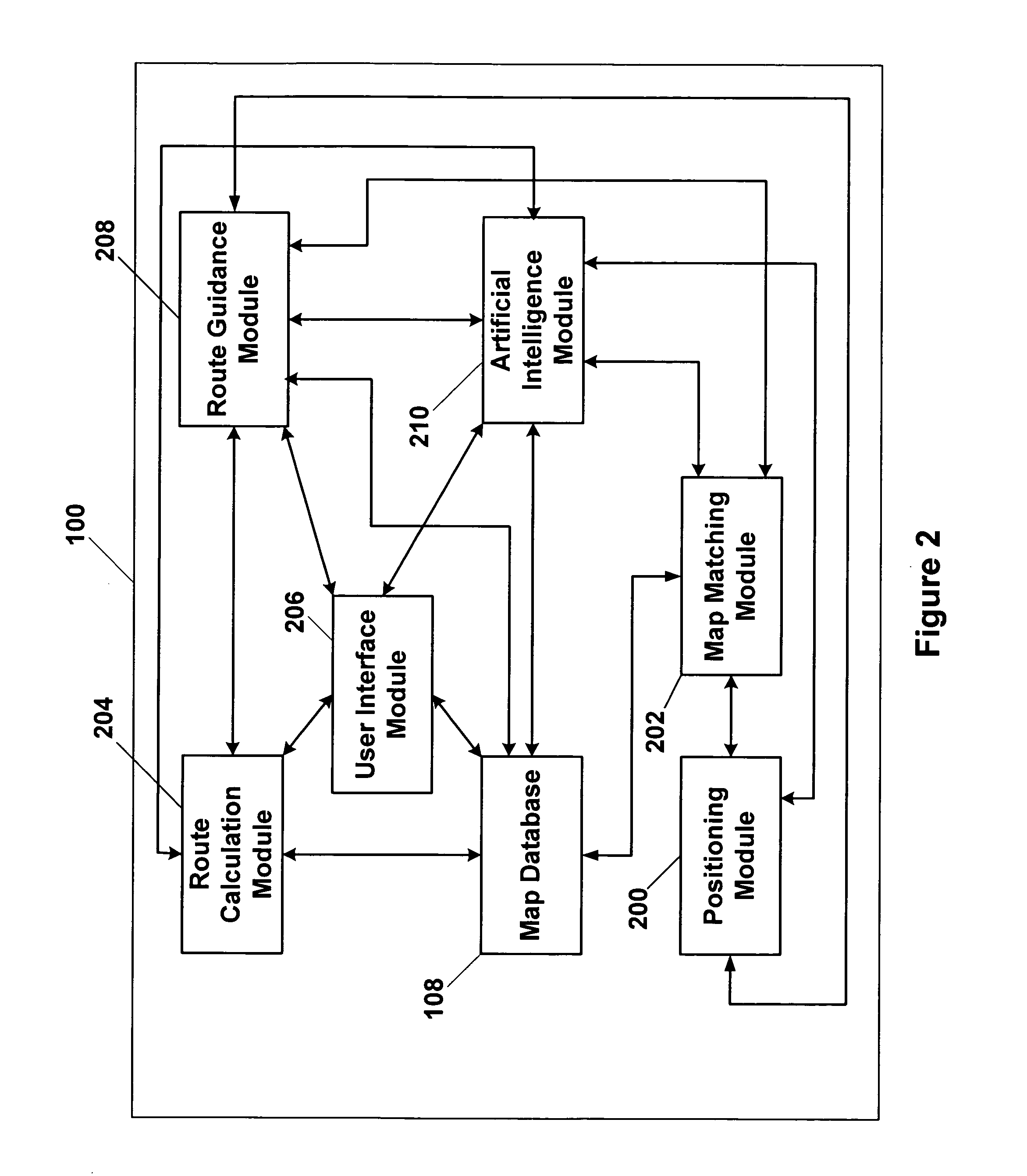
[0022] In FIG. 1, a navigation system 100 with artificial intelligence that is capable of learning driver habits and preferences, mistakes in map databases and new roads is depicted. As illustrated, the navigation system 100 includes a navigation control unit 102 that processes software modules and components that are programmed to calculate routes from points of origin to destinations as well as provide various other types of data to a driver. Although not specifically illustrated, the navigation control unit 102 may include a Central Processing Unit (“CPU”), a system bus, a Random Access Memory (“RAM”), a Read Only Memory (“ROM”), an I / O adapter for connecting peripheral devices such as hard disc drives, CD drives, a communications adapter, and a display adapter. Various computing devices and components may be used to provide the functionality performed by the navigation control unit 102.

[0023] The navigation control unit 102 may be connected with a display 104. In one example, t...


PUM


Abstract

A vehicle navigation system that is capable of learning user habits/preferences, mistakes in a digital map database, and new roads that may have been added or constructed after release of the digital map database is disclosed. The vehicle navigation system monitors a driver's habits and updates a database to thereby cause the vehicle navigation system to have a preference for the driver's habits. The vehicle navigation system may also monitor the geographic position of the vehicle and allow the driver to update or change data contained in the digital map database if an error exists. The vehicle navigation system is also capable of learning new roads that exist that are not included in the road network map of the digital map database and is also capable of adding these new roads to the digital map database.

Description

BACKGROUND OF THE INVENTION [0001] 1. Technical Field [0002] This invention relates generally to vehicle navigation systems and, more particularly, to an adaptive navigation system that is capable of taking into account and learning driver habits, mistakes in the digital map database and new roads that are constructed after the digital map database has been released. [0003] 2. Related Art [0004] Vehicle navigation systems are becoming increasingly popular in the automobile industry. A typical vehicle navigation system may include a global positioning system (“GPS”) receiver that may be mounted somewhere on the vehicle. The GPS receiver is capable of communicating with a satellite-based global positioning system or other localized positioning systems. The GPS receiver obtains geographic position information that may be converted into some form of display for the vehicle operator indicating the position of the vehicle relative to previously determined reference points or other known l...

Claims


Application Information

Patent Timeline
IPC IPC(8): G01C21/34
CPCG01C21/3484G01C21/32G01C21/3844G01C21/3815G01C21/3837
Inventor MONTEALEGRE, STEVE E.HAMMER, KARLDISSOSWAY, MARC A.
Owner HARMAN INT IND INC
Why Eureka
Try Eureka