Method and apparatus for displaying a map

a map and display technology, applied in the field of methods and apparatus for displaying maps, can solve the problems of map visibility, map detail cannot be recognized in more detail, map detail degradation or other problems

Inactive Publication Date: 2007-07-03
ALPINE ELECTRONICS INC
View PDF3 Cites 21 Cited by
  • Summary
  • Abstract
  • Description
  • Claims
  • Application Information

AI Technical Summary

Benefits of technology

[0008]Accordingly, it is an object of the invention to allow display of a map covering the vicinity of a present position as widely as possible so that the user can recognize a relationship with the present position.

Problems solved by technology

This, however, results in degradation of the degrees of detail of the map or of visibility thereof, so that the map cannot be recognized in more detail.

Method used


Image

  • Method and apparatus for displaying a map
  • Method and apparatus for displaying a map
  • Method and apparatus for displaying a map

Examples


Embodiment Construction

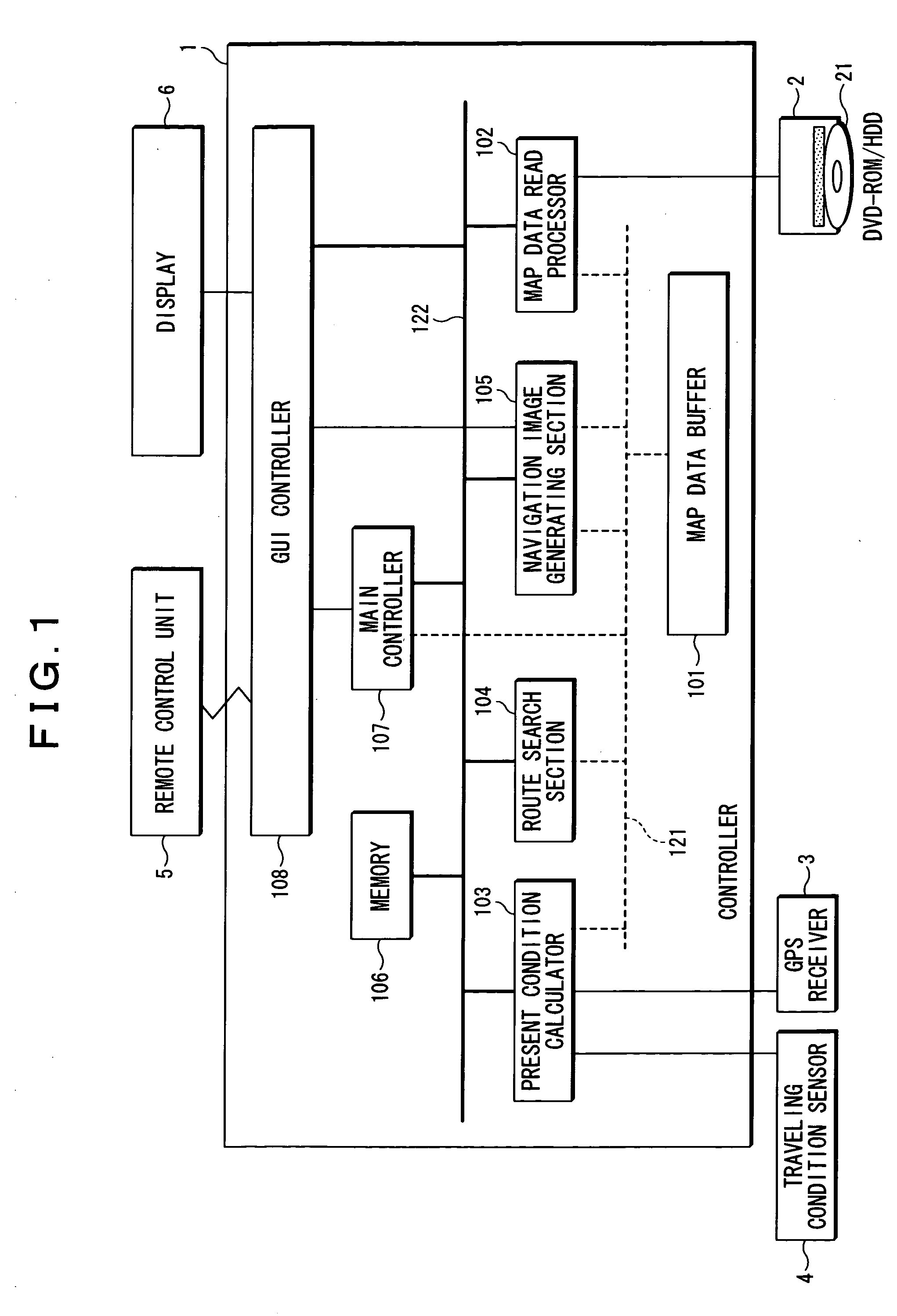
[0039]FIG. 1 illustrates a configuration of a navigation apparatus according to an embodiment of the present invention.

[0040]As shown in FIG. 1, the present navigation apparatus includes a controller 1, a recording medium drive 2 for accessing a recording medium 21, such as a DVD-ROM, a hard disk, or the like, which stores map data therein, a GPS receiver 3, a traveling condition sensor 4 for detecting a traveling condition of a vehicle, such as an angular acceleration sensor, a vehicle speed sensor, or the like, a remote control unit (remote controller) 5 for accepting input from the user, and a display 6.

[0041]The controller 1 includes a map data buffer 101, a map data reading processor 102, a present condition calculator 103, a route search section 104, a navigation image generating section 105, a memory 106, a main controller 107, and a GUI controller 108. In FIG. 1, dotted lines 121 inside the controller 1 each represent an access route from each section to the map data stored ...


PUM


Abstract

A navigation apparatus and method of displaying a map are provided for scrolling and displaying the map covering the vicinity of a present position such that a relationship with the present position can be constantly recognized.When a request for a surrounding scroll starting operation is accepted from a user, a display range is moved upward until the present position is located in the center of a lower hem of the display range of the map, that is, until an upper half of a present position mark is positioned in the center of a bottom of the display range. Then, the display range is moved in stages, i.e. in such a manner that the present position is moved to a lower left edge thereof, to an upper left edge thereof, to an upper right edge thereof, and to a lower right edge thereof, in this order. Thereafter, the display range is gradually moved rightward until the present position is located in the center of the lower hem of the display range. Finally, the display range is gradually moved downward until the present position returns to the original position located before starting the first surrounding scroll process.

Description

BACKGROUND OF THE INVENTION[0001]1. Field of the Invention[0002]The present invention relates to the display of maps and information about a present position on the map on a navigation apparatus.[0003]2. Description of the Related Art[0004]A navigation apparatus mounted on a vehicle may be used to guide a user in traveling from one location to another. A display may be used to present a map of an area and a mark indicating the present position of the vehicle. The navigation apparatus may also include guidance technology that allows a user to set a designation and will in turn set a guidance route to the accepted destination, and guide the user along the set guidance route.[0005]Other technology, known as altering (or scrolling), may also be used in displaying a map in a navigation apparatus. Various user operations, such as moving the cursor, or scrolling the map, or the like, may use altering. As disclosed in Japanese Patent Laid-Open Nos. 2000-292194 and 2002-81942 Publications, a...

Claims


Application Information

Patent Timeline
Patent Type & Authority Patents(United States)
IPC IPC(8): G01C21/30G09B29/00G01C21/00G01C21/32G01C21/36G08G1/0969G09B29/10
CPCG01C21/367G09B29/106
Inventor TAKIZAWA, AKIHIKO
Owner ALPINE ELECTRONICS INC
Why Eureka
Try Eureka