Determining precise direction and distance to a satellite radio beacon

a satellite radio beacon and precise direction technology, applied in direction finders, instruments, measurement devices, etc., can solve problems such as inaccurate direction and especially distance measurements, information might not be updated, and determine the direction and distance to such a homing signal

Active Publication Date: 2009-07-21
MOBIT TELECOM
View PDF3 Cites 13 Cited by
  • Summary
  • Abstract
  • Description
  • Claims
  • Application Information

AI Technical Summary

Problems solved by technology

However, this information might not be updated due to communication problems from beacon to satellites or from shore stations to SAR team.
However, determining direction and distance to such a homing signal has several drawbacks: a) direction and especially distance measurements are inaccurate; b) measurement is mostly sensitive to movements of the measuring device, almost impossible when done from a highly dynamic platform such as a vessel on high seas; c) operation range is limited due to the low transmission power of the homing signal; d) if a single 406 MHz antenna is used for the radio beacon, the homing RF signal might miss-match that antenna; e) a homing transmitter adds cost and weight and power consumption.
Still, other drawbacks of the current homing technique are not repaired.
This method can be effective for very basic radio beacons and short distances, yet it obtains several drawbacks: direction measurement is done by manually pointing a device towards the radio beacon thus sensitive to movements and inaccurate; distance measurement requires advancing towards the beacon and is not accurate until significantly close to the radio beacon.
As such, it does not address specific issues related to satellite radio beacons.
For example, in the Cospas-Sarsat system the entire 406-406.1 MHz band is divided into multiple narrowband discrete channels thus challenging a compatible receiver that should detect radio beacons transmitting spontaneously on different frequencies.
It does not address satellite radio beacons which usually cannot be interrogated (since obtain an RF transmitter and no RF receiver), neither deals with other satellite radio beacon receiving issues such as the multiple Cospas-Sarsat channels.
Unfortunately, the standard 406 MHz radio beacon signal cannot be detected by standard aircraft receivers and it is neither on the maritime VHF band.
Also, it is difficult to be tracked by regular DF devices since it is transmitted in bursts, about 0.5 seconds every 50 seconds.
Practically, some frequencies in this band cannot be supported by the satellites' payloads; also Cospas-Sarsat regulates these channels according to capacity and load.
Thousands of persons are lost at sea every year due to MOB accidents.
However, in many cases, especially when MOB occurs far away offshore, the most and perhaps only reliable SAR can arrive from the very vessel from which MOB occurred.
The present art methods described above have not yet provided satisfactory solutions to the problem of precisely determining the direction and distance to a satellite radio beacon.

Method used


Image

  • Determining precise direction and distance to a satellite radio beacon
  • Determining precise direction and distance to a satellite radio beacon
  • Determining precise direction and distance to a satellite radio beacon

Examples


Embodiment Construction

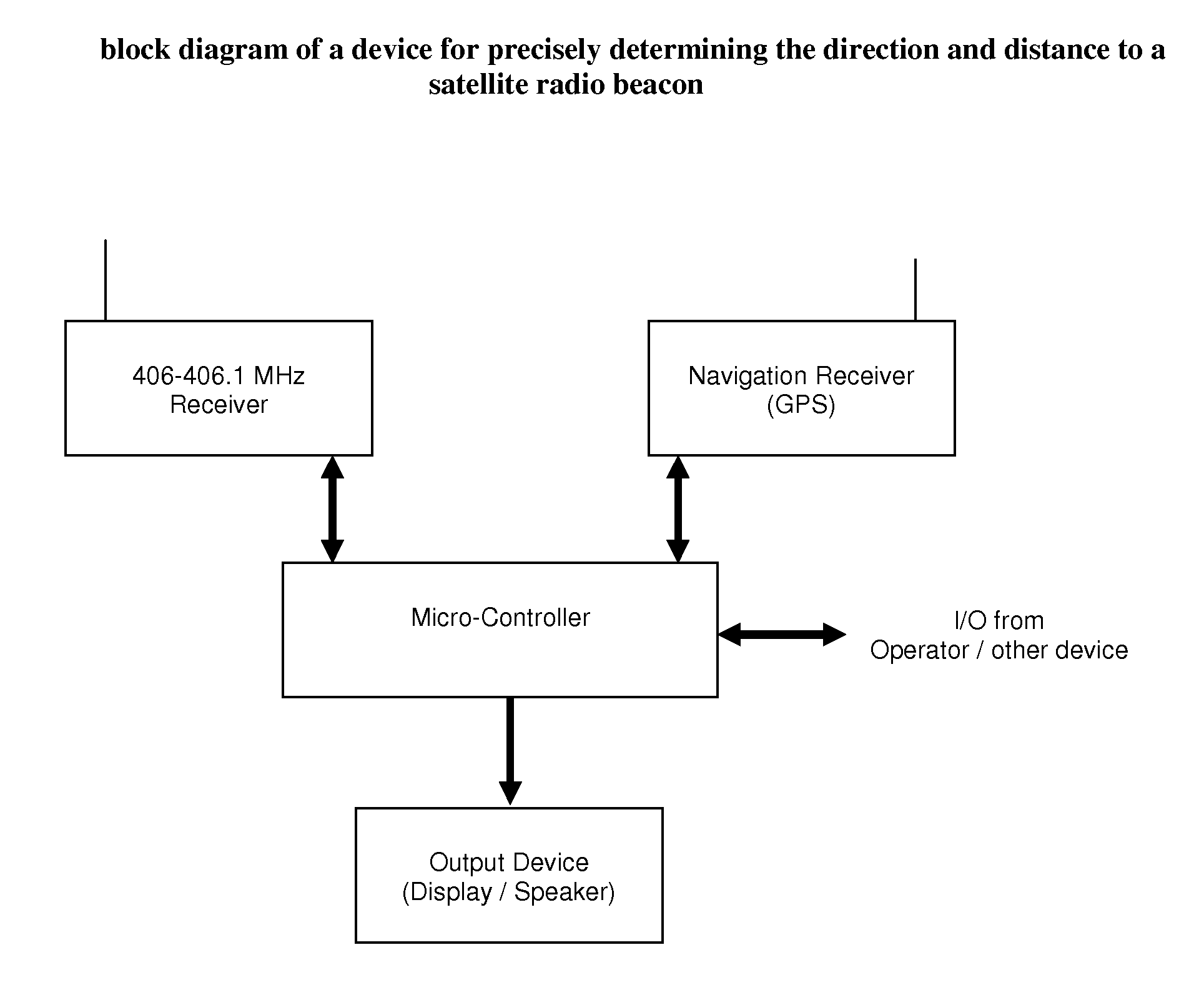
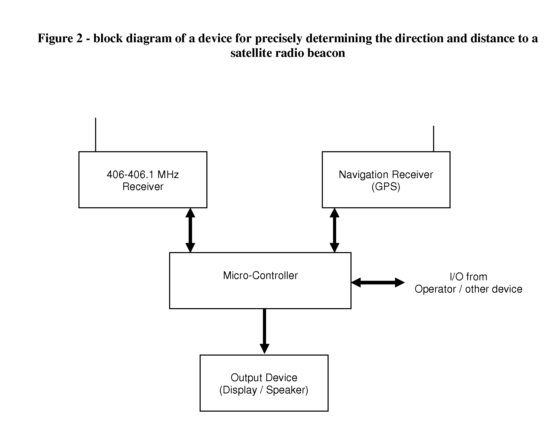
[0070]The present invention discloses a device and method for precisely determining the direction and distance to a satellite radio beacon, comprised of:

[0071]a) A first receiver configured to receive radio beacon signals;

[0072]b) A second receiver configured to receive navigation signals from a positioning system;

[0073]c) A microcontroller;

[0074]d) An output device;

[0075]whereby said device is configured to scan preset radio channels, detect a signal transmitted by a radio beacon to satellites on one of said channels, decode the message modulated in said signal indicating said radio beacon's position, determine self position by means of said navigation receiver, calculate the direction and distance from said device to said radio beacon by means of said microcontroller and indicate said direction and distance on said output device.

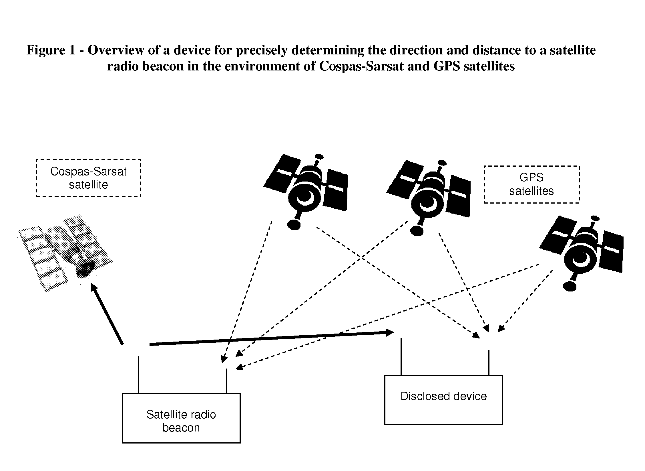
[0076]FIG. 1 is an overview of a device for precisely determining the direction and distance to a satellite radio beacon, in the environment of Cospas-Sar...


PUM


Abstract

The present invention discloses a device and method for precisely determining the direction and distance to a satellite radio beacon. In one embodiment, the disclosed device is used for SAR (search and rescue) of people in distress, upon activation of an emergency radio beacon, such as a marine EPIRB (Emergency Position Indicating Radio Beacon) or an airborne ELT (Emergency Locator Transmitter) or a terrestrial PLB (Personal Location Beacon) or a marine SSAS (Ship Security Alert System) beacon, beacons which are part of the Cospas-Sarsat system.

Description

BACKGROUND OF THE INVENTION[0001]Emergency radio beacons, especially those detectable by satellites, can be instrumental for search and rescue of people in distances, anywhere and anytime.[0002]The use of satellites to detect and locate special-purpose radio beacons either manually activated or automatically activated upon aircraft crash or ship wreck, reduces the time required to alert the appropriate authorities and to accurately locate the distress site by the rescue team. The International Maritime Organization (IMO) and the International Civil Aviation Organization (ICAO) recommend that ships and aircraft carry Emergency Position Indicating Radio Beacons (EPIRBs) and Emergency Locator Transmitters (ELTs) respectively. Recently, small size Personal Locator Beacons (PLBs) are getting more and more popular for terrestrial use, by hikers, skiers, hunters, travelers, etc', as well as mariners and seafarers that might be in danger of Man Over Board (MOB) or other marine dangers.[0003...

Claims


Application Information

Patent Timeline
Patent Type & Authority Patents(United States)
IPC IPC(8): G01S1/08G01S5/14G01S19/48
CPCG01S5/0231G01S19/48G01S19/51
Inventor KATZ
Owner MOBIT TELECOM
Why Eureka
Try Eureka