Method and system for spatial behavior modification based on geospatial modeling

a geospatial modeling and behavior modification technology, applied in the field of spatial modeling, can solve the problems of limited past systems and inability to simultaneously allow rapid assessment determinations with increased accuracy, and achieve the effect of rapid and more accurate assessment determinations

Active Publication Date: 2010-09-21
MAXAR MISSION SOLUTIONS INC
View PDF18 Cites 26 Cited by
  • Summary
  • Abstract
  • Description
  • Claims
  • Application Information

AI Technical Summary

Benefits of technology

[0008]The present invention assists in forecasting occurrences of identifiable events and / or results based on signature and / or pattern matching. In one embodiment, the present invention identifies and indexes functional measurements for one or more “cells” within a boundary or geographical area of interest, derives a signature pattern for event types of interest, and then links the derived signature to the stored cell information to assess the likely area for a future event of the same or similar event-type occurring. The present invention provides highly refined modeling processes to assist in quickly focusing on the proper measurement type and / or variable type, and detailing analysis around the most relevant factors. In this way, the present invention allows for more rapid and more accurate assessment determinations. The present invention, in one embodiment, provides a decision support system for assisting in the determination of possible real-world factor influence opportunities (e.g., moving highway check points, traffic routing patterns, subway train departure timing) in order to influence desired behavior. The present invention, in another embodiment, provides a centralized portal capable of receiving geospatial as well as temporal data input, in addition to problem definitions which can be assessed based on stored geospatial and / or temporal data. Various user interfaces are provided in this embodiment for allowing a user to vary his or her level of involvement in selecting and inputting parameters for the analysis.

Problems solved by technology

Further, past systems are limited in that they do not simultaneously allow for rapid assessment determinations with increased accuracy.

Method used


Image

  • Method and system for spatial behavior modification based on geospatial modeling
  • Method and system for spatial behavior modification based on geospatial modeling
  • Method and system for spatial behavior modification based on geospatial modeling

Examples


example 2

[0119]The following example is provided as an additional illustrative case of the operation of the present invention.

[0120]User B is a planning district manager deciding on the best location for a new municipal fire station. There are twenty-two possible neighborhoods in the city where a fire station could be located. User B would like to recommend a location that will place the new fire station in the area most likely to have fire incidents causing a significant amount of damage based on observed data for the previous year. The travel time for an emergency vehicle to the fire location is the primary measure of distance for this task. Data for city locations is stored in a parcel map outlining each identified parcel in the community; these parcels will be used as the output grid for the analysis.

[0121]As shown in FIG. 21, User B applies training data 210 from the previous year's house fire incidents. In this example, User B uses the invention to import relevant base layer data from ...

example 3

[0125]The following example is provided as an additional illustrative case of the operation of the present invention.

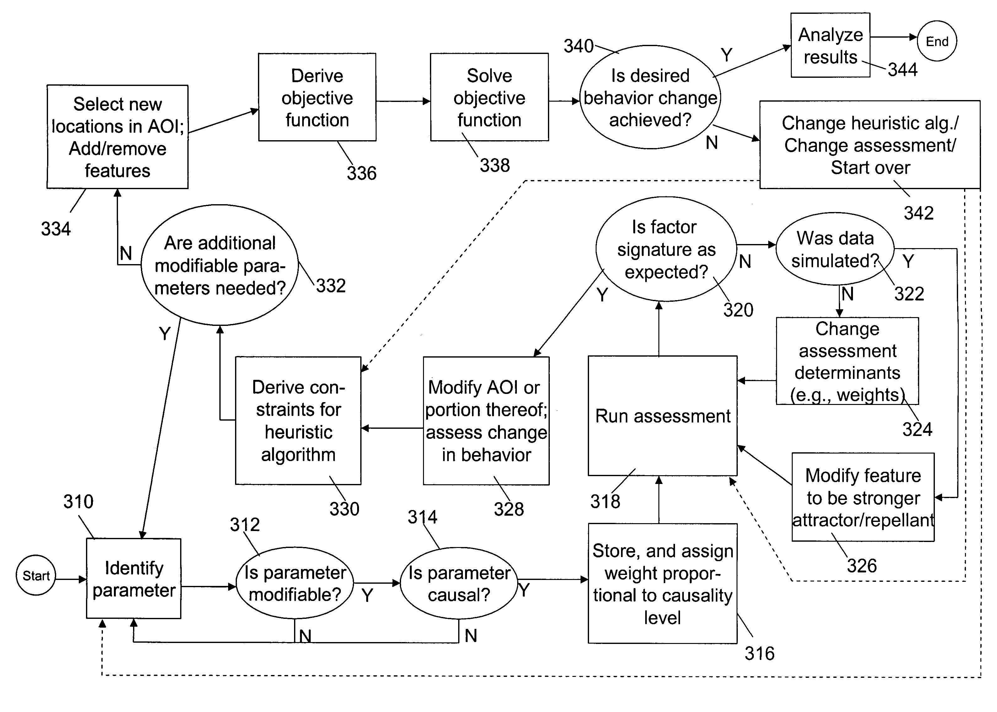
[0126]User C is a shopping mall designer / manager. The flow of shoppers through the facility and their shopping habits is of interest to User C. C creates a spatial assessment of shopping for electronics making use of the invention. User C realizes that there is far too much traffic concentrated at the south entrance to the shopping mall and wishes to move a portion of the traffic to the north entrance area. User C determines that he can modify the locations of valet parking stations, ATM machines, and mall security stations. By examining the attraction-avoidance index for each feature, User C discovers that ATMs and valet parking are attractor features, while security stations are repellors. User C uses the Spatial Behavior Modification tool to find the best locations for the available features, and determines locations for the ATMs, valet parking, and security statio...


PUM


Abstract

Behavioral influences are determined and real-world variables modified according to the present invention. A forecasting engine and method assists in forecasting occurrences of identifiable events and / or results based on signature and / or pattern matching. The present invention derives signature for event-types based on a comparison of actual event data with pre-established representational surfaces. The surfaces represent functional measurements and analysis associated with elements of the geospatial boundary being considered. In one embodiment, the present invention assists in the determination of possible real-world factor influence opportunities in order to influence desired behavior.

Description

STATEMENT REGARDING FEDERALLY SPONSORED RESEARCH[0001]This invention was made with U.S. Government support from the Office of Naval Research, Department of the Navy, under Contract No. N00014-07-C-0193. The U.S. Government has certain rights in the invention.REFERENCE TO RELATED APPLICATIONS[0002]This application claims the benefit of U.S. Pat. No. 7,346,597, filed Apr. 4, 2005 and entitled “Method and System for Event and Result Prediction based on Geospatial Modeling”, the disclosure of which is incorporated herein by reference.TECHNICAL FIELD[0003]The present invention relates to spatial modeling, and more particularly provides a system and method for spatial behavior modification based on geospatial modeling.BACKGROUND ART[0004]Geospatial modeling offers an approach to solutions to a variety of corporate, governmental and individual problems. For example, when a law enforcement or fire department agency seeks to analyze or react efficiently to crimes or fires, respectively, geos...

Claims


Application Information

Patent Timeline
Patent Type & Authority Patents(United States)
IPC IPC(8): G06N5/00
CPCG06K9/00785G06Q10/00G06Q10/04G06Q10/06G06T17/05G09B29/007G06N3/126G06V20/54G06N7/01
Inventor DALTON, JASON R.
Owner MAXAR MISSION SOLUTIONS INC
Why Eureka
Try Eureka