Satellite search method and receiver using the same

a satellite search and receiver technology, applied in the field of satellite search, can solve the problems of taking a long period of time to acquire all visible satellites, how to search all satellites quickly becomes more and more challenging for a receiver, etc., and achieves the effect of efficient rapid reduction of satellite id uncertainty

Active Publication Date: 2010-11-23
MEDIATEK INC
View PDF28 Cites 4 Cited by
  • Summary
  • Abstract
  • Description
  • Claims
  • Application Information

AI Technical Summary

Benefits of technology

[0006]The present invention provides a satellite search method, by which the satellite ID uncertainty can be significantly reduced so that a predetermined or required number of satellites can be rapidly acquired. The present invention also provides a receiver implementing such a method. The method comprises (a) providing a candidate satellite list containing a plurality of satellites; (b) calculating mean visibility of at least one satellite listed in the candidate satellite list for positions with respect to a current time; (c) selecting a satellite from the candidate satellite list according to the mean visibility of each satellite listed in the candidate satellite list; (d) searching the selected satellite to obtain a search result; (e) eliminating at least one position from the possible positions according to the search result; and (f) repeating steps (b) to (e).
[0007]The present invention further provides a receiver for receiving and processing satellite signals to conduct a satellite search, the receiver comprises: a correlation block for correlating the satellite signals with a code of a satellite so as to search the satellite; and a navigation processor for controlling the correlation block, wherein the navigation processor provides a candidate satellite list containing a plurality of satellites, calculates mean visibility of at least one satellite listed in the candidate satellite list for possible positions with respect to a current time, instructs the correlation block to search a satellite which is selected according to the mean visibility of each satellite to obtain a search result, and eliminates at least one position from the possible positions according to the search result.
[0008]According to the present invention, a satellite with the maximum mean visibility is selected from the candidate satellite list to be searched. The search result of the currently searched satellite is used to eliminate impossible positions from the possible positions so as to reduce the uncertainty range.
[0009]In an embodiment of the present invention, each position that the searched satellite is not visible is eliminated if the search result indicates that the searched satellite is acquired, while each position that the searched satellite is visible is eliminated if the search result indicates that the searched satellite is unacquired.
[0011]The present invention further provides a method and a receiver to efficiently reduce satellite ID uncertainty under a situation where time and position are both unknown. One specific time sample and one specific position define a time-space point. Impossible time-space points are eliminated from possible positions according to each search result. By doing so, the satellite ID uncertainty can be rapidly reduced.

Problems solved by technology

Therefore, how to search all the satellites quickly becomes more and more challenging for a receiver.
It will take a very long period of time to acquire all the visible satellites by using the conventional sequential search method.

Method used


Image

  • Satellite search method and receiver using the same
  • Satellite search method and receiver using the same
  • Satellite search method and receiver using the same

Examples


Embodiment Construction

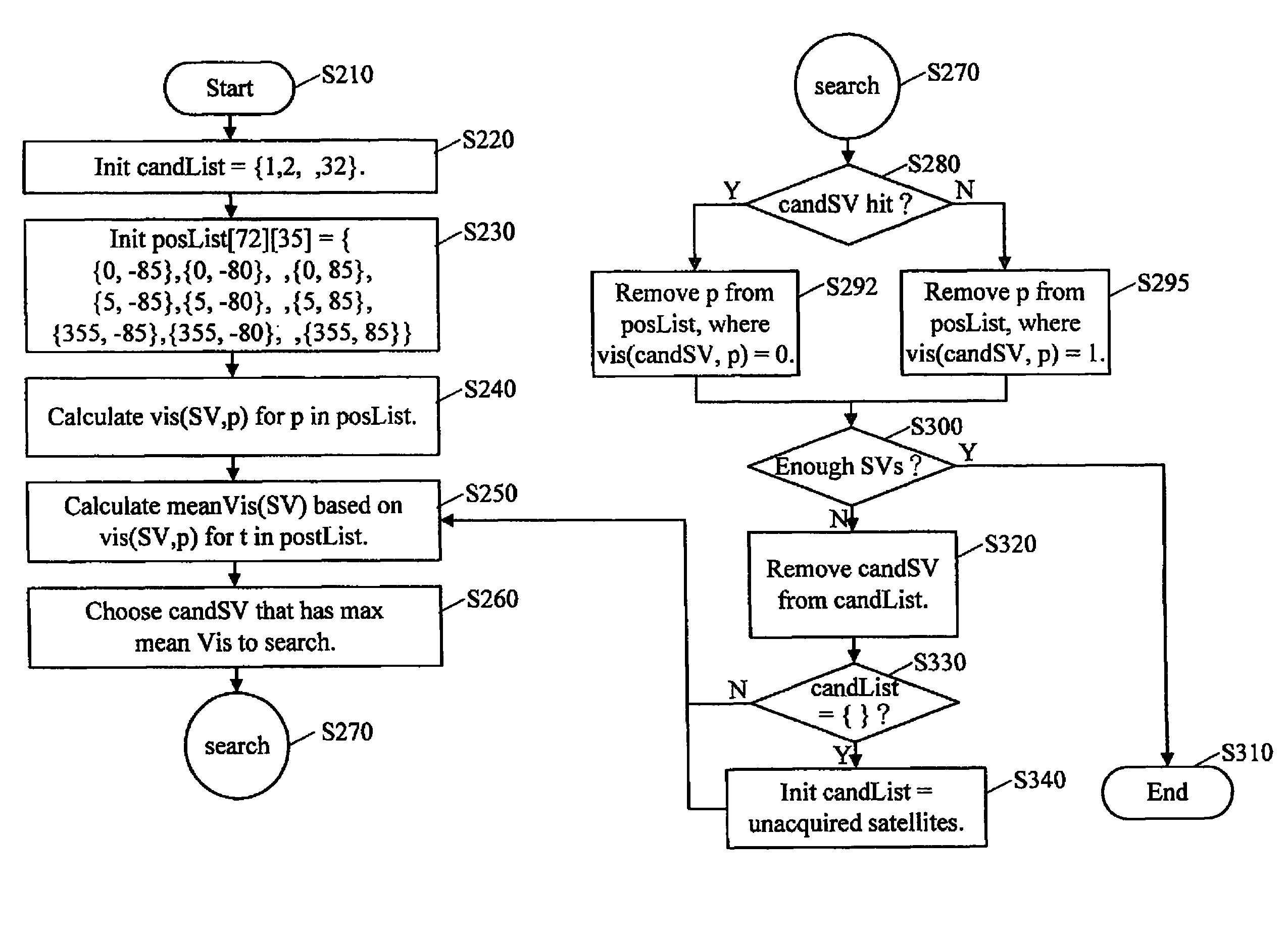
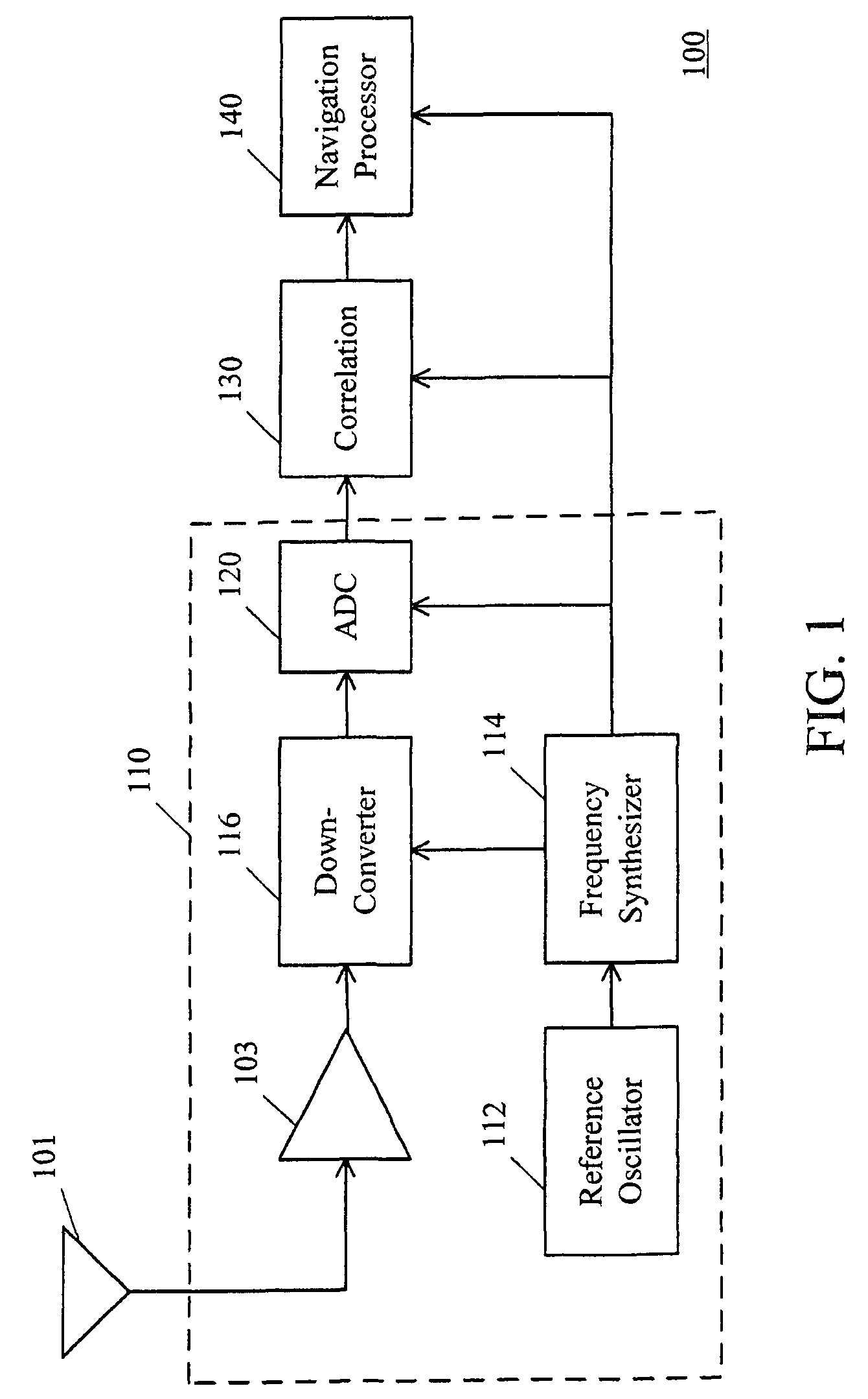
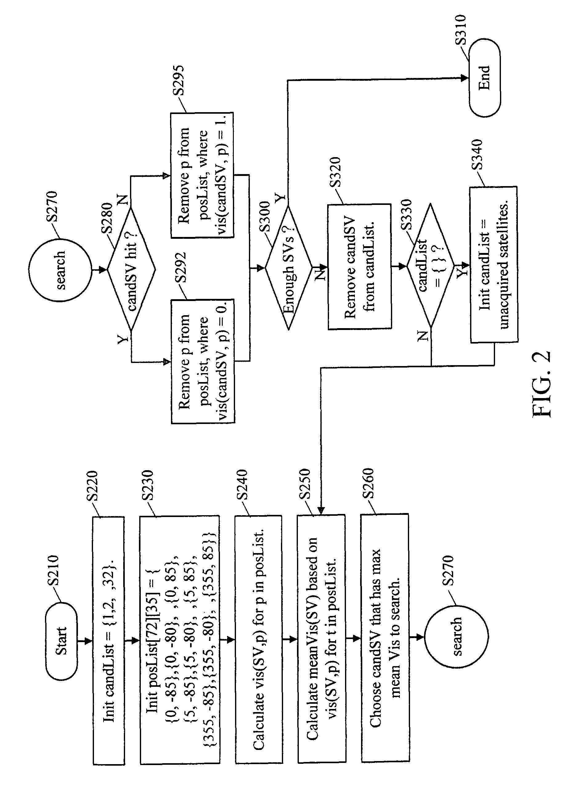
[0019]When a receiver starts, the first task is to search all the visible satellites in the sky. Satellite visibility relates to a user's position, system time (e.g. GPS time) and satellite orbital information. The satellite orbital information is from data collected in the last fixing of the receiver or from a remote aiding data server. The receiver can determine the satellite visibility by checking an elevation angle of a satellite with respect to the receiver, for example. A specific satellite is deemed as visible when the elevation angle is greater than 5 degrees. Otherwise, this satellite is deemed as invisible. However, in addition to the elevation angle of the satellite with respect to the receiver's position, the visibility of each satellite can be determined by any other proper method. The satellite visibility can be expressed as a function of the user's position, the system time and the satellite orbit information. If the user's rough position, the rough time (e.g. time pr...


PUM


Abstract

A satellite search method and a receiver implementing such a method are disclosed. In the present invention, a predetermined range is sampled into multiple possible positions or space-time points, each of which is defined by a specific position and a time sample. The possible positions or points are sieved according to a search result of a satellite selected from candidate satellites each time. By repeatedly doing so, the finally remaining position will approach a user's position, and accordingly the candidate satellites converge to the most possible ones as to facilitate satellite search.

Description

RELATED APPLICATIONS[0001]The present application is a continuation-in-part of prior U.S. patent application Ser. No. 11 / 392,976, entitled: “COLD START SATELLITE SEARCH METHOD”, filed on Mar. 28, 2006, and U.S. patent application Ser. No. 11 / 566,009, entitled “SATELLITE SEARCH METHOD”, filed on Dec. 1, 2006. The entirety of each application is hereby incorporated herein by reference.TECHNICAL FIELD OF THE INVENTION[0002]The present invention relates to a satellite searching, more particularly, to a method for dynamically and rapidly searching satellites and a receiver implementing such a method.BACKGROUND OF THE INVENTION[0003]Nowadays, multiple Global Navigation Satellite System (GNSS) are available, including GPS (Global Positioning System) of US, which is designed to have 32 operational satellites, Galileo of Europe, which is designed to have 27 operational satellites, GLONASS (GLObal NAvigation Satellite System) of USSR (and later Russia), which is designed to have 24 operationa...

Claims


Application Information

Patent Timeline
Patent Type & Authority Patents(United States)
IPC IPC(8): G01S19/28G01S19/31G01S19/04G01S19/07G01S19/11G01S19/48
CPCG01S19/28
Inventor CHEN, KUN-TSO
Owner MEDIATEK INC
Why Eureka
Try Eureka