Systems and methods for location-based real estate service

a technology of location-based real estate and system, applied in the field of mapping systems and methods, can solve the problems of difficult to quickly compare two houses, mls does not provide a consolidated view of all houses, and the database of multiple listing services does not provide location-based aggregations of information

Active Publication Date: 2011-11-01
ENT SERVICES DEV CORP LP
View PDF21 Cites 117 Cited by
  • Summary
  • Abstract
  • Description
  • Claims
  • Application Information

AI Technical Summary

Problems solved by technology

However, existing MLS (Multiple Listing Service) databases do not provide location-based aggregations of information.
For example, the MLS does not provide a consolidated view of all the houses matching the buyer's criteria.
This makes it difficult to quickly compare two houses.
The MLS does not provide any easy way to look at relative geographical locations of two houses.
The MLS does not provide any easy way to add personal notes for houses.
The MLS does not provide any easy way to add any other information, such as school ratings, school districts, traffic patterns, shop locations, county and city tax rates, etc. in a geographic specific manner.
Some prior art solutions, such as the MLS, may involve databases that store location information and pictorial information together, but do not provide an integrated way of browsing and searching them.
There is no easy way to search using a map based interface.
In addition, a potential buyer cannot easily independently verify lot size.
Further, there is no systematic way of recording the houses that the potential buyer has physically visited for comparison purposes.

Method used


Image

  • Systems and methods for location-based real estate service
  • Systems and methods for location-based real estate service
  • Systems and methods for location-based real estate service

Examples


Embodiment Construction

[0020]This disclosure of the invention is submitted in furtherance to the constitutional purposes of the U.S. Patent Laws to promote the progress of science and the useful arts.

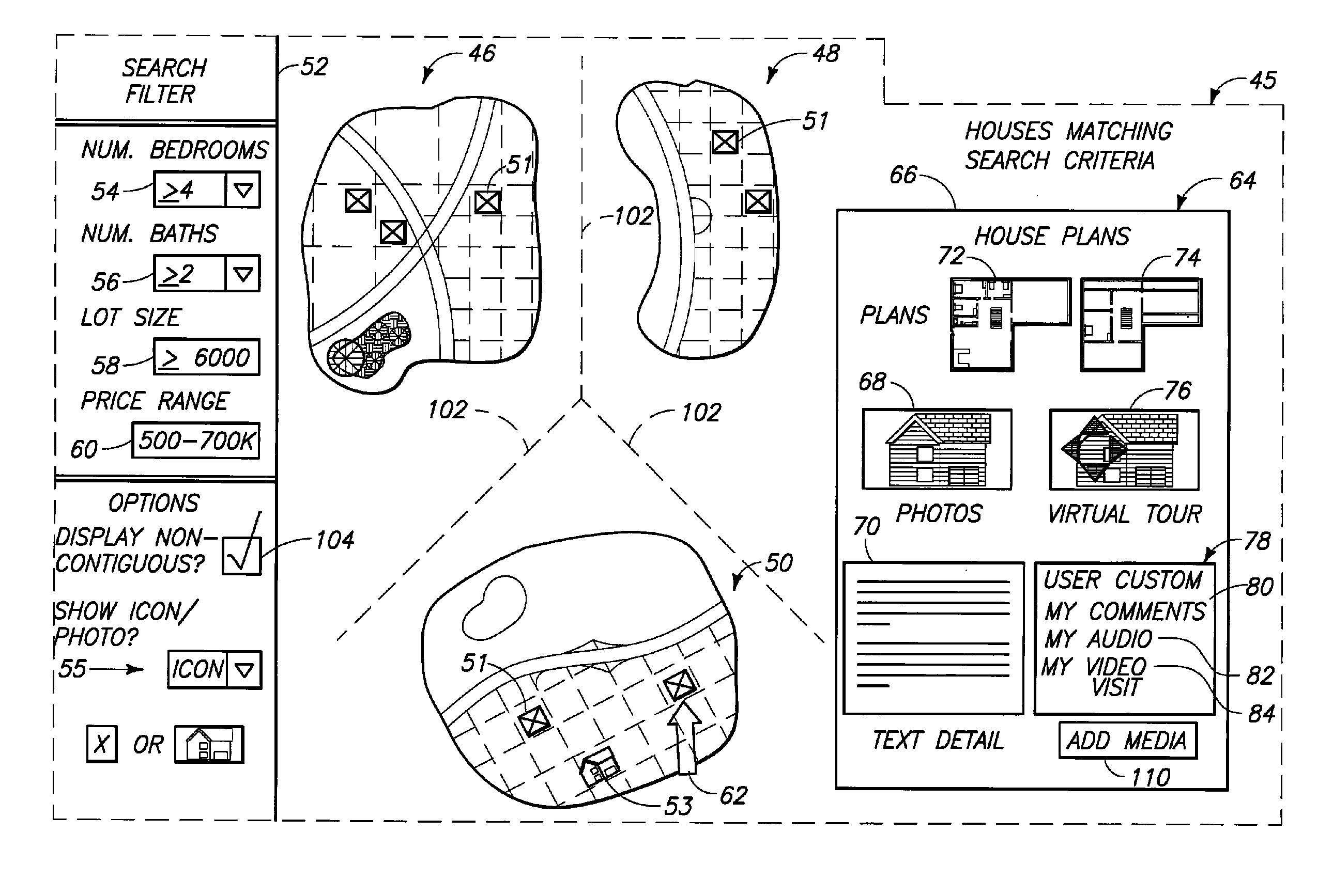
[0021]FIG. 1 shows a geo-spatial system 10 embodying various aspects of the invention. The system 10 includes at least some of a data capture unit 12, a data storage unit 14, an area measurement unit 16, a personalization unit 18, and a display unit 20.

[0022]The data capture unit 12 includes, for example, a digital camera 22 and a GPS receiver 24. The data capture unit 12 is selectively used to capture multimedia data along with GPS information. The GPS information can be used to determine location information corresponding to the captured multimedia data. Multimedia data can include photo, video, and / or audio data.

[0023]The data storage unit 14 stores information about real estate properties. More particularly, the data storage unit 14 includes a database which stores the multimedia data captured by the data...


PUM


Abstract

A system and method for searching real estate properties, a system and method for estimating the size of an area, and a system and method for associating an image with information relevant to the image is disclosed. A system for searching real estate properties comprises a data storage unit configured to store map information, additional relevant georeferenced information and information about real estate properties, including information identifying the locations of the real estate properties; and a display unit configured to receive a search request from a user, communicate with the data storage unit, and provide search results to the user, including a map showing locations of real estate properties, in response to the search request, the display unit being further configured to displaying a user interface with which the user may associate information, personal to the user, with a particular real estate property.

Description

FIELD OF THE INVENTION[0001]The invention relates to mapping systems and methods. The invention also relates to multimedia systems and methods, and to GPS systems and methods.BACKGROUND OF THE INVENTION[0002]There is a well known maxim that, in real estate, the three most important things are: location, location, location. However, existing MLS (Multiple Listing Service) databases do not provide location-based aggregations of information. For example, the MLS does not provide a consolidated view of all the houses matching the buyer's criteria. This makes it difficult to quickly compare two houses. The MLS does not provide any easy way to look at relative geographical locations of two houses. The MLS does not provide any easy way to add personal notes for houses. The MLS does not provide any easy way to add any other information, such as school ratings, school districts, traffic patterns, shop locations, county and city tax rates, etc. in a geographic specific manner.[0003]Some prior...

Claims


Application Information

Patent Timeline
Patent Type & Authority Patents(United States)
IPC IPC(8): G06F17/30G06Q30/06
CPCG06Q30/06
Inventor GARGI, ULLASSAMADANI, RAMINLIN, QIAN
Owner ENT SERVICES DEV CORP LP
Why Eureka
Try Eureka