Adjusting spatial operations based on map density

a technology of spatial operations and density, applied in the field of adjusting spatial operations based on density, can solve the problems of reducing screen readability, increasing the time to update the view, and not being desirable to have map views with very few features

Active Publication Date: 2011-12-13
MITAC INT CORP
View PDF147 Cites 38 Cited by
  • Summary
  • Abstract
  • Description
  • Claims
  • Application Information

AI Technical Summary

Benefits of technology

[0008]It is, therefore, an object of the present invention to resolve one or more of the foregoing difficulties by providing a method that automatically keeps the similar density of the displayed map features by deciding in real time which features should be displayed at a given location and zoom level.
[0009]This auto adjustment may be achieved by efficiently estimating in real time map density for different possible combination of map features and displaying the best found feature combination.

Problems solved by technology

For example, it is not desirable to have too crowded map views which reduce screen readability and increase the time to update the view.
At the same time, it is not desirable to have map views with very few features and which do not provide enough navigation information.
The problem can be critical for mobile devices having small screens.
The non-uniformity of feature density increases map developers difficulty in designing map views which work well both in urban areas and rural areas.
Because the class of features is predefined for the entire map, by its nature it has to be an average and may be too dense or too sparse for some regions of the map.
The prior approach is extremely cumbersome for users especially if a mapping device is used while driving, biking, or any other similar activity when the user's hands and attention may be occupied.
Street routing algorithms also suffer from a non-uniformity of feature density.
Prior approaches predefine the criteria constant everywhere in a given map thereby making the routing algorithm impossible to generate street routes with optimal quality and search time in both urban and rural areas.
If a predefined search radius is used, the nearest search function may yield no result, too many results, or take too much time.
Even if the search radius is adjusted based on search results, each search iteration can take significant time.

Method used


Image

  • Adjusting spatial operations based on map density
  • Adjusting spatial operations based on map density
  • Adjusting spatial operations based on map density

Examples


Embodiment Construction

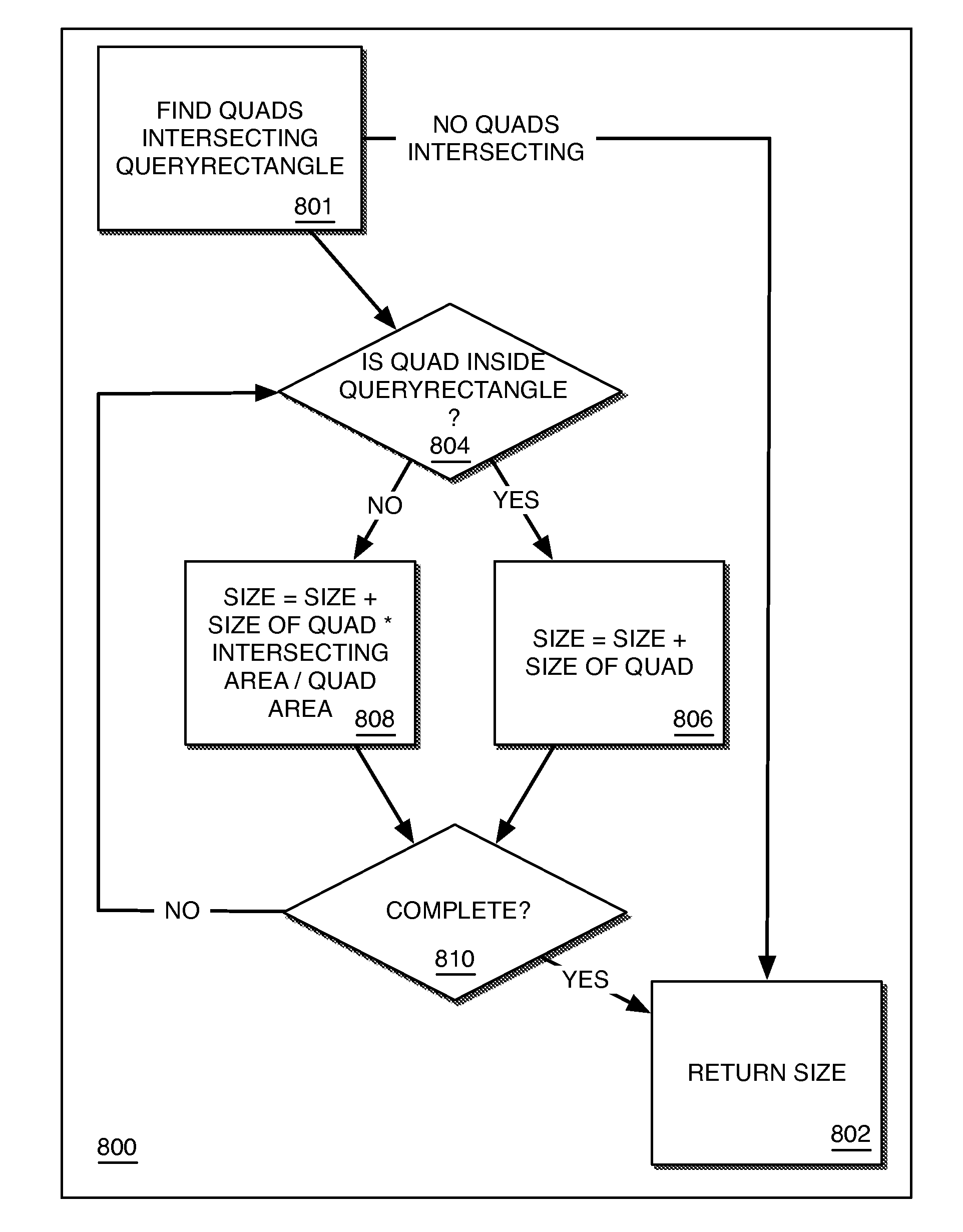
[0030]A method and an apparatus for estimating map density are described along with automatically retaining a similar density of displayed map features by adjusting in real time visible features at a given location and zoom level. Methods automatically adjusting street routing and nearest (proximity) search are also described. In at least some embodiments, the adjustment of map display density, street routing and nearest search may be performed in an optimal and / or efficient manner. In the following description, for purposes of explanation, numerous specific details are set forth in order to provide a thorough understanding of the present invention. It will be apparent, however, that the present invention may be practiced without these specific details. In other instances, well-known structures and devices are shown in block diagram form in order to avoid unnecessarily obscuring the present invention.

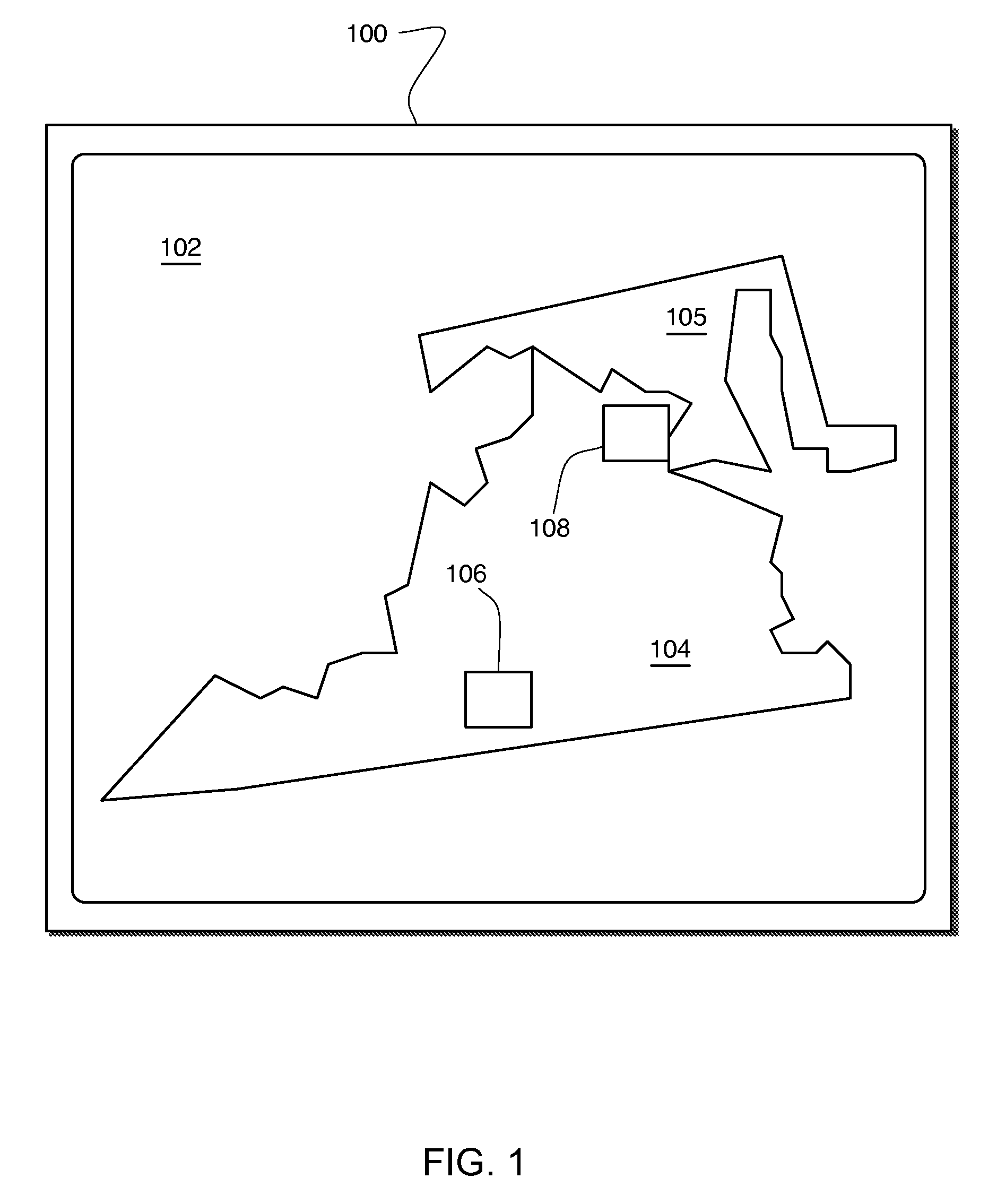
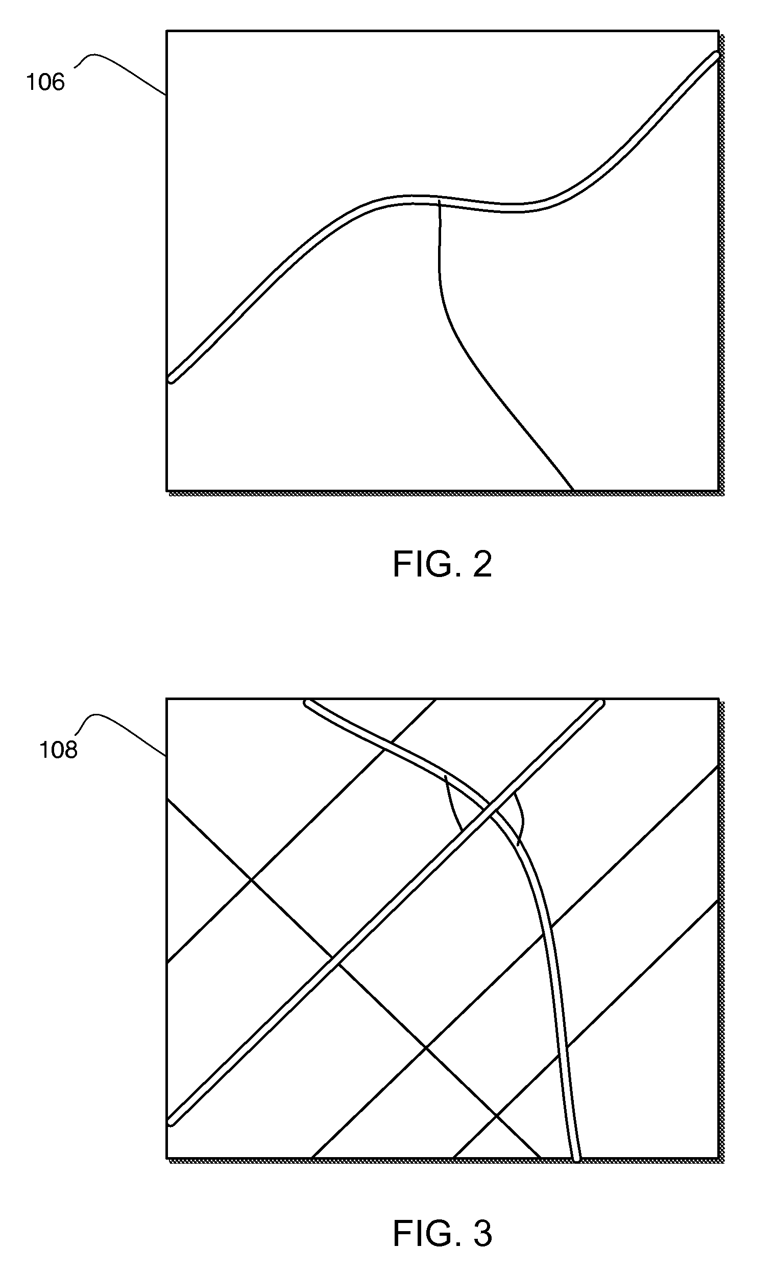
[0031]FIG. 1 depicts a display 100 of a portion of a map 102 depicting a geographic...


PUM


Abstract

A method of determining density of a map is described along with an apparatus and computer-readable medium comprising instructions therefore. The method comprises determining one or more nodes of a quad tree applied to a map with which a predetermined query region intersects, calculating a cumulative data size of the query region based on a data size of the one or more intersecting nodes, and determining an average density of the query region based on the query region area and the cumulative data size.

Description

BACKGROUND[0001]Mobile mapping applications, e.g., mapping applications for execution on mobile devices such as global positioning system (GPS)-based devices, are often executed on computer-based platforms having a slower central processing unit (CPU) and limited memory in comparison to desktop computer-based platforms. Upfront knowledge of mobile mapping application resource requirements, e.g., CPU speed, memory space, etc., enables better use of the limited resources available on the computer-based platforms, improves performance of the application and provides an improved user experience during interaction with the application.[0002]In mobile mapping applications, many spatial operations, e.g., map display, nearest search and street routing, depend on map density. Map density refers to the amount of information and / or features displayed on a given area of a displayed map. For example, it is not desirable to have too crowded map views which reduce screen readability and increase t...

Claims


Application Information

Patent Timeline
Patent Type & Authority Patents(United States)
IPC IPC(8): G06F7/00G06F17/30G06T17/05
CPCG06F17/30241G06F16/29
Inventor MAO, AILINLOKSHIN, ANATOLEUPPARAPALLI, NIDHI
Owner MITAC INT CORP
Why Eureka
Try Eureka