
Integration of real-time field data in chemical delivery vehicle operations

a technology of chemical delivery vehicle and real-time field data, which is applied in the direction of traffic control system, navigation instrument, instruments, etc., can solve the problems of limited use of gis, high cost of deploying data collectors for gis systems, and large number of dedicated gis data collectors

Active Publication Date: 2013-02-26
TRIMBLE NAVIGATION LTD
View PDF9 Cites 51 Cited by
  • Summary
  • Abstract
  • Description
  • Claims
  • Application Information

AI Technical Summary

Benefits of technology

This solution reduces unauthorized stops and errors, ensures proper chemical delivery, and optimizes vehicle routes, enhancing operational efficiency and reducing costs by leveraging real-time data for near-real-time tracking and management of chemical delivery vehicles.

Problems solved by technology

However, there are several factors which limit the use of GIS.
One factor is the cost of deploying data collectors for GIS systems.
Dedicated GIS data collectors are often large (e.g., up to 4-5 pounds) and expensive ($1500-$5000) per unit.
Additionally, at the end of the day, bottlenecks in downloading the collected data may occur if all of the users are at the office at the same time.

Method used


Image

  • Integration of real-time field data in chemical delivery vehicle operations
  • Integration of real-time field data in chemical delivery vehicle operations
  • Integration of real-time field data in chemical delivery vehicle operations

Examples


example geographic

INFORMATION SYSTEMS (GIS) TECHNOLOGY

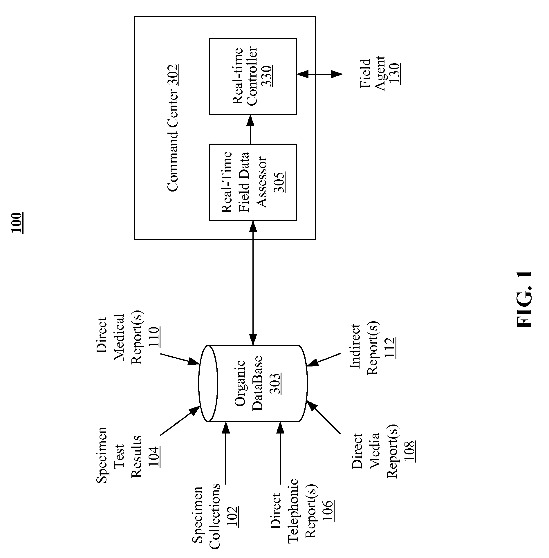
[0064]One embodiment of the method and system for integrating the real-time field data collection, real-time command and control of chemical delivery from a vehicle and real-time analysis results from collected field data utilizes GIS. An example of GIS is provided herein for purposes of clarity and enablement. However, the present system and methods discussed herein are also well suited for data collection and collaboration systems and methods. The utilization of GIS is merely one of a plurality of possible geo-spatial data collection networks which would be suitable for utilization with one or more embodiments described herein.

[0065]A geographic information system (GIS) is a technological tool for comprehending geography and making intelligent decisions. GIS organizes geographic data so that a person reading a map can select data necessary for a specific project or task. A thematic map has a table of contents that allows the reader to add layers...


PUM


Abstract

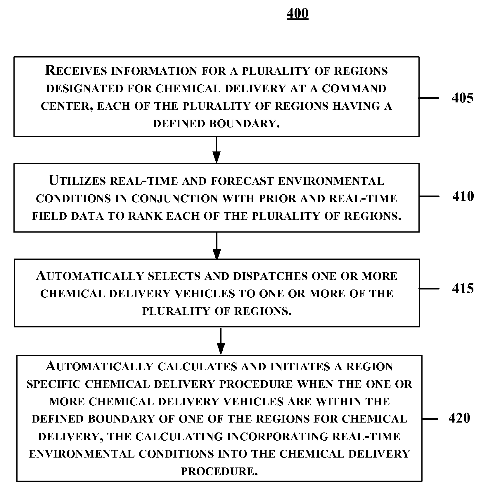
A method and system for integration of real-time field data in chemical delivery vehicle operations is disclosed. Initially, information for a plurality of regions designated for chemical delivery is received at a command center, each of the plurality of regions having a defined boundary. Real-time and forecast environmental conditions are utilized in conjunction with prior and real-time field data to rank each of the plurality of regions. One or more chemical delivery vehicles are automatically selected and dispatched to one or more of the plurality of regions. When the one or more chemical delivery vehicles are within the defined boundary of one of the plurality of regions for chemical delivery, region specific chemical delivery procedures incorporating real-time environmental conditions are automatically calculated and initiated.

Description

FIELD[0001]The invention relates to integration of real-time field data in chemical delivery vehicle operations.BACKGROUND[0002]Geographic information systems (GIS) technology is increasingly used to provide geo-spatial data to a wide variety of business, government, and academic applications. GIS is often described as a collection of computer hardware, software, geographic data, and personnel which combine to record, store, process, interpret, and distribute geographically referenced data. GIS permit users to selectively interpret geo-spatial data in order to identify relationships, patterns, or trends that may not be readily discerned using traditional charts, graphs, or spreadsheets.[0003]However, there are several factors which limit the use of GIS. One factor is the cost of deploying data collectors for GIS systems. Dedicated GIS data collectors are often large (e.g., up to 4-5 pounds) and expensive ($1500-$5000) per unit. Adding to the expense per-unit is the need for a consol...

Claims


Application Information

Patent Timeline
Patent Type & Authority Patents(United States)
IPC IPC(8): G06Q40/00
CPCG06Q10/047G06Q10/0631G06Q50/28G06Q10/08
Inventor HAND, LYNN
Owner TRIMBLE NAVIGATION LTD
Learn More