Emergency location information gateway for public safety answering points (PSAPs) and method of use

a technology of emergency location information and public safety, applied in the field of automatic processing of location information, can solve the problems of inability to accuracy, and the like, and the prior art methods of accomplishing such locations do not meet the requirements of rapid location determination, automation, and accuracy

Active Publication Date: 2013-05-14
EVERBRIDGE
View PDF66 Cites 61 Cited by
  • Summary
  • Abstract
  • Description
  • Claims
  • Application Information

AI Technical Summary

Problems solved by technology

For example, in the event of a fire, public safety personnel may need to operate within an unfamiliar building on short notice, in conditions of poor visibility due to smoke or flame.
Prior art methods of accomplishing such location do not simultaneously meet the requirements of rapid location determination, automation, and accuracy.
Navigation employing conventional maps and visual observation or dead reckoning are not readily automated and thus require time and attention by a human observer.
There are many problems associated with determining a location of device and a caller who needs to place an E911 call in an emergency.
On problem is that many E911 calls a misrouted to the wrong PSAP.
This can delay the dispatch of emergencies services to the caller.
Another problem is that existing mobile technology makes its difficult to accurately locate mobile devices.
Another problem is that triangulation based on time of arrival at multiple mobile-communications base stations (TDOA) has inadequate coverage and is insufficiently accurate unless supplemented by signals provided by local radios placed outside the facility by public safety personnel.
Another problem is that conventional radio-frequency-based location methods do a poor job of providing topological location within a building: that is, location relative to walls, doors, partitions, stairways, and other features whose spatial extent is small but whose significance to a person's ability to move is great.
Another problem is that many mobile devices are not “location-aware.” Location-aware devices are aware of their current geographic location.
However, mobile telephones may only determine their current geographic location by communicating with a particular mobile phone interface or telephony switch that provides coverage to a geographic location such as a telephony “cell” but not an exact current geographic location within the cell.
Another problem is that many communications networks do not correctly provide emergency location information to public service answering points (PSAPs).

Method used


Image

  • Emergency location information gateway for public safety answering points (PSAPs) and method of use
  • Emergency location information gateway for public safety answering points (PSAPs) and method of use
  • Emergency location information gateway for public safety answering points (PSAPs) and method of use

Examples


Embodiment Construction

Exemplary Electronic Information Message Processing System

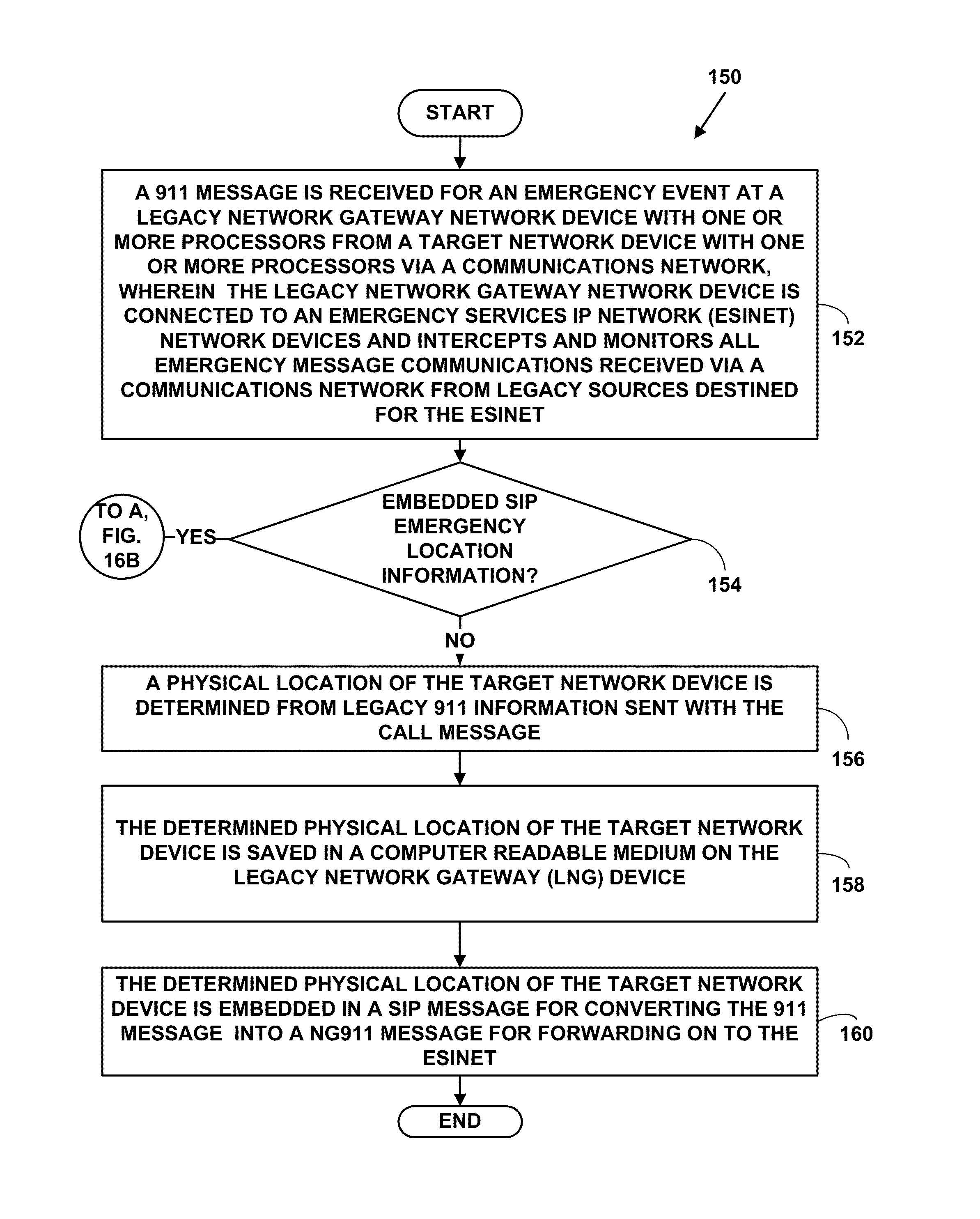
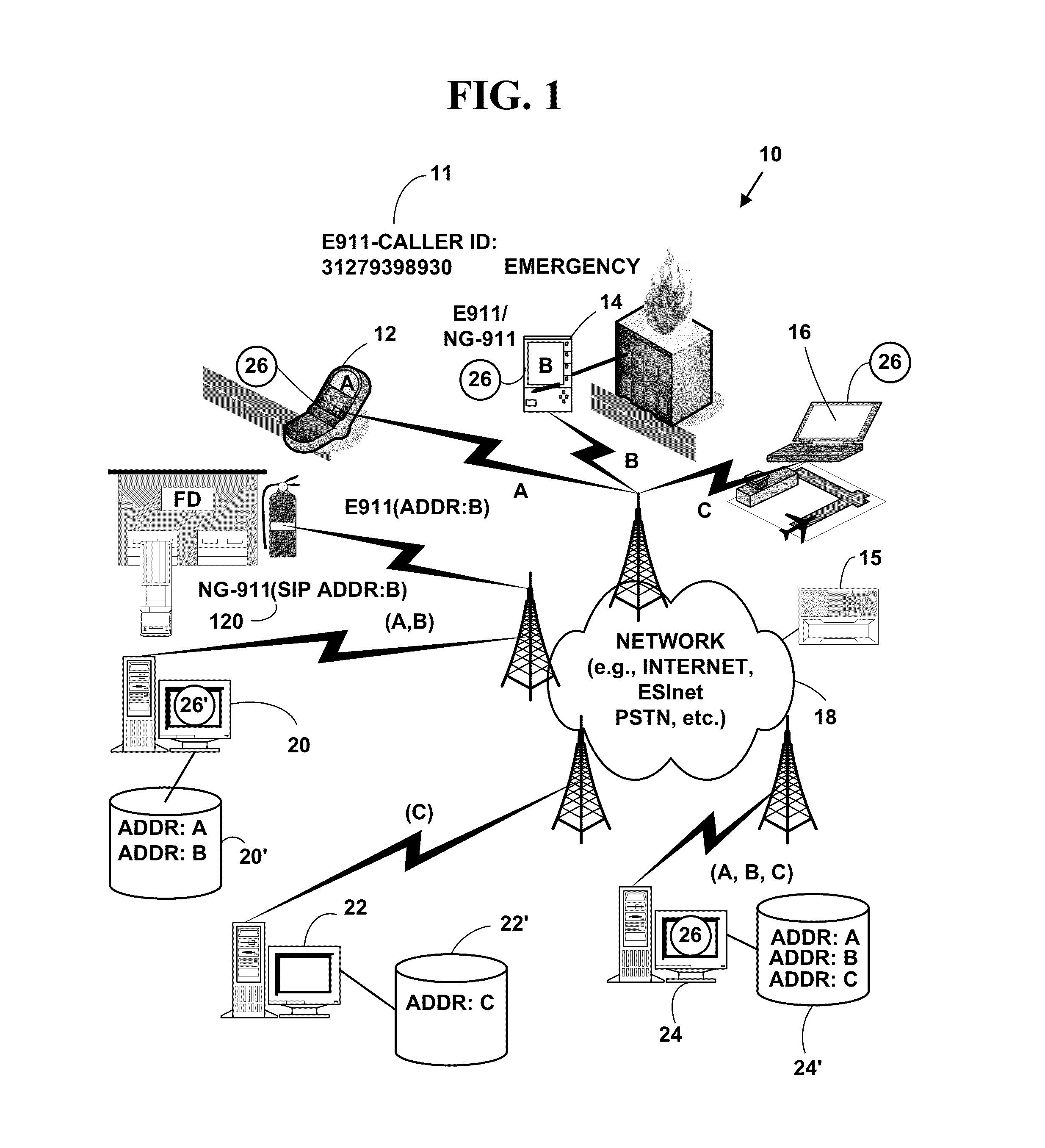
[0035]FIG. 1 is a block diagram illustrating an exemplary communications system 10. The exemplary communications system 10 includes, but is not limited to, one or more target network devices 12, 14, 16 (only three of which are illustrated). The target network devices 12, 14, 16 include, but are not limited to, mobile phones, non-mobile phones, non-mobile computers, wireless devices, wired devices, game devices, laptop computers, personal information devices, personal digital / data assistants (PDA), hand-held devices, network appliances, Internet appliances, two-way pagers, etc. However, the present invention is not limited to these target electronic devices and more, fewer or others types of target electronic devices can also be used. The target network devices 12, 14, 16 function as client devices in some instances and server devices in other instances. The target network devices 12, 14, 16 may be wireless or wired as illustr...


PUM


Abstract

The emergency location information gateway provides Public Safety Answering Points (PSAPs) with the capability to receive NG911-compliant (i.e., Session Initiation Protocol (SIP-based) and / or SIP-Voice over Internet Protocol (VoIP)) and other types emergency calls including embedded emergency location information and determine a physical location of a mobile or non-mobile target network device based on the embedded emergency location information. Conversely, a legacy network gateway (LGN) enables the conversion of traditional 911, and E911 calls into NG911 calls for transport and dissemination by so-called Emergency Services IP networks, or ESInets.

Description

CROSS REFERENCES TO RELATED APPLICATIONS[0001]This utility patent application is a Continuation-In-Part (CIP) of U.S. utility application 11 / 803,671, filed May 15, 2007, which claims priority to U.S. Provisional patent application Nos. 60 / 800,774, 60 / 800,775, 60 / 800,776, 60 / 800,777, all filed May 16, 2006, U.S. utility application 11 / 803,671 issued as U.S. Pat. No. 7,937,067 on May 3, 2011, the contents of all of which is incorporated by reference. This utility application also claims priority to U.S. Provisional patent application Nos. 61 / 229,414, filed Jul. 29, 2009, and 61 / 230,154, filed Jul. 31, 2009, the contents of all of which are also incorporated by reference.FIELD OF INVENTION[0002]This application relates to automatic processing of location information. More specifically, it relates to an emergency location information gateway for public service answering points (PSAP) and a method of use.BACKGROUND OF THE INVENTION[0003]In many emergency situations it is of great importa...

Claims


Application Information

Patent Timeline
Patent Type & Authority Patents(United States)
IPC IPC(8): H04M11/04
CPCH04W64/00H04W4/22H04W76/007H04W4/02H04W4/90H04W76/50H04W4/029
Inventor MAIER, NICHOLAS M.MERTKA, WILLIAM L.
Owner EVERBRIDGE
Why Eureka
Try Eureka