Processing multi-GNSS data from mixed-type receivers
What is AI technical title?
AI technical title is built by Patsnap AI team. It summarizes the technical point description of the patent document.
a multi-gnss and receiver technology, applied in surveying, navigation, instruments, etc., can solve problems such as network data processing and data post-processing, and the signal structure implemented in glonass presents problems for real-time kinematic (rtk) data processing
Active Publication Date: 2014-04-08
TRIMBLE NAVIGATION LTD
View PDF9 Cites 29 Cited by
Summary
Abstract
Description
Claims
Application Information
AI Technical Summary
This helps you quickly interpret patents by identifying the three key elements:
Problems solved by technology
Method used
Benefits of technology
Problems solved by technology
The signal structure implemented in GLONASS presents problems for Real-Time Kinematic (RTK) data processing as well as network data processing and data post-processing.
Method used
Image
Click on the blue label to locate the original text in one second.
Reading with bidirectional positioning of images and text.
Examples
Embodiment Construction
[0030]Overview
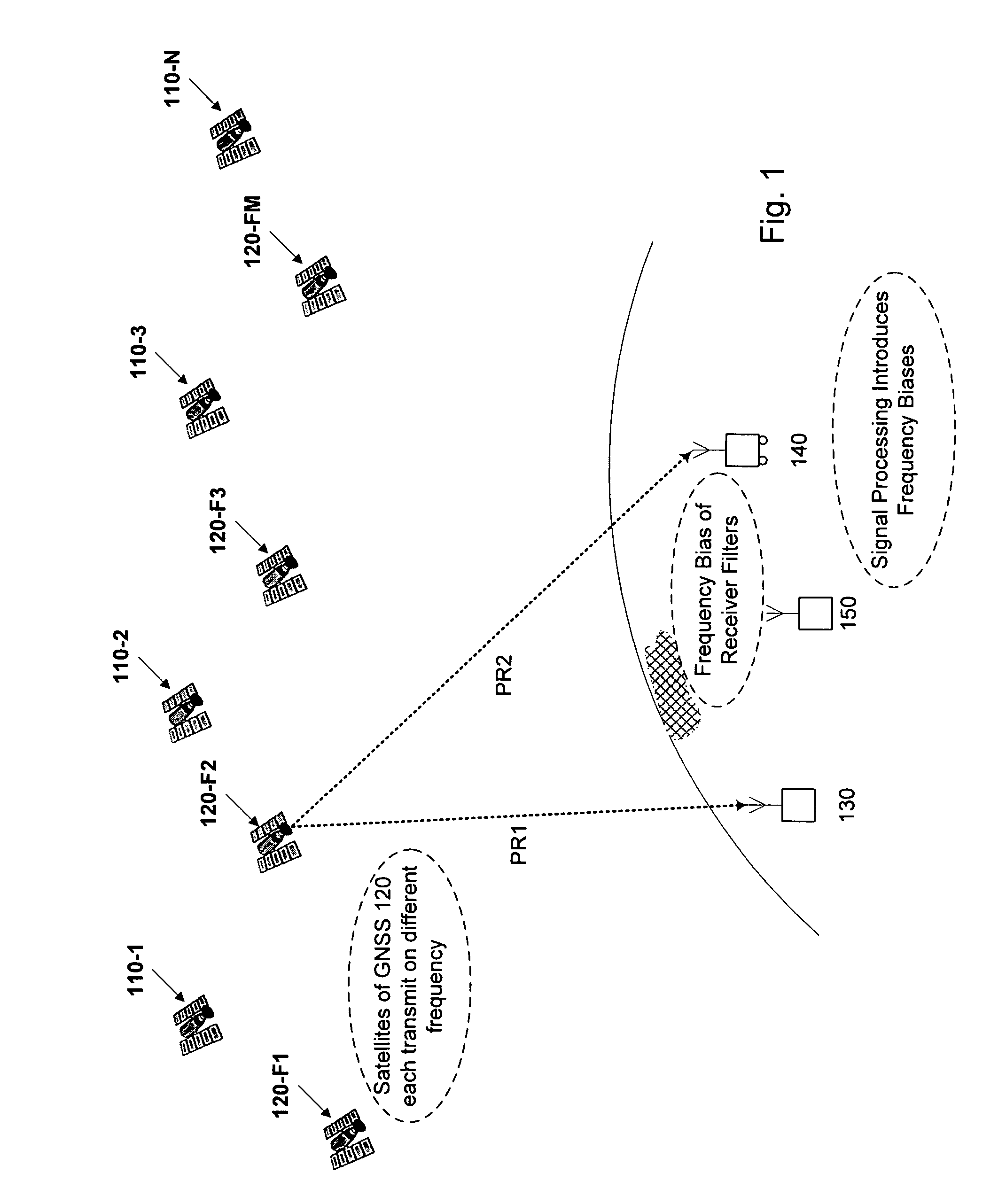
[0031]FIG. 1 schematically illustrates a scenario using two GNSS (110, 120) with receivers of different types having different frequency biases, such as a reference station 130 from a first manufacturer and a rover 140 from a second manufacturer. GNSS 110 is a CDMA system such as GPS. GNSS 120 is an FDMA system such as GLONASS. Reference station 130, rover 140, and one or more additional reference stations 150, if provided, each receive GNSS signals from any number of satellites of a first GNSS, such as satellites 110-1, 110-2, . . . , 110-N, and from any number of satellites of a second GNSS, such as satellites 120-F1, 120-F2, . . . , 120-FM. Respective pseudoranges, PR1, PR2, etc. from each satellite are to be determined from GNSS signal data collected at the receivers.
[0032]Pseudo-range can be determined for example using the GPS C / A code with an error of about one meter. A civil GPS receiver not using the military-only P / Y code determines rover position with an err...
PUM
Abstract
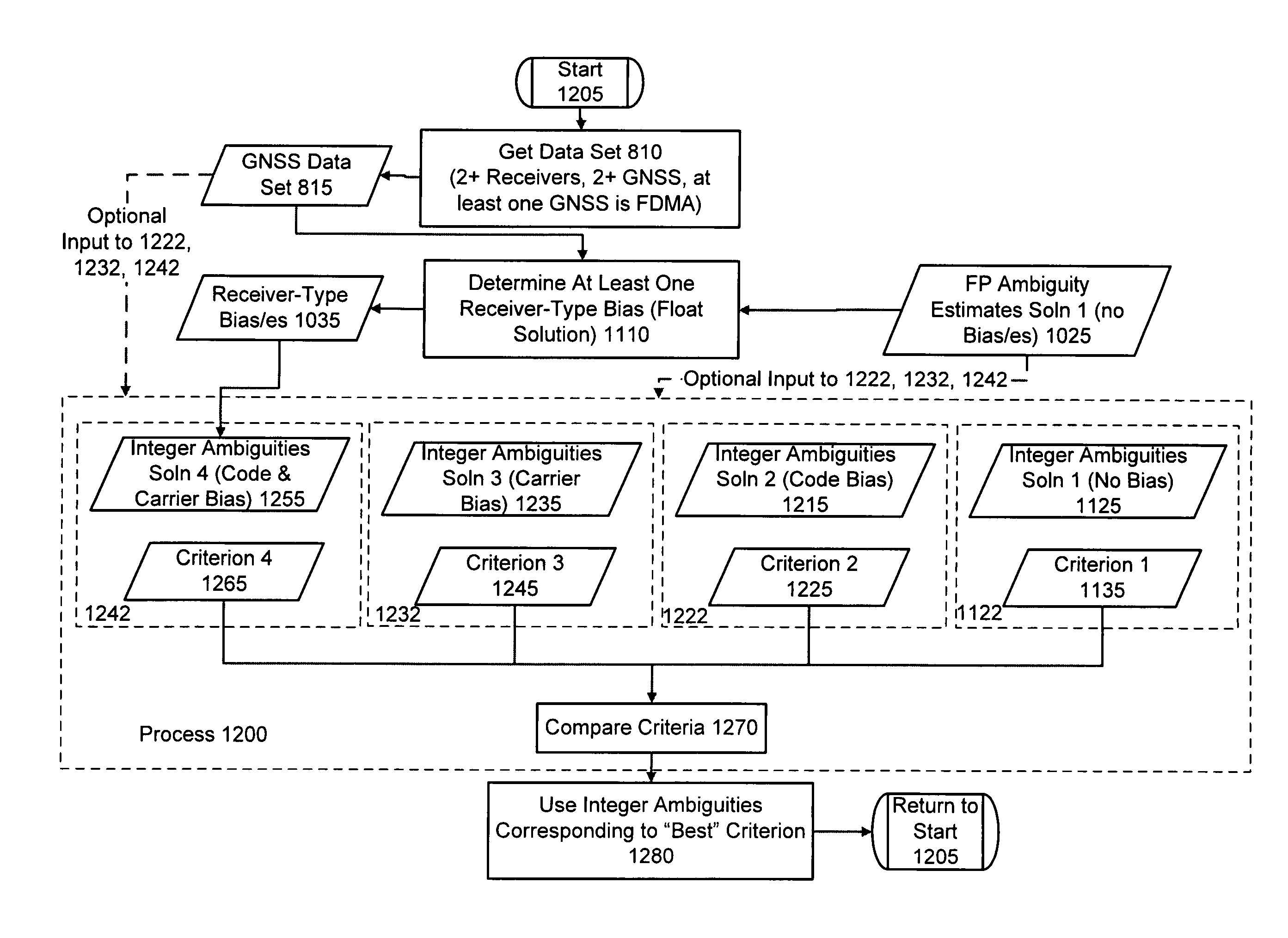
Computer-implemented methods and apparatus are presented for processing data collected by at least two receivers from multiple satellites of multiple Global Navigation Satellite Systems (GNSS), where at least one GNSS is Frequency Division Multiple Access (FDMA). Data sets are obtained which comprise a first data set from a first receiver and a second data set from a second receiver. The first data set comprises a first FDMA data set and the second data set comprises a second FDMA data set. At least one of a code bias and a phase bias may exist between the first FDMA data set and the second FDMA data set. At least one receiver-type bias is determined, to be applied when the data sets are obtained from receivers of different types. The data sets are processed, based on the at least one receiver-type bias, to estimate carrier floating-point ambiguities. Carrier integer ambiguities are determined from the floating-point ambiguities. The scheme enables Globalnaya Navigatsionnaya Sputnikovaya Sistema (GLONASS) carrier phase ambiguities to be resolved and used in a combined FDMA / Code Division Multiple Access (CDMA)(e.g., GLONASS / Global Positioning System (GPS) centimeter-level solution. It is applicable to real-time kinematic (RTK) positioning, high-precision post-processing of positions and network RTK positioning.
Description
CROSS REFERENCE TO RELATED APPLICATIONS[0001]This application claims benefit of U.S. Provisional Application for Patent No. 61 / 010,601, filed Jan. 9, 2008, the content of which is incorporated herein by this reference.[0002]The content of U.S. patent application: VOLLATH U., “Ambiguity Estimation of GNSS Signals for Three or more Carriers,” application Ser. No.: 10 / 696,528 filed Oct. 28, 2003, Pub. No.: US 2005 / 0101248 A1 published May 12, 2005 is incorporated herein by this reference. The content of U.S. Pat. No. 7,312,747, VoLLATH U. and DOUCET K., “Multiple-GNSS and F DMA High-Precision Carrier-Phase Based Positioning,” dated Dec. 25, 2007 is incorporated herein by this reference. application Ser. No. 11 / 983,926, filed Nov. 12, 1987 an published as US 2008 / 0165055 on Jul. 10, 2008 and application Ser. No. 11 / 983,925, filed Nov. 12, 1987 and Published as US 2008 / 0165054 on Jul. 10, 2008 are continuation of U.S. Pat. No. 7,312,747.FIELD OF THE INVENTION[0003]The present invention r...
Claims
Application Information
Patent Timeline
Application Date:The date an application was filed.
Publication Date:The date a patent or application was officially published.
First Publication Date:The earliest publication date of a patent with the same application number.
Issue Date:Publication date of the patent grant document.
PCT Entry Date:The Entry date of PCT National Phase.
Estimated Expiry Date:The statutory expiry date of a patent right according to the Patent Law, and it is the longest term of protection that the patent right can achieve without the termination of the patent right due to other reasons(Term extension factor has been taken into account ).
Invalid Date:Actual expiry date is based on effective date or publication date of legal transaction data of invalid patent.

