Method and system for the geolocation of a radio beacon in a search and rescue system

a radio beacon and geolocation technology, applied in the field of methods and systems for the geolocation of radio beacons, can solve the problems of long location time, insufficient frequency measurement accuracy, and inability to accurately locate by doppler-fizeau

Active Publication Date: 2014-04-29
THALES SA
View PDF5 Cites 14 Cited by
  • Summary
  • Abstract
  • Description
  • Claims
  • Application Information

AI Technical Summary

Problems solved by technology

However, location by the Doppler-Fizeau effect has the major disadvantage of a long location time since a single satellite must carry out several successive measurements during its movement before being able to derive the position of the radio beacon from them.
Moreover, the frequency measurements do not have sufficient accuracy for applications requiring very precise positioning.
However, the use of a positioning receiver installed in the radio beacon has disadvantages related to the complexity of the processings to be carried out for the location and to the consumption of the beacon.

Method used


Image

  • Method and system for the geolocation of a radio beacon in a search and rescue system
  • Method and system for the geolocation of a radio beacon in a search and rescue system
  • Method and system for the geolocation of a radio beacon in a search and rescue system

Examples


Embodiment Construction

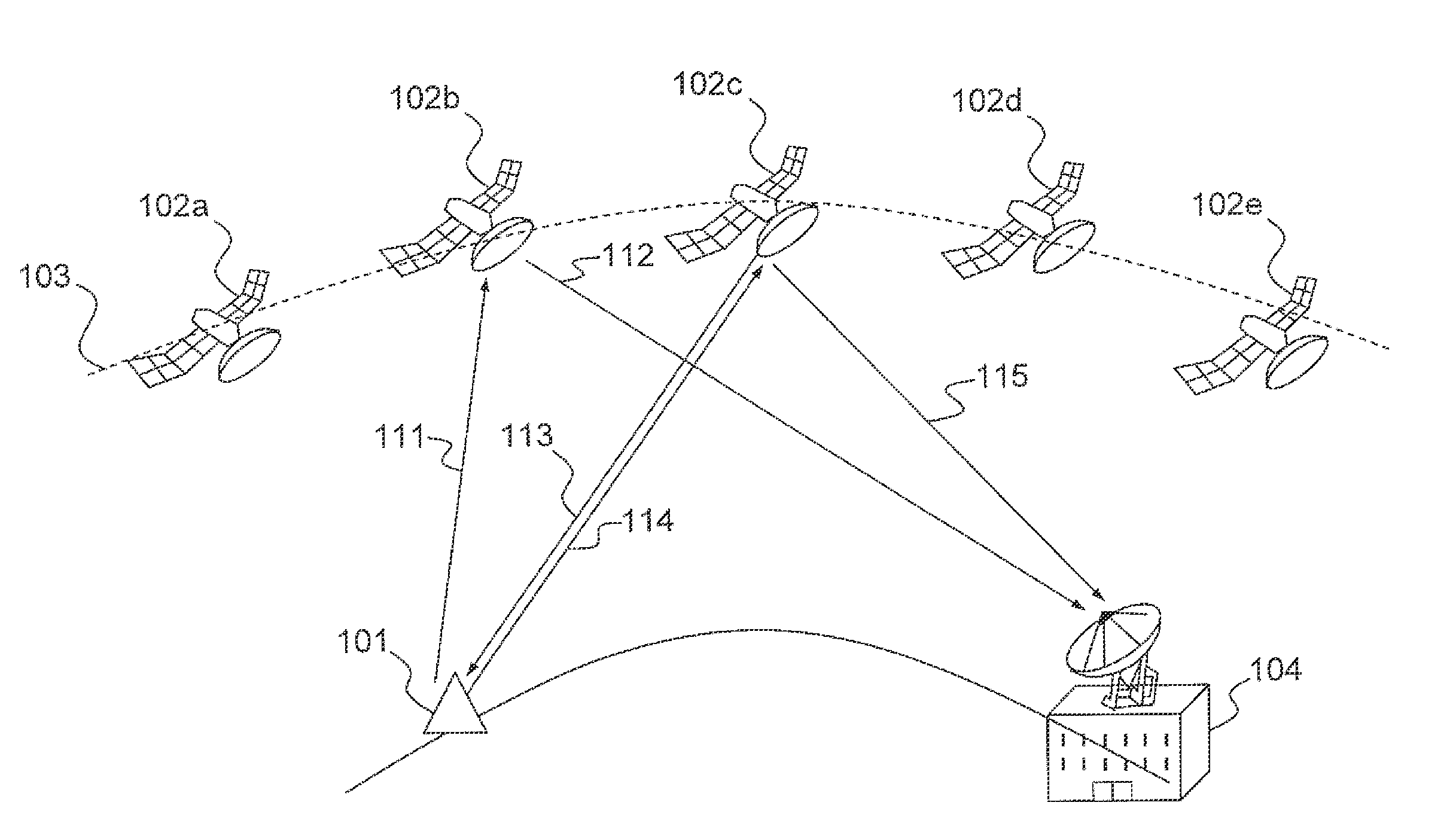
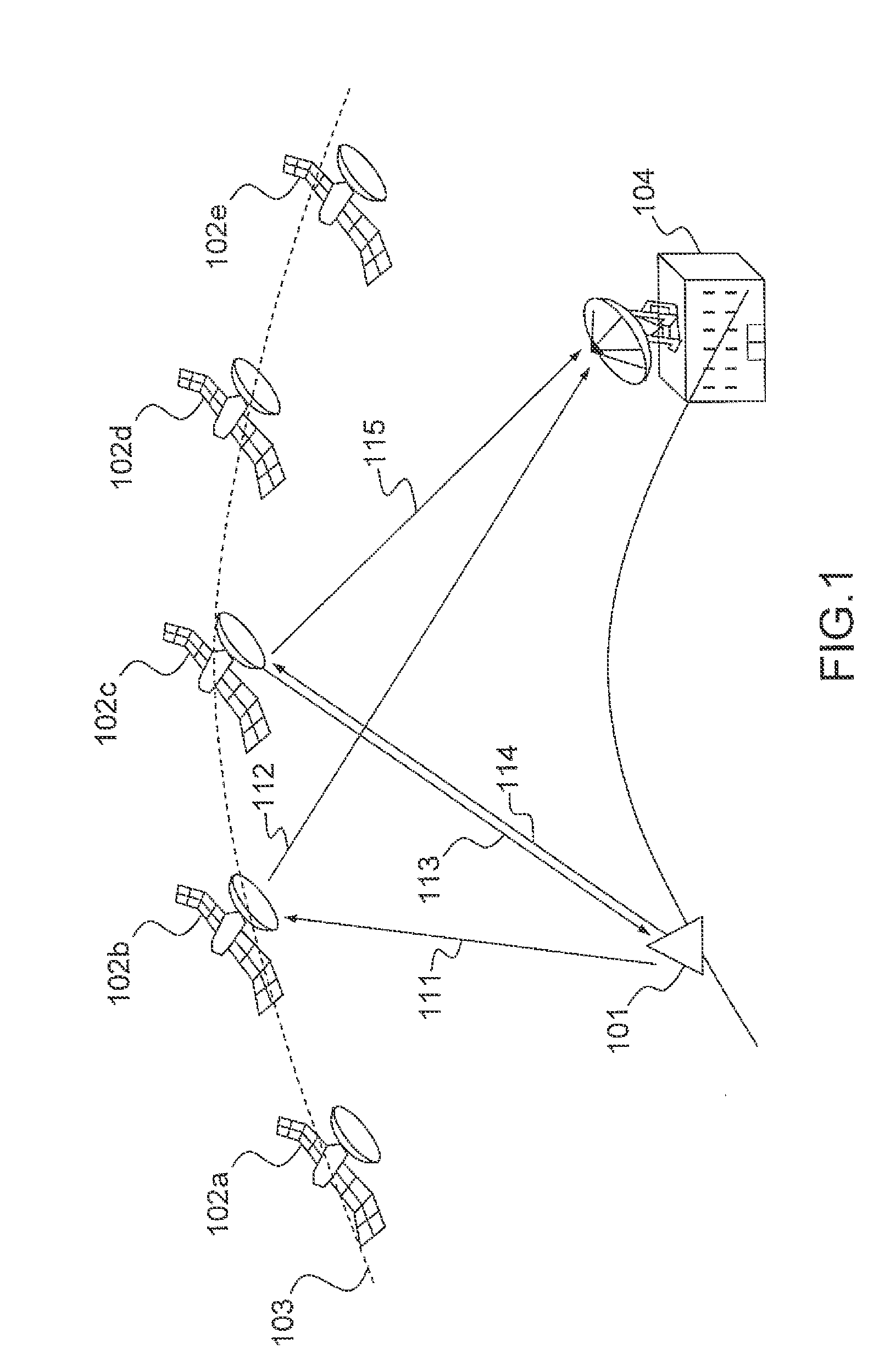
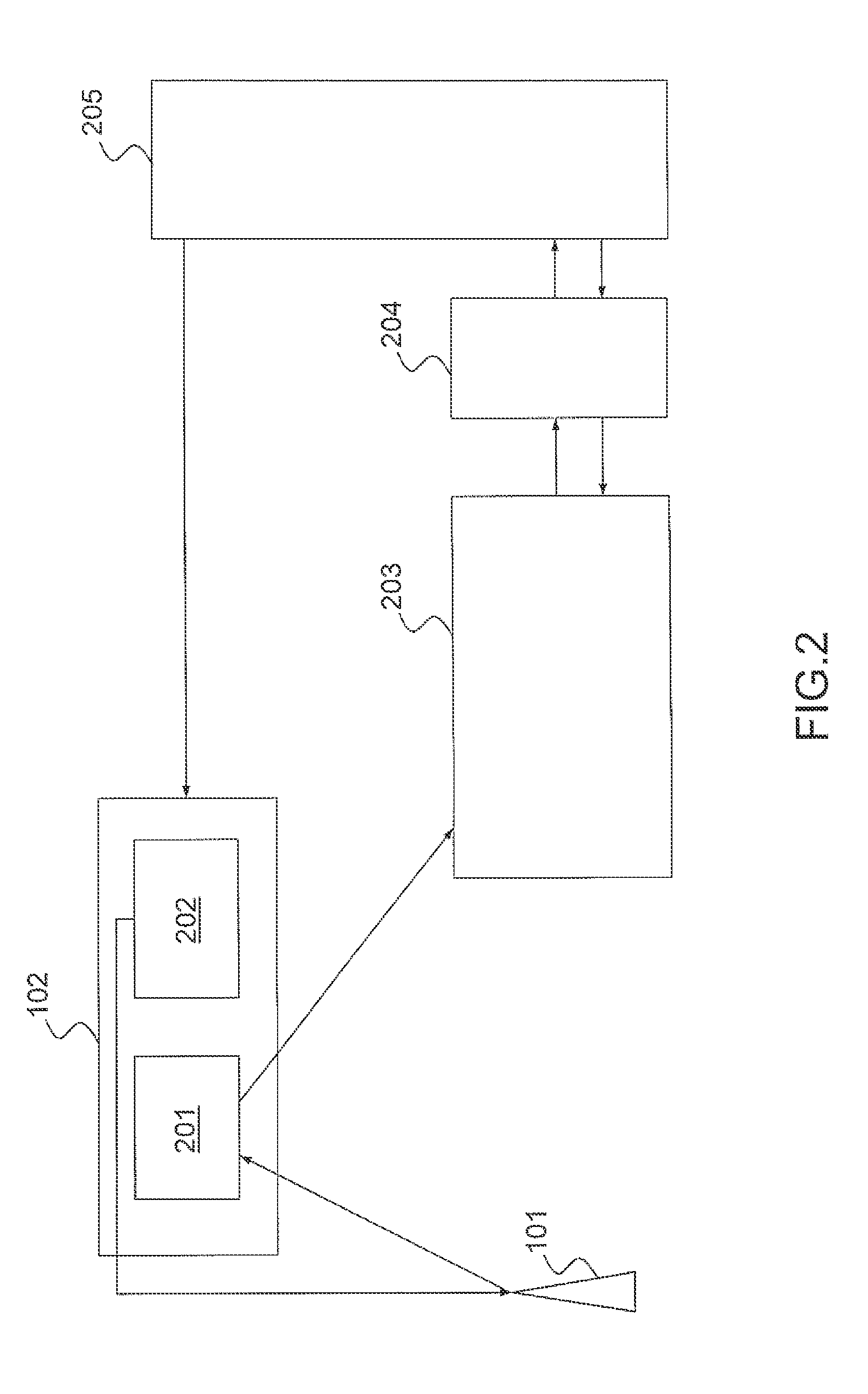
[0035]FIG. 2 is a block diagram of the geolocation system of a radio beacon according to the invention. A beacon 101 comprises means of creation and transmission of an alerting signal containing distress information. It furthermore comprises means of receiving a radio navigation signal, for example a signal transmitted by a GNSS satellite. The radio beacon 101 communicates with at least one relay satellite 102 which comprises first means 201 of reception of the alerting signal and of transmission of the said signal to a ground station 203. The relay satellite 102 furthermore comprises second means 202 of radio navigation making it possible to transmit a GNSS signal to the beacon 101 on the ground. The receiving 201 and radio navigation 202 means can be located in two different satellites. A ground station 203 receives the messages contained in the alerting signal and transmits them to a control centre which is not shown. A programming device 204 makes it possible to generate an ackn...


PUM


Abstract

A method for the geolocation of a device transmitting a signal containing at least one message to a plurality of relay satellites in a medium earth orbit, visible from said device, receiving said message and transmitting it to processing means, comprises at least the following steps: determination of the times of reception of the message by the relay satellites; determination of the pseudo-distances between the device and the relay satellites; searching for and acquiring a minimum number N of satellite radio navigation signals; determination of the time lags between the transmission of the radio navigation signals and their reception by the said device; broadcasting by the device of these time lags in the message; and, determination of the position of the device from at least the pseudo-distances, from the time lags and from the positioning coordinates of the relay satellites and of the radio navigation satellites.

Description

CROSS-REFERENCE TO RELATED APPLICATION[0001]This application claims priority to foreign French patent application No. FR 1004157, filed on Oct. 22, 2010, the disclosure of which is incorporated by reference in its entirety.FIELD OF THE INVENTION[0002]The present invention relates to a method and a system for the geolocation of a radio beacon using information transmitted within a search and rescue system associated with that radio beacon.BACKGROUND[0003]A Search and Rescue system (SAR) is formed of one or more constellations of satellites which receive, on an uplink, an alerting signal coming from a radio beacon. This signal is transmitted on an international distress frequency. The alerting signal is retransmitted to a ground station responsible for extracting from it the distress information which is then sent to a mission control centre.[0004]A known SAR system is the global Cospas-Sarsat system whose main application is the detection of accidents for boats, aircraft or individua...

Claims


Application Information

Patent Timeline
Patent Type & Authority Patents(United States)
IPC IPC(8): H04B7/185
CPCG01S19/17G01S19/46
Inventor CALMETTES, THIBAUDMONNERAT, MICHEL
Owner THALES SA
Why Eureka
Try Eureka