Snapping GPS tracks to road segments

a technology of gps track and road segment, which is applied in the direction of surveying, navigation, instruments, etc., can solve the problems of inability to provide mapping and location-based services to users, inability to accurately capture the closest road segment, and inability to meet the needs of users

Active Publication Date: 2014-05-06
GOOGLE LLC
View PDF10 Cites 46 Cited by
  • Summary
  • Abstract
  • Description
  • Claims
  • Application Information

AI Technical Summary

Problems solved by technology

However, due to certain limitations in geographic data, the position of a location aware device can be mapped to a location that is up to 150 meters away from the actual position of the location aware device.
However, association of geographic data to the closest road segment can produce inaccurate results.
Errors in associating geographic data to a road network can lead to inaccuracies in providing mapping and location-based services to users.
Conventional methods and systems are also limited in capacity and can only associate one track of a location aware device at a time to a road segment, which can be time-consuming and inefficient.

Method used


Image

  • Snapping GPS tracks to road segments
  • Snapping GPS tracks to road segments
  • Snapping GPS tracks to road segments

Examples


Embodiment Construction

Overview

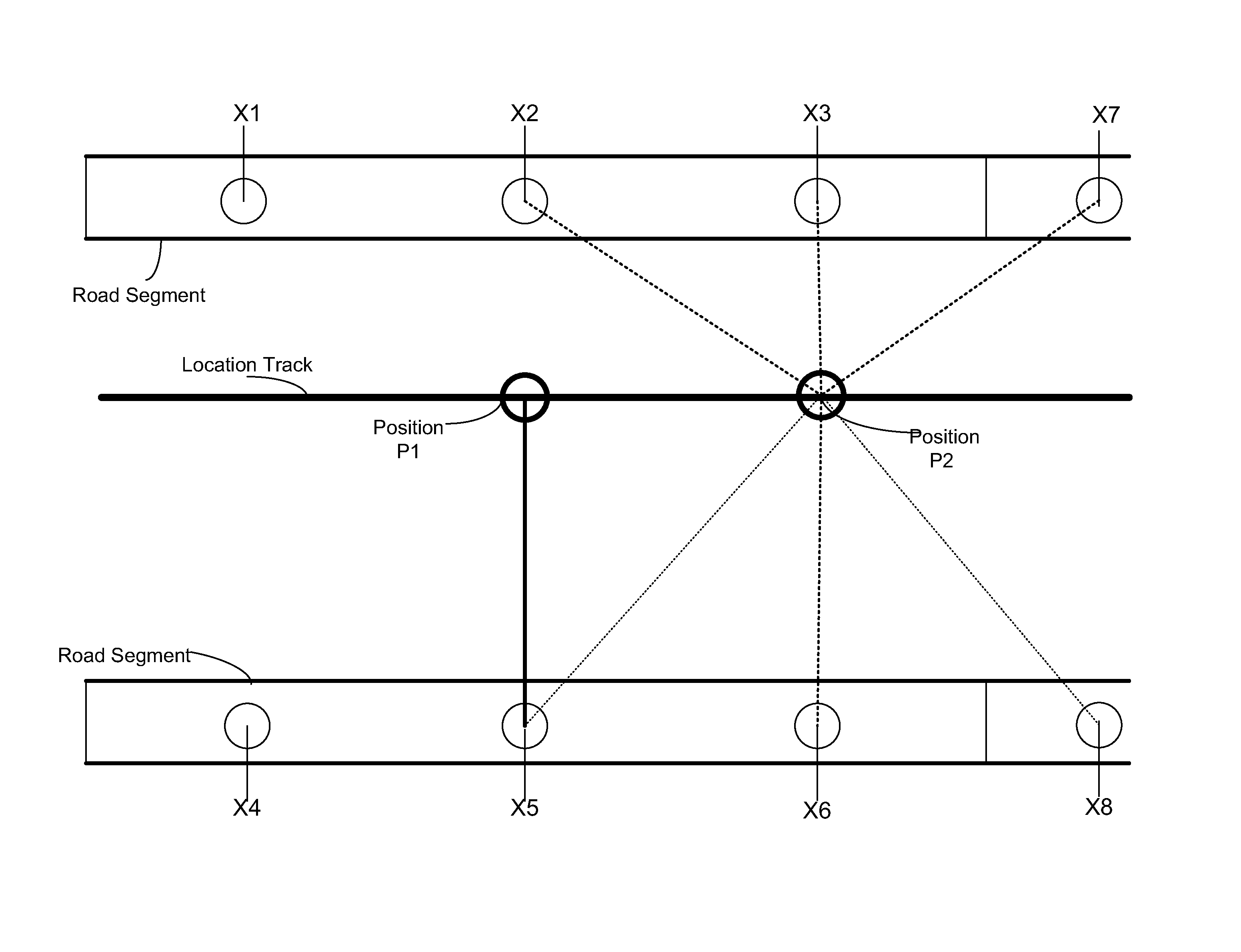
[0027]Described herein are various embodiments of systems, methods, and computer-readable storage media for associating (or “snapping”) geographic position data from location aware devices to road segments. The embodiments described herein will be discussed with respect to location aware device, such as Global Navigation Satellite System (GNSS devices), but it should be understood that other types of location aware devices, using non-GNSS type technologies may be used as well. Location aware devices can use information to determine location, such as location based services (LBS), including network-based, handset-based, SIM-based, and hybrid methods, using for example, triangulation, multilateration, cell or network identification, radio signal analysis, dead reckoning methods, including inertial navigation systems, or other non-geo-spatial satellite technologies.

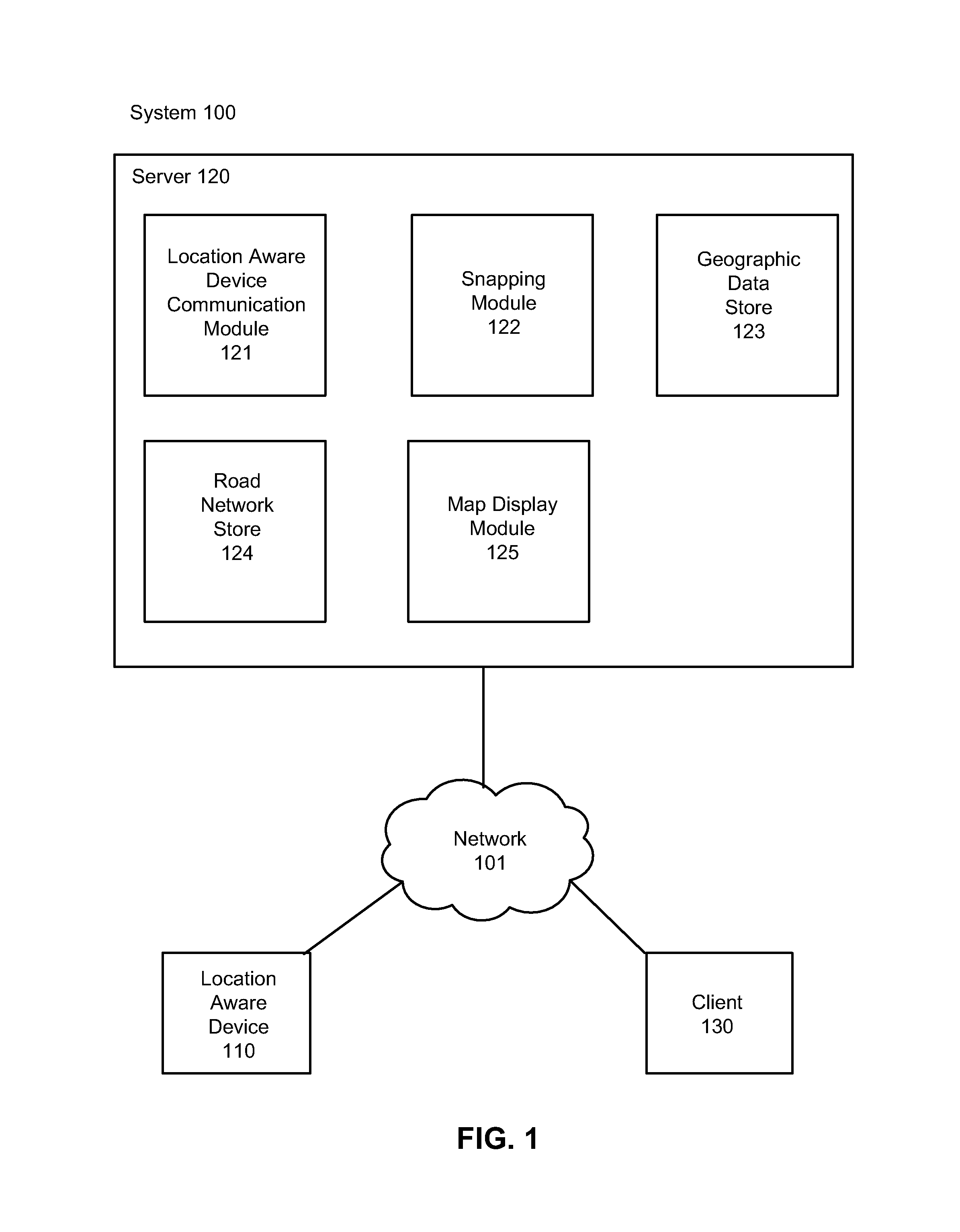
[0028]FIG. 1 is a block diagram of a system environment 100 in accordance with one embodiment. As illustrated in F...


PUM


Abstract

Methods and systems for snapping positions from location aware devices to road segments are provided. Data from the location aware device is received, which includes data about the location and direction of the location aware device. Each of the positions of the location aware device is snapped to a position on a road segment based on various factors, including the log likelihoods of snapping all of the previous positions of the location aware device to other possible positions on road segments, the comparison of direction of the location aware device and the direction of the road segment, and the distance between the location of the location aware device and the location of the road segment. Multiple threads can be generated to determine the most likely path for the location aware device. A most likely path of positions on road segments is determined for the location aware device and stored.

Description

BACKGROUND[0001]1. Field of Invention[0002]This disclosure relates generally to methods and systems for associating location data from location aware devices to road segment data in geographic information systems.[0003]2. Description of the Related Art[0004]Location aware devices are portable, electronic devices that can provide information about their current location. Location aware devices such as Global Navigation Satellite System (GNSS) devices communicate with satellites to determine the precise location of the location aware device. Location aware devices are commonly used in navigation and route guidance systems and have been included in a variety of consumer products ranging from vehicles to mobile devices. Location aware devices can provide useful information about the location and routes of users, as well as data about the position and direction of the location aware device on a given road.[0005]Providers of maps and navigational services use the information received from...

Claims


Application Information

Patent Timeline
Patent Type & Authority Patents(United States)
IPC IPC(8): G01C21/00G01C21/30
CPCG01C21/005G01C21/30
Inventor PACK, JEREMY B.OGALE, ABHIJIT S.CARCERONI, RODRIGO L.
Owner GOOGLE LLC
Why Eureka
Try Eureka