GPS trajectory data matching and complementing method

A trajectory data and completion technology, applied in the field of GPS trajectory data matching and completion, can solve problems such as deviation and missing data, and achieve good matching effect, high accuracy and repair rate, and low algorithm time and space complexity. Effect

Active Publication Date: 2020-10-30
中冶武勘智诚(武汉)工程技术有限公司
View PDF7 Cites 23 Cited by
  • Summary
  • Abstract
  • Description
  • Claims
  • Application Information

AI Technical Summary

Problems solved by technology

[0003] The purpose of the invention is to provide a method for matching and complementing GPS trajectory data, which can solve the problem of deviation between the current vehicle GPS trajec...

Method used


Image

  • GPS trajectory data matching and complementing method
  • GPS trajectory data matching and complementing method
  • GPS trajectory data matching and complementing method

Examples


Embodiment Construction

[0034] The following will clearly and completely describe the technical solutions in the embodiments of the present invention with reference to the accompanying drawings in the embodiments of the present invention. Obviously, the described embodiments are only some of the embodiments of the present invention, not all of them. Based on the embodiments of the present invention, all other embodiments obtained by persons of ordinary skill in the art without making creative efforts belong to the protection scope of the present invention.

[0035] The invention provides a technical solution:

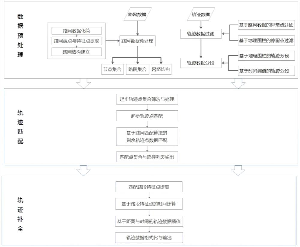
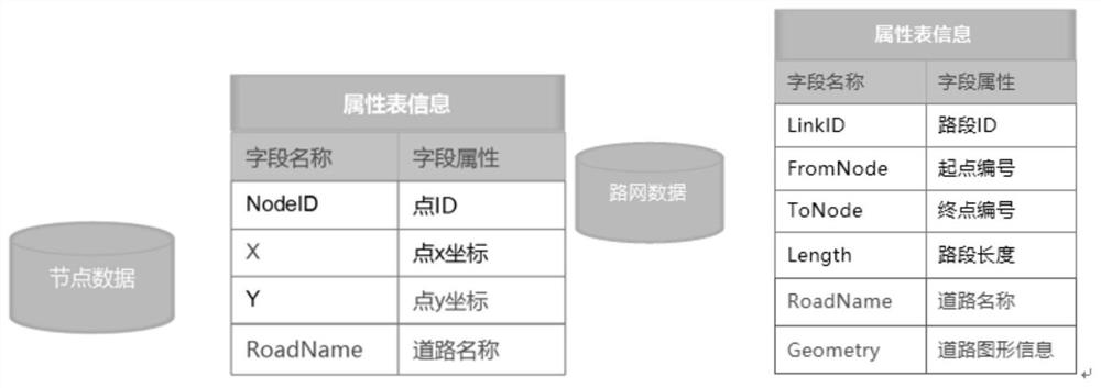
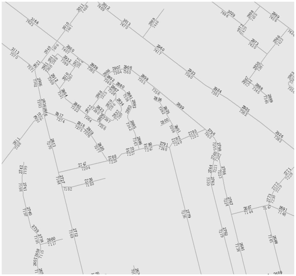
[0036] Trajectory data matching and completion is a method of GPS positioning matching and missing data completion based on software technology. This determines the position of the vehicle on the map. Then, for the missing data in the vehicle positioning trajectory, based on the positioning time and location information of GPS, comprehensively considering the global road network and trajector...


PUM


Abstract

The invention provides a GPS trajectory data matching and complementing method, which comprises the following specific steps: step 1, performing data preprocessing, including preprocessing of road network data and trajectory data; step 2, performing trajectory matching: establishing a map matching algorithm integrating the projection distance and the vehicle running state (direction and speed), and realizing the position matching of the track data; and step 3, performing track completion: establishing a trajectory interpolation method based on distance and time on the basis of constructing a road network topological relation and feature points, and realizing completion of missing trajectory data. According to the invention, the geometrical shape and topological relation of the road and thetime and speed information between adjacent trajectory points are fully considered and thus a trajectory data matching and completion algorithm is established; the trajectory data are quickly and accurately matched to a digital map, and the missing part of the trajectory is completed; and the algorithm can provide data support for trajectory data analysis and mining and trajectory data visualization.

Description

technical field [0001] The invention relates to the technical field of GPS track data processing, in particular to a method for matching and complementing GPS track data. Background technique [0002] GPS technology has been widely used in vehicle-mounted terminals, which can better realize real-time tracking of vehicles and provide assistance for dynamic monitoring and management of vehicles. From the perspective of intelligent traffic data processing and trajectory data mining, vehicle GPS data can provide data support for many aspects such as traffic situation evaluation, traffic behavior analysis, travel OD prediction, and logistics vehicle operation and maintenance. However, due to the errors of the GPS system itself, such as the stability of the GPS system (such as time synchronization, equipment network signal problems), reliability problems (such as terrain, high-rise buildings, etc., which interfere with the GPS signal reception), the vehicle is in the process of dr...

Claims


Application Information

Patent Timeline
IPC IPC(8): G08G1/0968G08G1/0969G08G1/01
CPCG08G1/0968G08G1/0108G08G1/0969
Inventor 杨恒胡伟路王凯陈龙李思蒲刘琳敏
Owner 中冶武勘智诚(武汉)工程技术有限公司
Why Eureka
Try Eureka