Method and device for determining the location of a vehicle

Active Publication Date: 2014-10-28
INIT INNOVATIVE INFORMATIKANWENDUNGEN & TRANSPORT VERKEHRS UND LEITSYSTN
View PDF20 Cites 0 Cited by
  • Summary
  • Abstract
  • Description
  • Claims
  • Application Information

AI Technical Summary

Benefits of technology

The patent text describes a method for correcting the coordinates of a vehicle's position by using data from additional sensor technology, such as a compass, gyro, or the travel path of two opposite wheels. The correction can also be done based on the vehicle's speed and time trend, or by assigning different weights to each piece of data. The result is a more accurate vehicle position.

Problems solved by technology

The method known from practice for determining the location of the vehicle, however, is problematical to the extent that it relies on good GPS reception.
This leads to interference in GPS reception and often to incorrect determination of the position of the GPS receiver.
Imprecise or incorrect projection into the coordinate system is the result.

Method used


Image

  • Method and device for determining the location of a vehicle
  • Method and device for determining the location of a vehicle

Examples


Embodiment Construction

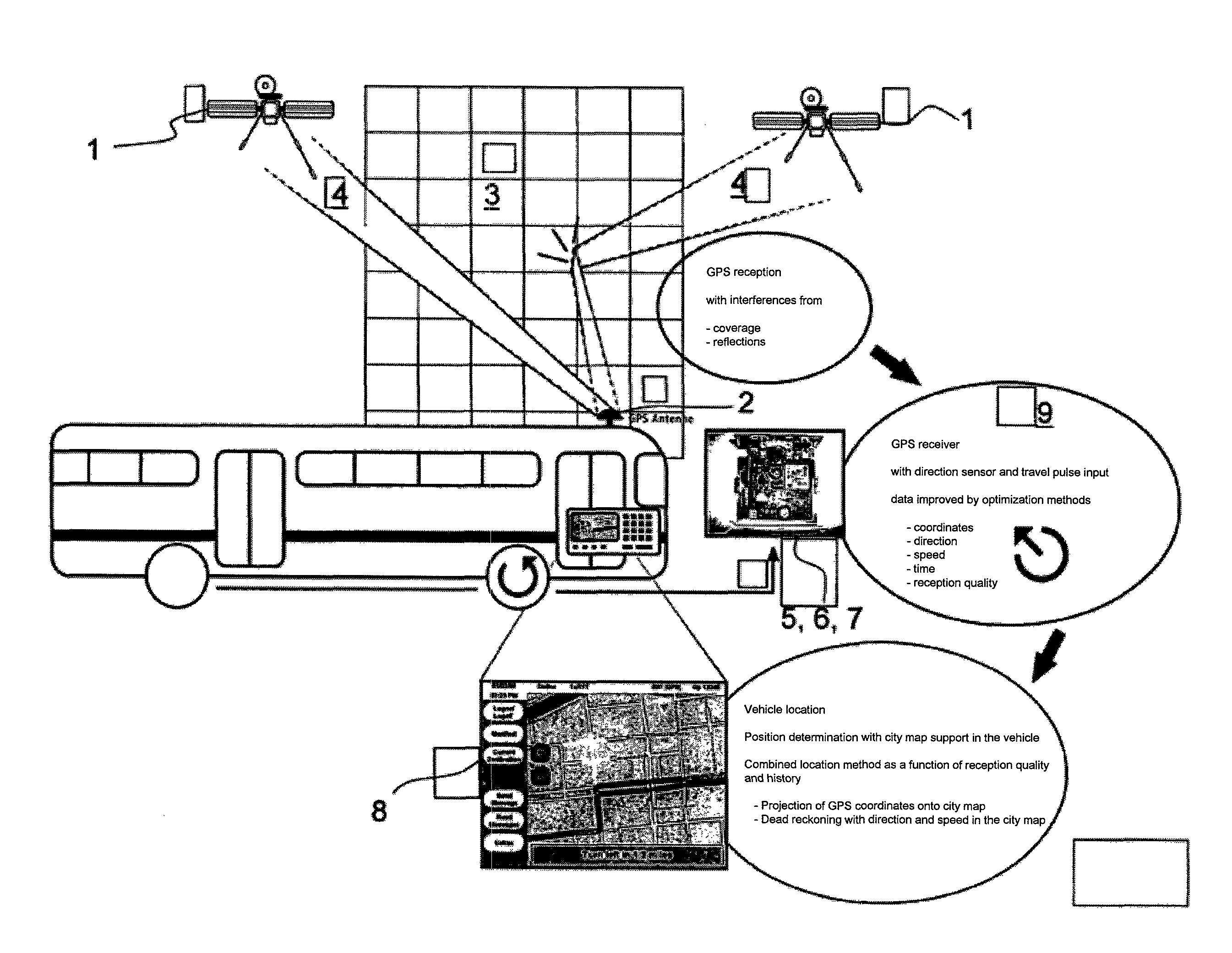
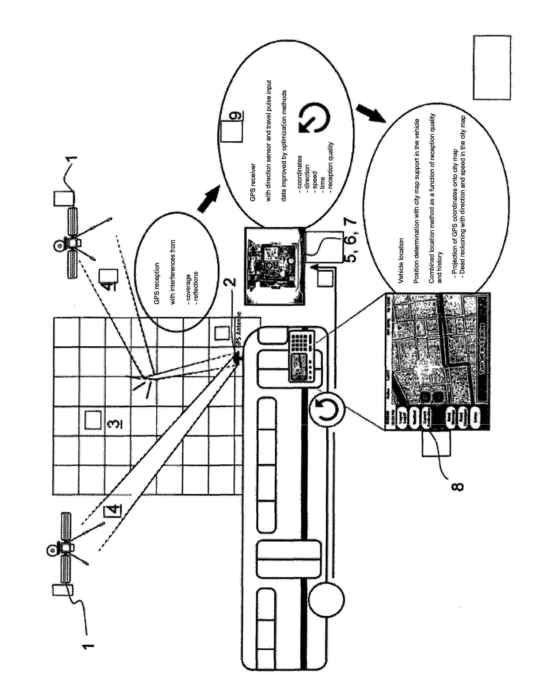
[0007]The preceding task is solved according to the invention by the various method embodiments described herein. The method known from practice for determining the location of the vehicle using a GPS receiver and a predefinable coordinate system, especially a city map, a map, a nautical chart or the like, is characterized by the following method steps:

[0008]Determination of the GPS coordinates by means of the GPS receiver or another appropriate method, for example, Galileo, beacon, etc.,

[0009]Projection of the determined coordinates onto the coordinate system and

[0010]Correction of the GPS coordinates or projected coordinates according to dead reckoning.

[0011]It was recognized according to the invention that a map-supported GPS system is not sufficient for error-free determination of the location of the vehicle, at any rate, not if the GPS signals required for determining the location, as always, are distorted or deflected or blocked. It was recognized accordingly that mere project...


PUM


Abstract

A method for determining the location of a vehicle using a GPS receiver (9) and a predefinable coordinate system, in particular a city map, a map, a nautical chart or the like, comprises the following method steps: determination of the GPS coordinates by means of a GPS receiver or some other suitable method, for example Gallileo, beacon, etc., projection of the determined coordinates onto the coordinate system and correction of the GPS coordinates or the projected coordinates in the sense of compound navigation. A corresponding device is specified.

Description

BACKGROUND OF THE INVENTION[0001]1. Field of the Invention[0002]The invention concerns a method for determining the location of a vehicle using a GPS receiver and a predefinable coordinate system, especially a city map, map, nautical chart or the like. The invention also concerns a corresponding device.[0003]2. Description of Related Art[0004]Methods and devices of the generic type are adequately known from practice in the context of now common vehicle navigation systems. A GPS receiver is used to determine the location of the vehicle and the coordinates obtained via the GPS receiver are projected onto a city map or map or a nautical chart or the like. The exact position of the corresponding vehicle on the map or on the coordinate system so defined can be determined and displayed.[0005]The method known from practice for determining the location of the vehicle, however, is problematical to the extent that it relies on good GPS reception. Especially in large cities with high buildings...

Claims


Application Information

Patent Timeline
IPC IPC(8): G08G1/0968G01S5/14G01C21/30G01C21/26G01S19/45G01C21/36G01C21/00G01C21/28
CPCG01C21/28G01C21/36G01C21/00G01C21/26G01S19/45G08G1/096827G01C21/3611
Inventor FUCHS, ALOISBINDER, FRANK
Owner INIT INNOVATIVE INFORMATIKANWENDUNGEN & TRANSPORT VERKEHRS UND LEITSYSTN
Why Eureka
Try Eureka