Method of verifying or deriving attribute information of a digital transport network database using interpolation and probe traces

a technology of digital transport network and attribute information, applied in error detection/correction, navigation instruments, instruments, etc., can solve problems such as inaccuracy or systematic errors, inability to verify or derivate attribute information of digital transport network database, and high cost of digital map production and update, etc., to achieve good attribution

Active Publication Date: 2016-03-22
TOMTOM GLOBAL CONTENT
View PDF10 Cites 0 Cited by
  • Summary
  • Abstract
  • Description
  • Claims
  • Application Information

AI Technical Summary

Benefits of technology

[0020]The invention thus has the advantage of utilizing probe traces from a plurality of users of navigation devices that traverse the problem roadway segment with missing or potentially poor attribution and that also traverse connected adjacent roadway segments with good attribution on either end of the problem segment in question. This probe data, once analyzed and statistically manipulated, may be interpolated to fill in the gaps in missing or corrupt attribution of the database in these problem segments.
[0021]An example of such an attribute is the posted speed of a roadway across the segment(s) in question. The database may show the posted speed of the connected adjacent segments to be the same (e.g., 100 km / hr) but the posted speed in the problem segment to be missing or unreliable. One cannot simply assume, without more, that the posted speed across the problem segment is the same as the posted speed of the connected segments. However, the probe data of users of navigation devices traversing the problem and connected segments can be analyzed and, if found to be generally uniform, can allow one to safely assign the missing or potentially poor attribution the same value as the attribution of the connected segments (e.g., 100 km / hr). If the probe data reveals the speed to be variable across the segments (e.g., the vehicles slow down through the problem segment), then one can also safely assume that the posted speed is different and can either interpolate the value based on the comparative probe data, or use an alternative means of learning the value of the attribution in the problem area (e.g., dispatch field personnel).
[0022]The invention thus has the advantage of resolving missing or questionable attribution based on interpolation of existing attribution data in combination with probe data to reduce and possibly eliminate the need for field personnel to be physically dispatched to problem transportation segments.

Problems solved by technology

Digital maps are expensive to produce and update, since exhibiting and processing road information is very costly.
Surveying methods or digitizing satellite images have been employed in the past for creating digital maps, but are prone to the introduction of inaccuracies or systematic errors due to faulty or inaccurate input sources or flawed inference procedures.
Once a digital map has been created, it is costly to keep map information up to date, since road geometry changes over time.
One issue associated with such methods for generating and updating digital maps using probe data relates to certain accuracy issues associated with GPS measurements.
GPS systems are designed to be as nearly accurate as possible, however various factors are known to introduce errors.
Added together, these errors cause deviations in the calculated position of the GPS receiver.
Multi-path error, also know as “urban canyon” error is a serious concern for GPS users.
However, a similar urban canyon effect can occur when segments of the transportation network are blocked from view, such as from dense tree cover or the like.
In such case, attribute information concerning the blocked segments can be all together missing or their accuracy in question or corrupt.
In a further example, the attribute may be attached to a roadway segment, but one cannot verify its accuracy or precision because the sensor, imagery or other maps from which the attributes are derived cannot themselves be verified as to accuracy.
Both approaches are recognized as being time consuming and costly, but nonetheless presently necessary in order to achieve the desired result of accurate attribution.

Method used


Image

  • Method of verifying or deriving attribute information of a digital transport network database using interpolation and probe traces
  • Method of verifying or deriving attribute information of a digital transport network database using interpolation and probe traces
  • Method of verifying or deriving attribute information of a digital transport network database using interpolation and probe traces

Examples


Embodiment Construction

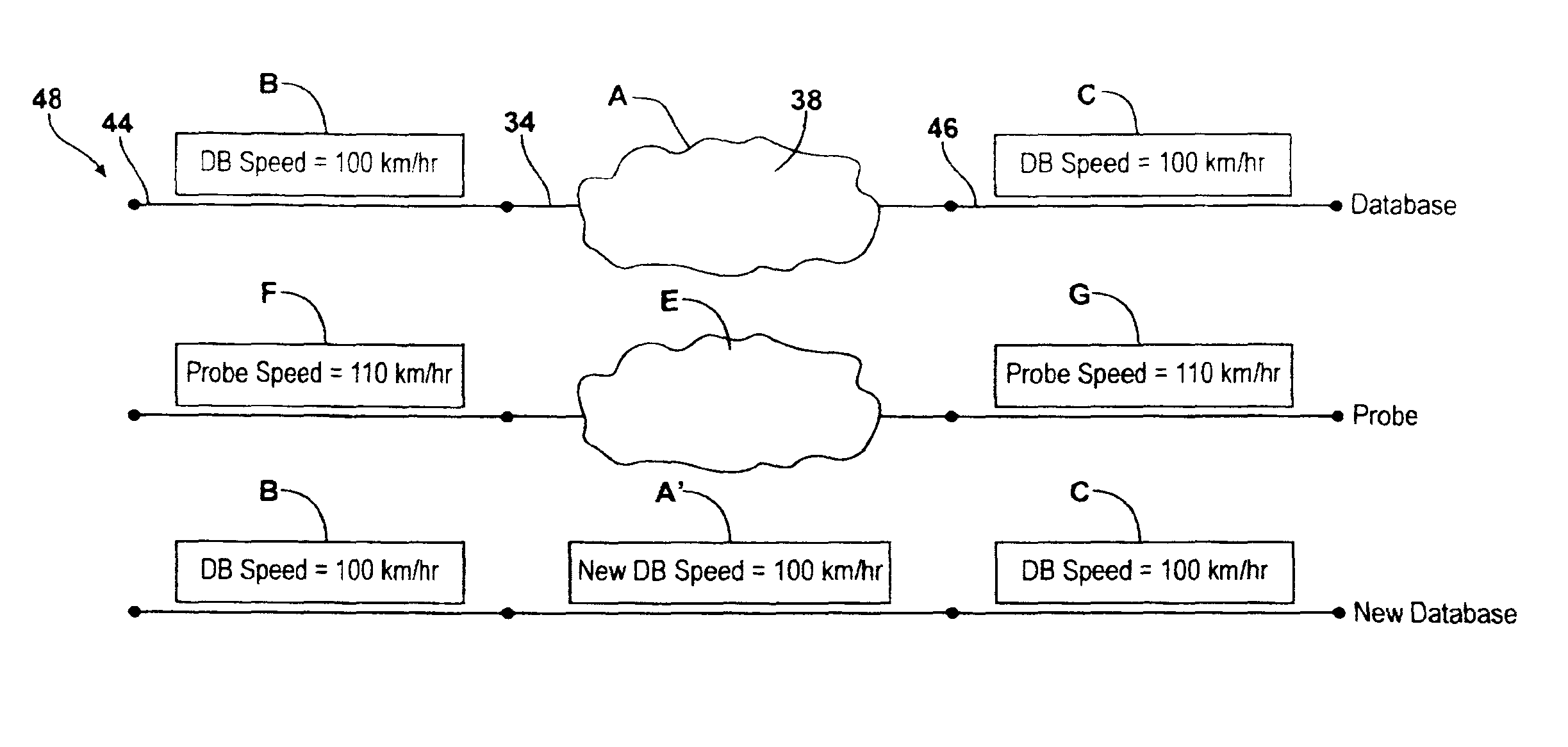
[0035]Referring to the Figures, wherein like numerals indicate like or corresponding parts throughout the several views, this invention pertains to digital transportation network navigation systems and to the digital maps, databases and devices used by navigation systems. By “digital transportation network”, it is meant to include digital mapping systems for various established transportation networks, including various roadway surfaces for motorized and non-motorized vehicles, walking, biking, skiing and hiking trails, and other established routes along which users of navigations devices travel for business or pleasure. For purposes of this invention, the term “roadway” is intended to be used in a most general way and to be inclusive of all paved and unpaved roads, paths, trails and the like for use by any type of vehicle or by a pedestrian.

[0036]This invention is applicable to correcting / updating databases of transportation networks involved with all kinds of digital navigation de...


PUM


Abstract

A method of verifying or filling in attribution associated with segments of transportation networks that are digitally mapped from a digital transportation network database includes analyzing the database to identify at least one attribute of interest that is missing or whose accuracy is unreliable and associated with a segment of the network in; identifying first and second segments before and after segment in question which have associated attribution determined to be accurate; gathering a plurality of probe traces from users of probe-transmitting navigation devices that have traversed the segment(s) in question as well as traversed the first and second; and determining whether the probe-derived attribution information is reliable, and if so, comparing the trend of the probe-derived attribute information of the first and second segments with the trend of the database attributes of the first and second segments, and if there is a positive correlation, applying the probe-derived attribute information to the database for the segment(s) in question to fill in the missing or verify the unreliable database attribution for the segment(s) in question.

Description

CROSS REFERENCE TO RELATED APPLICATIONS[0001]This application is the National Stage of International Application No. PCT / US2009 / 069945, filed Dec. 31, 2009 and designating the United States. The entire contents of this application is incorporated herein by reference. This application claims priority to U.S. Provisional Application 61 / 273,185 entitled “Method to create a digital transportation network” with a priority date of Aug. 3, 2009. The entire content of this application is incorporated by reference.STATEMENT OF COPYRIGHTED MATERIAL[0002]A portion of the disclosure of this patent document contains material which is subject to copyright protection. The copyright owner has no objection to the facsimile reproduction by anyone of the patent document or the patent disclosure, as it appears in the PTO patent file or records, but otherwise reserves all copyright rights whatsoever.BACKGROUND OF THE INVENTION[0003]1. Field of the Invention[0004]This invention relates generally to digit...

Claims


Application Information

Patent Timeline
Patent Type & Authority Patents(United States)
IPC IPC(8): G06F17/30G01C21/32G06F11/34G06F11/00
CPCG01C21/32G01C21/30G06F11/00G06F11/3466G01C21/3844G01C21/3841G01C21/3819
Inventor KENYON, SHAUNDREA, MARGARET, NEWMAN
Owner TOMTOM GLOBAL CONTENT
Why Eureka
Try Eureka