Supercharge Your Innovation With Domain-Expert AI Agents!

Discrete tracked geographical information system

A technology for tracking information and maps, which is applied in the field of geographic information systems, can solve the problems of map public application restrictions, not allowing map users to edit arbitrarily, and losing users in response time

Inactive Publication Date: 2007-12-26
朱建宇
View PDF0 Cites 13 Cited by
  • Summary
  • Abstract
  • Description
  • Claims
  • Application Information

AI Technical Summary

Problems solved by technology

[0005] Since the discrete tracking system covers a wide area, in order to facilitate query and clear display (spatial resolution up to the standard), according to business and control accuracy requirements, it is necessary to select a variety of (national, city and county) different ratios (such as 1:2000~1 : 1,000,000), which involves the problems of high cost and difficulty in large-scale application
Coupled with the issue of security and confidentiality, the public application of maps will be subject to many restrictions;
[0006] (2) The content of the general public version of the map is difficult to meet the requirements
[0008] (3) Slow display speed makes users lose confidence
In commercial affairs, the continuous waiting caused by too long response time will make users lose confidence or cause dissatisfaction;
[0010] (4) The display method is difficult to meet the personalized requirements of users
Existing WebGIS either handles the detailed display of map elements through preset map elements (including network maps) and operations such as hierarchical zooming, moving, and annotation, but users cannot add or delete their own personalized information and are in a passive query position; or allow Users can edit maps by themselves, but due to the difficulty of geographic information sources and non-standard issues, it is easy to form "information islands", affecting use and circulation;
[0012] (5) GPS-based geographic information systems do not support discrete tracking systems
[0013] GPS involves complex and massive data processing issues, and the number of tracks that can be tracked is often limited. There is no solution for logistics nodes with a large volume and wide area. Therefore, GPS-based WebGIS generally does not support discrete tracking systems;
[0014] (6) It is difficult for users to build a monitoring center by themselves
[0015] Some WebGIS are based on (CGI or Server API) server application systems, while others are based on (Plug-in, ActiveX, Java Applet) client application systems. Both systems have their own advantages and disadvantages, because the characteristics and operating conditions of WebGIS are different. Similarly, the models and mechanisms used are also very different, resulting in difficult user selection, difficult use and maintenance, and high application costs. It is difficult for a large number of small and medium-sized users of the discrete tracking system to build their own monitoring centers;
[0016] (7) Difficult to achieve interoperability
[0019] The construction of a large-scale transportation physical network (including logistics nodes) requires frequent updates of the map, and users naturally hope to see the latest version of the map. However, any local modification of geographic information in a short period of time cannot be immediately updated in the current version It is reflected on the map that the version cannot be upgraded quickly
In addition, in terms of version maintenance subjects, due to the standardization, authority and confidentiality of massive geographic information, and the complexity of information resource supply channels, standardized electronic maps are usually provided and maintained by departments such as planning and surveying and mapping. Map users can edit at will
Therefore, users first wait for a long time, and then bring upgrade costs

Method used


Image

  • Discrete tracked geographical information system
  • Discrete tracked geographical information system
  • Discrete tracked geographical information system

Examples


Embodiment Construction

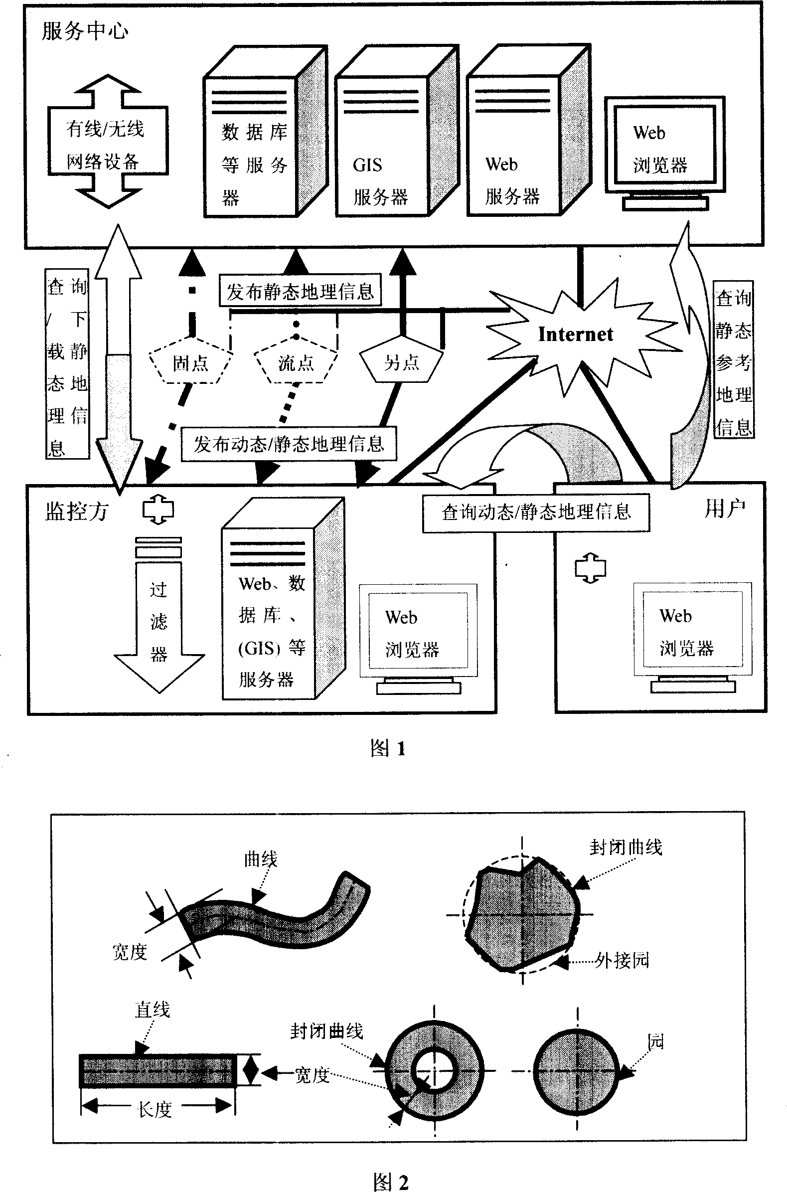
[0088] Discrete tracking information receiving process:

[0089] During the call receiving process, according to the IP phone service mode, set up a dedicated phone access, and enter the standard coded information according to the voice prompt sequence;

[0090] In the fax receiving process, receive the standard fax format, scan the fax content and automatically identify it and store it;

[0091] Letter receiving process, receive standard letters, scan the content of the letter and automatically identify and store it;

[0092] During the fixed-point receiving process, the standard coded information sent by the fixed-point is received through wired or wireless;

[0093] During the receiving process of RFID flow point and PDT flow point, the position of RFID flow point or PDT flow point is calculated according to the fixed point and offset distance, and the standard coded information is received through wireless SMS;

[0094] In the continuous receiving process of GPS flow point...


PUM


Abstract

A geographic information system of discrete track is prepared for using service center to provide reference source map bottom layer, providing download service and pick-up as well as hide of map by right map layer, using boundary and boundary chain layer as well as countermark to form network map and picture as well as data, receiving discrete track information from fixed point and flowing point as well as separated point to provide discrete track information query and navigation service in map-mode webpage way then enabling user to browse webpage of service center to obtain dynamic or static geographic information.

Description

field of invention [0001] The invention relates to a geographic information system related to a cargo discrete tracking system and method. Users who need discrete tracking information can obtain the location and location of discrete tracking objects such as cargo, transportation devices, and people through the Internet (Internet) in a relatively short period of time. Traffic, weather and other navigation information. Background technique [0002] The inventor provides a system and method for discrete tracking of goods in the patent "System and Method for Discrete Tracking of Goods". The (goods) discrete tracking system passes through various logistics nodes, RF (radio frequency) cards, Real-time collection of discrete tracking information such as (graphic) codes, including static geographic information, dynamic geographic information and other information. Static geographic information refers to feature images and data that do not change or rarely change over time, such as ...

Claims


Application Information

Patent Timeline
IPC IPC(8): G06F17/30
Inventor 朱建宇朱环宇
Owner 朱建宇
Features
  • R&D
  • Intellectual Property
  • Life Sciences
  • Materials
  • Tech Scout
  • Unparalleled Data Quality
  • Higher Quality Content
  • 60% Fewer Hallucinations
Learn More