Strict collinearity equation model of satellite-borne SAR image

A technology of collinear equations and images, applied in the radio wave measurement system, radio wave reflection/re-radiation, using re-radiation, etc., to achieve the effect of satisfying the ground positioning

Inactive Publication Date: 2009-11-04
BEIHANG UNIV
View PDF0 Cites 9 Cited by
  • Summary
  • Abstract
  • Description
  • Claims
  • Application Information

AI Technical Summary

Problems solved by technology

[0003] The invention solves the approximation problem of the imaging geometric model of the spaceborne SAR image, and deduces the strict collinear equa

Method used


Image

  • Strict collinearity equation model of satellite-borne SAR image
  • Strict collinearity equation model of satellite-borne SAR image
  • Strict collinearity equation model of satellite-borne SAR image

Examples


Embodiment Construction

[0011] The spaceborne SAR strict collinear equation model of the present invention will be described in detail below in conjunction with the accompanying drawings.

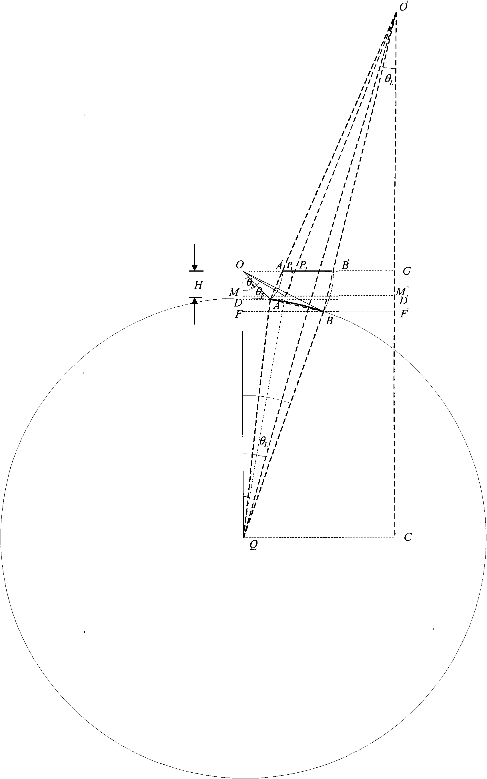
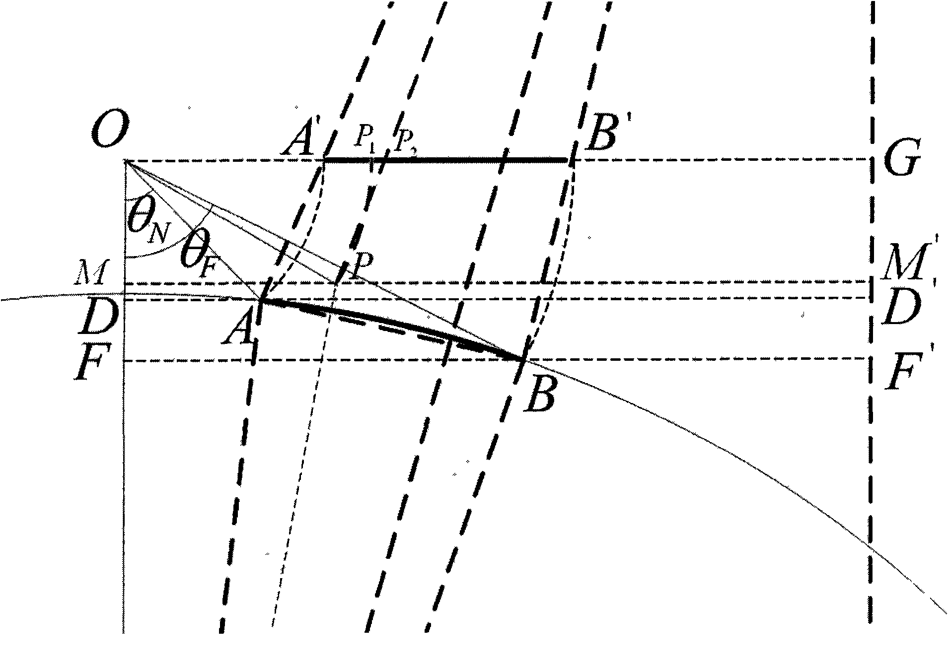
[0012] The all-satellite SAR strict collinear equation model provided by the present invention is realized through the following steps, as figure 1 shown. The SAR image obtained by imaging processing is an oblique range image, figure 1 A schematic diagram of the geometry of a SAR image acquired in azimuth is given. Point Q is the origin of the earth coordinates, point O is the position of the phase center of the SAR sensor antenna, and the flying height of the SAR satellite is H, its sub-satellite point is point E, and points A and B are the near and far points of the SAR image respectively. distance point. Points O, Q, A, and B are in the same plane, draw a vertical line OG through point O on this plane, and find points A' and B' on OG, so that OA and OA' are equal, and OB and OB' are equal. Connect points A ...


PUM


Abstract

The invention discloses a strict collinearity equation model of a satellite-borne SAR image. In the model, the derivation is carried out aiming at an earth ellipsoid model, a virtual projection center is built at each orientation of the SAR image, and a computing method of external parameter and equivalent focal length of a virtual projection center sensor and a revision method from a slant-distance image to a central projection image are derived. The method solves the following problems: (1), an approximate collinearity equation model is not strict; and (2), a ground control point is required to carry out image geocoding when the external parameter of the sensor is unknown.

Description

technical field [0001] The invention relates to the field of synthetic aperture radar imaging geometric models, in particular, it establishes a strict collinear equation model of spaceborne SAR images. Background technique [0002] The imaging geometric model of SAR images is oblique range imaging, and usually the collinear equation model cannot be directly used to locate SAR image targets. In most cases, photogrammetry scholars can use the approximate collinear equation model of SAR images to locate SAR images, but because the model used is approximate, this will directly lead to inaccurate image positioning. At present, there is also a SAR strict collinear equation model, which is derived on the basis of approximating the earth's surface as a plane, without using the earth's ellipsoid model, so this strict collinear equation model is ideal for airborne SAR images Strict, but essentially approximate for spaceborne SAR images. Contents of the invention [0003] The inven...

Claims


Application Information

Patent Timeline
IPC IPC(8): G01S13/90
Inventor 刘慧周荫清徐华平
Owner BEIHANG UNIV
Why Eureka
Try Eureka