Live-action information system and method thereof based on GPS positioning and direction identification technology

A GPS positioning and direction recognition technology, applied in the field of navigation and positioning systems, can solve the problems of inability to dynamically combine the data of scenic spots, not being vivid enough, interesting, and lacking methods for observing and querying surrounding scenery

Inactive Publication Date: 2010-05-05
上海易标信息科技有限公司
View PDF4 Cites 51 Cited by
  • Summary
  • Abstract
  • Description
  • Claims
  • Application Information

AI Technical Summary

Problems solved by technology

[0005] However, the above-mentioned devices are not vivid and interesting enough in the information display, cannot be dynamically combined with the data of scenic spots, and lack vivid observation and query methods for surrounding scenery.

Method used


Image

  • Live-action information system and method thereof based on GPS positioning and direction identification technology
  • Live-action information system and method thereof based on GPS positioning and direction identification technology
  • Live-action information system and method thereof based on GPS positioning and direction identification technology

Examples


Embodiment Construction

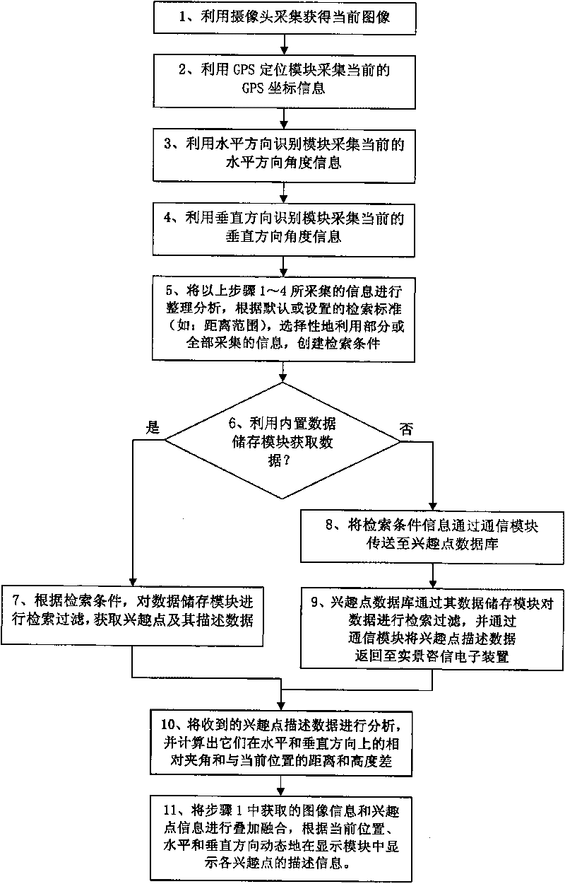
[0052] A preferred embodiment of the present invention will be specifically introduced below in conjunction with the accompanying drawings.

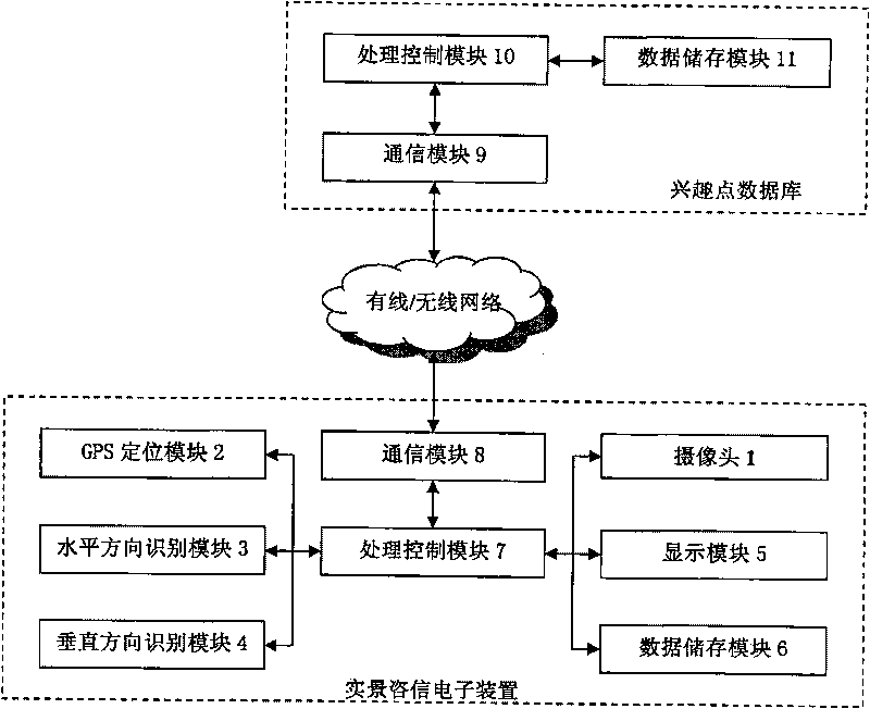
[0053] see figure 1 and figure 2, The present invention is a real-scene information information system based on GPS positioning and direction recognition technology, which mainly includes: a real-scene information information device based on GPS positioning and direction recognition technology, a communication network and a point-of-interest database.

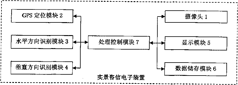
[0054] Such as figure 1 As shown in , the real-scene consulting electronic device based on GPS positioning and direction recognition technology mainly includes: a camera 1, a GPS positioning module 2, a horizontal direction recognition module 3, a vertical direction recognition module 4, a display module 5, and a data storage module 6 And the processing control module 7, the processing control module 7 is connected to the other six modules.

[0055] Such as figure 2 As shown in , th...


PUM


Abstract

The invention relates to live-action information system and method thereof based on a GPS positioning and direction identification technology, comprising a live-action information device, a communication network and an interest database. The live-action information device comprises a camera, a GPS positioning module, a horizontal and vertical direction identification module, a display module, a data storage module and a processing control module, wherein the processing control module is connected with the other six modules. The method comprises the following steps of: picking up an external live-action image by the camera, acquiring current GPS coordinate information by the GPS positioning module, acquiring information by adopting the horizontal and vertical direction identification module, analyzing the information to establish searching criteria, identifying, acquiring points of interest and describing data of the points of interest, transmitting the data to the interest database, and overlying and fusing the information to show the describing information of the points of interest. The invention has the advantages of perfect dynamic fusion of live action and data, lively observation and inquiry to surrounding scenes, precise, convenient and visualized information about directions and distances of the points of interest, and rich content of the surrounding points of interest.

Description

technical field [0001] The invention relates to a navigation and positioning system, in particular to a real-scene information consulting system based on GPS positioning and direction recognition technology and a method thereof. Background technique [0002] Existing peripheral information query systems perform queries through the network or the GPS function of mobile terminals. They have no direction judgment function, complex query operations, and can only display simple two-dimensional map information. Traditional navigation and surrounding information query applications use text, which has the problems of being unintuitive and complicated to operate. [0003] In order to solve the above problems, Chinese Patent Publication No. CN101510208 discloses a tourist attraction intelligent tour guide system based on high-precision positioning, which consists of an intelligent tour guide service center, a data processing center, a data release platform, an intelligent tour guide i...

Claims


Application Information

Patent Timeline
Patent Type & Authority Applications(China)
IPC IPC(8): G06F17/30G01S19/42H04L29/06
Inventor 高翔厉敬东
Owner 上海易标信息科技有限公司
Why Eureka
Try Eureka