Method for generating crossing actual scene induced map of navigation electronic map

A technology of electronic maps and induced maps, applied in the directions of maps/plans/charts, road network navigators, instruments, etc., can solve the problems of easy to miss, no special prompt information prompt method, insufficient machine intelligence of navigation electronic map data, etc. Easy to use, increase the effect of the direction indicator board

Inactive Publication Date: 2010-06-09
DMG INFOTECH +1
View PDF0 Cites 44 Cited by
  • Summary
  • Abstract
  • Description
  • Claims
  • Application Information

AI Technical Summary

Problems solved by technology

[0007] However, due to various complicated situations, especially when making an intersection judgment, when the above-mentioned instruction method is not correctly understood by the user, it is easy to cause detours and wrong situations.
[0008] As you can imagine, when a car navigator user drives a vehicle at a high speed, the actual road conditions they face are often much more complicated than the map on the display device
Maybe I saw a right-turning road on the map, but I didn't see anything after walking for a long time. As a result, the navigation suggested that the car had missed it... At this time, the intersection sign may be aging and not obvious. It may be that the intersection is hidden by something just blocking the line of sight. In short, it is easy to miss if you are not careful.
[0009] At present, the navigation electronic map data is obviously insufficient in terms of machine intelligence, and there is no subdivision of special roads, especially the actual shape of complex intersections and the reference of surrounding features
Without any comparison of reference information, even if the user has identified the orientation and road shape, it is difficult to find the connection between the actual road conditions and the road on the map, and it is difficult to find the exact intersection
This is mainly because there is no corresponding special prompt information and special prompt method in the current navigation electronic map data

Method used


Image

  • Method for generating crossing actual scene induced map of navigation electronic map
  • Method for generating crossing actual scene induced map of navigation electronic map
  • Method for generating crossing actual scene induced map of navigation electronic map

Examples


Embodiment 1

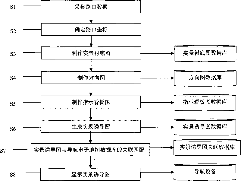
[0032] At intersection 1, step S1 collects intersection data, collects photos of intersection 1 and saves them in the database. For photos, see figure 2 ; Step S2 determines intersection coordinates, determines the coordinate position of intersection road, matches with the coordinate position of navigation electronic map; Step S3 makes real scene substrate map, makes real scene substrate map on computer according to the intersection direction of photo, on the real scene substrate map Including the direction of intersection roads and a small number of abstracted buildings, multiple real-scene base maps can be made according to time such as morning, noon or night, and weather conditions such as sunny, rainy, cloudy, etc. The format is stored in the real scene substrate map database, and the coordinate position of the road at the intersection is used as a mark point; step S4 is to make a direction map, and the direction map is made for each road at the intersection on the computer...

Embodiment 2

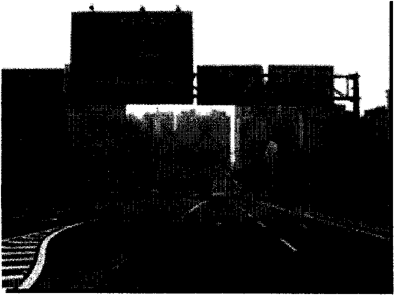
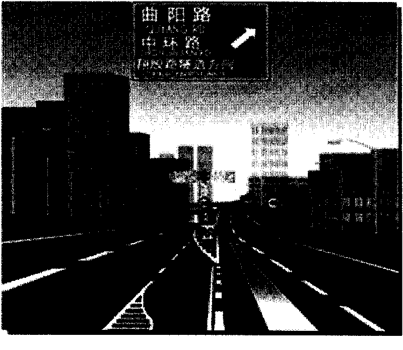
[0035] At the intersection 2, the steps of generating the real-scene induction map are basically the same as those in Embodiment 1, wherein the instruction board map made in step S5 is consistent with the actual road traffic signboard, including text, color, and similar proportions, which are basically the same, but more clearly and clearly . See the actual photos of the intersection Figure 4 , the generated real-scene induction map is shown in Figure 5 .


PUM


Abstract

The invention provides a method for generating a crossing actual scene induced map of a navigation electronic map. The method comprises the following steps: acquiring crossing data, determining a crossing coordinate, drawing an actual scene underlay map, drawing a directional map, drawing a direction indication billboard map, generating an actual scene induced map, and performing associated matching between the actual scene induced map and a navigation electronic map database. The actual scene induced map generated by the invention abandons unrelated elements in a common actual scene map, highlights the crossing direction, increases a direction indication billboard, and can help a user observe the map more clearly and look up the direction so as to reduce the situations of detouring and going wrong.

Description

technical field [0001] The invention relates to a method for generating a navigation electronic map intersection diagram, in particular to a method for generating a navigation electronic map intersection guidance diagram. Background technique [0002] With the continuous popularization of GPS satellite positioning technology in civil and commercial use, and the continuous development of the automotive electronics industry, drivers provide convenience for driving by equipping their cars with navigation equipment for positioning, guiding and displaying electronic maps. Compared with traditional paper maps, navigation electronic maps have obvious advantages. One is large scale and high precision. The other is that each scale can be quickly converted to each other. Road attributes are complete, POI information is rich, and traffic control information is included. Integrated geographic information makes traditional paper maps incomparable. In addition, GPS satellite positioning ...

Claims


Application Information

Patent Timeline
IPC IPC(8): G01C21/32G09B29/00
Inventor 赵斌廖健良
Owner DMG INFOTECH
Why Eureka
Try Eureka