Grassland satellite remote sensing monitoring system and method

A satellite remote sensing and monitoring system technology, applied in radio wave measurement systems, measurement devices, electromagnetic wave re-radiation, etc., can solve problems that cannot be directly applied

Active Publication Date: 2011-04-27
INST OF AGRI RESOURCES & REGIONAL PLANNING CHINESE ACADEMY OF AGRI SCI
View PDF3 Cites 44 Cited by
  • Summary
  • Abstract
  • Description
  • Claims
  • Application Information

AI Technical Summary

Problems solved by technology

[0007] At present, the research on grass-livestock balance is mostly based on small-area experiments or models, and the research on grass-livestock balance in large areas is often not directly applicable.

Method used


Image

  • Grassland satellite remote sensing monitoring system and method
  • Grassland satellite remote sensing monitoring system and method
  • Grassland satellite remote sensing monitoring system and method

Examples


Embodiment Construction

[0071] The technical solutions of the present invention will be further described in more detail in conjunction with the accompanying drawings and specific embodiments.

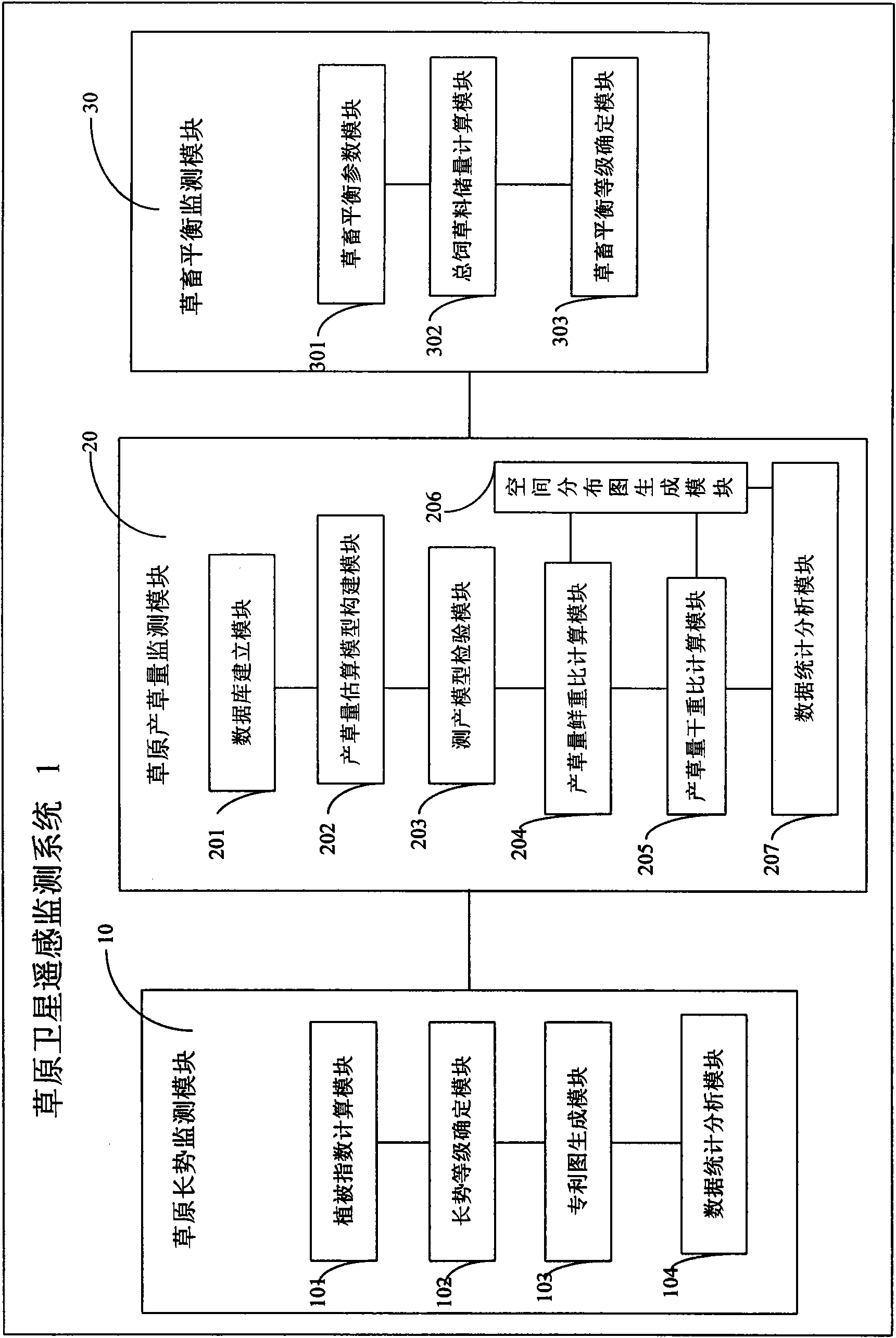
[0072] figure 1 It is the structural block diagram of the grassland satellite remote sensing monitoring system of the present invention, refer to figure 1 The grassland satellite remote sensing system 1 includes a grassland growth monitoring module 10 , a grassland grass yield monitoring module 20 , and a grassland-livestock balance monitoring module 30 . Among them, the grassland growth monitoring module 10 is used to obtain the grassland vegetation index NDVI and the grassland growth index GI through the satellite remote sensing MODIS data processing in different periods according to the relationship between the remote sensing information and the grassland vegetation status, so as to reflect the grassland vegetation growth; Quantity monitoring module 20, is used for through satellite remote sensing MODIS i...


PUM


Abstract

The invention discloses a grassland satellite remote sensing monitoring system and a grassland satellite remote sensing monitoring method. The system comprises a grassland growth potential monitoring module, a grassland grass yield monitoring module and a grass-livestock balance monitoring module, wherein the grassland growth potential monitoring module is used for acquiring a grassland normalized difference vegetation index (NDVI) and a grassland growth index (GI) by processing data of a satellite remote sensing moderate resolution imaging spectrometer (MODIS) in different periods according to the relation between remote sensing information and the condition of grassland vegetation on the ground to reflect the growth potential of the grassland vegetation; the grassland grass yield monitoring module is used for establishing a grass yield estimating model by combining yield measuring data of ground quadrats according to the information of the satellite remote sensing MODIS and inverting the grass yield of grasslands according to the data of the remote sensing MODIS; and the grass-livestock balance monitoring module is used for estimating the grass-livestock balance condition by combining the current grass yield, foraged grass yield and replenished forage grass of natural grasslands according to the grass yield acquired by the grassland grass yield monitoring module.

Description

technical field [0001] The invention relates to grassland monitoring technology, in particular to a grassland satellite remote sensing monitoring system and method based on MODIS (Moderate Resolution Imaging Spectrometer) data. Background technique [0002] Grassland vegetation remote sensing monitoring is the use of 3S technology (remote sensing, geographic information system and global positioning system), combined with ground survey data to realize the monitoring of grassland vegetation. The content of remote sensing monitoring of grassland vegetation mainly includes the growth of grassland vegetation, the biomass of grassland vegetation and the estimation of the balance of grassland and livestock. With the continuous development and maturity of 3S technology, especially the rapid development of earth observation technology, the continuous improvement of high temporal and spatial resolution satellite remote sensing data acquisition technology, and the rapid development of...

Claims


Application Information

Patent Timeline
Patent Type & Authority Applications(China)
IPC IPC(8): G01S17/00G06F19/00
Inventor 徐斌杨秀春陶伟国刘海启王道龙覃志豪
Owner INST OF AGRI RESOURCES & REGIONAL PLANNING CHINESE ACADEMY OF AGRI SCI
Why Eureka
Try Eureka