Method for measuring river-crossing levelling altitude difference by using GPS (global positioning system)

A level and height difference technology, applied in the field of surveying and mapping, can solve the problems of low stability of linear fitting model and large error of level difference across rivers, etc., achieve stable calculation results, reduce workload and improve work efficiency

Inactive Publication Date: 2011-07-13
长江水利委员会长江勘测规划设计研究院 +1
View PDF1 Cites 6 Cited by
  • Summary
  • Abstract
  • Description
  • Claims
  • Application Information

AI Technical Summary

Benefits of technology

The technical effect described in this patented technology allows for more efficient monitoring of water levels on roads during construction or maintenance operations without requiring expensive equipment such as sensors at specific locations along their length. This makes it easier than traditional methods that require costly specialized hardware installations.

Problems solved by technology

This patented technical problem addressed in the patents relating to bridge building engineering involves measuring levels on both ends of rivers or waterways during construction processes for ensuring proper placement of temporary structures such as fences or levees. Current methods are slow and require expensive equipment, which makes them difficult to use with existing surveying techniques like satellite navigation systems (Satellite Navigation Systems).

Method used


Image

  • Method for measuring river-crossing levelling altitude difference by using GPS (global positioning system)
  • Method for measuring river-crossing levelling altitude difference by using GPS (global positioning system)
  • Method for measuring river-crossing levelling altitude difference by using GPS (global positioning system)

Examples


Embodiment Construction

[0013] Further illustrate the present invention below in conjunction with specific embodiment:

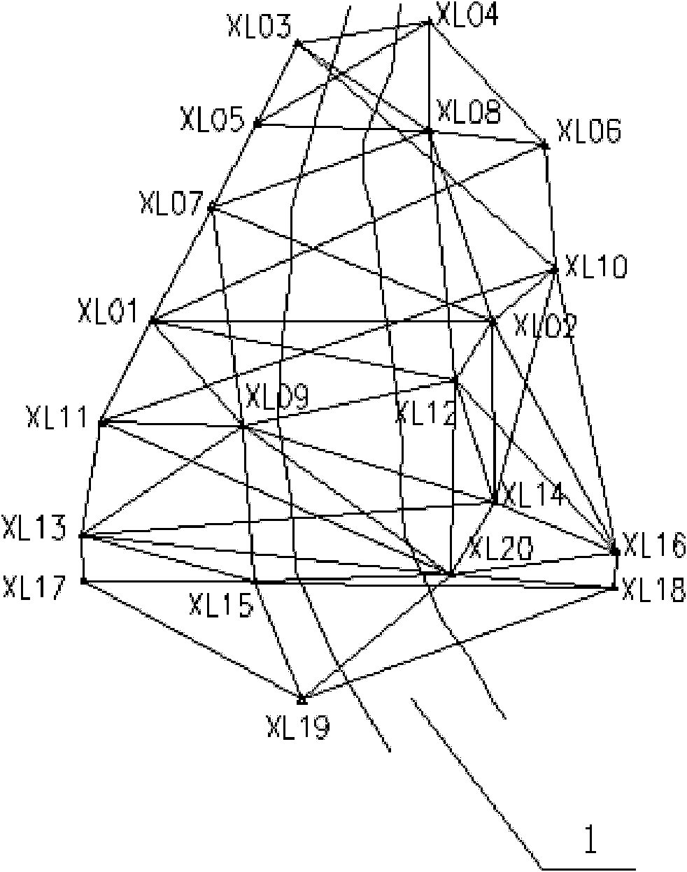
[0014] Such as figure 1 As shown, the GPS engineering control network of a certain water conservancy project consists of 20 points on both sides of a certain river 1, and the control area is about 15km 2 . Select XL15 and XL20 as cross-river benchmarks, and there are network points distributed in the direction of their backs to the river, and the connection line is perpendicular to the river direction. The GPS geodetic elevation of each network point in the GPS engineering control network is to use the WGS84 coordinates and observation values ​​of the three nearest GPS continuous operation reference stations in the surrounding area to jointly adjust with any point in the GPS engineering control network to obtain the WGS84 coordinates of the point, and then Fix this point and carry out three-dimensional adjustment of GPS engineering control network, so as to obtain the GPS geodeti...


PUM


Abstract

The invention discloses a method for measuring river-crossing levelling altitude difference by using a GPS (global positioning system), which comprises the following steps: selecting at least two groups of control network points (two in each group) at two sides of a river in a GPS engineering control network as river-crossing levelling points; measuring the GPS geodetic elevation of each point at two sides of the GPS engineering control network to obtain the GPS geodetic altitude difference between the river-crossing levelling points; levelling to obtain the levelling elevation of each control network point of the known river, assuming that the levelling altitude difference between the two river-crossing control network points in one selected group is unknown, and calculating the known levelling elevation of the other river control network point containing the unknown; building a curved surface or plane fitting model according to the relationship between the GPS geodetic elevation and the levelling elevation at the same control network point; and calculating the levelling elevation and river-crossing levelling altitude difference of the assumed river-crossing levelling points by using a least square method. By using the method to measure the river-crossing levelling altitude difference, the workload is reduced, and the working efficiency is improved. Meanwhile, the calculated river-crossing levelling altitude difference has high stability, and the result is reliable.

Description


Claims


Application Information

Patent Timeline
Owner 长江水利委员会长江勘测规划设计研究院
Why Eureka
Try Eureka